Canadian Sessional Papers Collection
| ID | Map Title | Map Date | Sessional Paper | Preview | Image Files | Geography Covered | Subjects | Scale |
|---|---|---|---|---|---|---|---|---|
| 1 | Plan And Profile Nelson River | 1901 | Vol. 35, Issue 01 Sessional Paper # 19 |
 |
jpeg tif |
Nelson River | Nelson River | 3 : 30 miles |
| 2 | Map Of The Country Adjacent To The 60th Parallel Of Latitude From Teslin Lake To Lake Bennett | 1900 | Vol. 35, Issue 10 Sessional Paper # 25 |
 |
jpeg tif |
Teslin Lake Lake Bennett Yukon Territory British Columbia |
Lake Teslin To Lake Bennett | 1 inch:6 miles |
| 3 | Map Of Atlin Gold Fields British Columbia | 1901 | Vol. 35, Issue 11 Sessional Paper # 26 |
 |
jpeg tif |
Atlin Gold Fields British Columbia |
Atlin Gold Fields | 1 inch:6 miles |
| 4 | Map Of Atlin Gold Fields British Columbia | 1901 | Vol. 35, Issue 11 Sessional Paper # 26 |
 |
jpeg tif |
1 inch:6 miles | ||
| 5 | Paardeberg 1st Engagement, Position Of Ix Division In Which Was 2nd Royal Canadian Regiment | 1900 | Vol. 35, Issue 12 Sessional Paper # 35a |
 |
jpeg tif |
Paardeberg Modder River South Africa |
Boer War Paardeberg Battle |
6 inch:1 mile |
| 6 | Paardeberg Action Of 20th February 1900 Showing Disposition Of Xix Brigade | 1900 | Vol. 35, Issue 12 Sessional Paper # 35a |
 |
jpeg tif |
Modder River Paardeber South Africa |
Paardeberg Battle Boer War |
6 inch:1 mile |
| 7 | Battle Of Doorn Kop Showing Disposition Of Xix Brigade With Royal Canadian Regt | 1900 | Vol. 35, Issue 12 Sessional Paper # 35a |
 |
jpeg tif |
Doorn Kop South Africa |
Battle Of Doorn Kop Boer War |
6 inch:1 mile |
| 8 | Map Of Provisional Boundary Line White Pass And Chilkoot Pass According To The Modus Vivendi | 1899 | Vol. 35, Issue 13 Sessional Paper # 35a |
 |
jpeg tif |
White Pass Chilkoot Pass |
Plane Table Survey White Pass | 1:5000 |
| 9 | Copy Of Plan Submitted With Orders In Council Of 20th Feb 1907 | 1907 | Vol. 35, Issue 13 Sessional Paper # 35a |
 |
jpeg tif |
Chilkat River Salmon River British Columbia |
Chilkat River | no scale given |
| 10 | Map Showing Provisional Boundary Link In The Region Of The Dalton Trail According To The Modus Vivendi October 20, 1899 | 1900 | Vol. 35, Issue 13 Sessional Paper # 35a |
 |
jpeg tif |
Klehini River Alaska |
Dalton Trail Provisional Boundary Line |
1:20,000 |
| 11 | Plan Of Pte. Levis Live Stock Quarantine | Vol. 36, Issue 06 Sessional Paper # 35a |
 |
jpeg tif |
Pte. Levis | Pte. Levis Live Stock Quarantine | no scale given | |
| 12 | Topographical Plan Of The French River Showing The Main Channel To Be Adapted To A Navigation Of 20 Foot Draught With A Profile Of Its Water Surface, As Surveyed By J.W. Fraser In 1901; Also Its Other Channels Taken From Alex Murray'S Surveys Of 1847, 55 And 57 | Vol. 36, Issue 07 Sessional Paper # 35a |
 |
jpeg tif |
French River Lake Nipissing Georgian Bay |
French River | 1 inch:i mile | |
| 13 | Map Showing The Principal Transportation Routes From The Head Of The Great Lakes Via Montreal, New York &C., To Liverpool | 1901 | Vol. 36, Issue 07 Sessional Paper # 35a |
jpeg tif |
Great Lakes And Surrounding Cities St. Lawrence River |
Transportation Routes Of The Eastern Seaboard | no scale given | |
| 14 | River St. Lawrence Ship Channel Between Montreal And Quebec | 1901 | Vol. 36, Issue 07 Sessional Paper # 35a |
 |
jpeg tif |
St. Lawrence River Montreal Quebec |
Quebec Shipping Route | printed on map |
| 15 | Map Showing Progress Of Surveys: Montreal, Ottawa, & Georgian Bay Canal | <190 | Vol. 36, Issue 08 Sessional Paper # 35a |
 |
jpeg tif |
Great Lakes And Surrounding Cities | Montreal, Ottawa, Georgian Bay Surveys | no scale given |
| 16 | Map Showing Progress Of Surveys: Montreal, Ottawa, & Georgian Bay Canal | 1902 | Vol. 36, Issue 08 Sessional Paper # 35a |
 |
jpeg tif |
Ontario Quebec |
Montreal, Ottawa, & Georgian Bay Canal Surveys | 6 miles : 1 inch |
| 17 | Map Showing The Exploration Made On Proposed Railway To Yukon District | 1902 | Vol. 36, Issue 08 Sessional Paper # 35a |
 |
jpeg tif |
British Columbia Alberta |
Yukon Railway | 50 miles : 1 inch |
| 18 | Dominion Of Canada | 1901 | Vol. 36, Issue 08 Sessional Paper # 35a |
 |
jpeg tif |
Canada | Canadian Railway Routes | no scale given |
| 19 | Map Showing Railways In Parts Of British Columbia And Alberta | 1901 | Vol. 36, Issue 08 Sessional Paper # 35a |
 |
jpeg tif |
Southern British Columbia Alberta |
Western Railways | printed on map |
| 20 | Map Showing Railways In Manitoba, Assiniboia, And Part Of Saskatchewan | 1901 | Vol. 36, Issue 08 Sessional Paper # 35a |
 |
jpeg tif |
Manitoba Assiniboia Saskatchewan |
Railways In Western Canada | printed on map |
| 21 | Map Showing Railway In Parts Of Ontario And Manitoba | 1901 | Vol. 36, Issue 08 Sessional Paper # 35a |
 |
jpeg tif |
Ontario Manitoba |
Railway In Western And Central Canada | printed on map |
| 22 | Map Showing Railways In Parts Of Ontario And Quebec | 1901 | Vol. 36, Issue 08 Sessional Paper # 35a |
 |
jpeg tif |
Ontario Quebec |
Railyways In Central Canada | printed on map |
| 23 | Map Showing Railways In Nova Scotia, New Brunswick, P.E. Island, And Part Of Quebec | 1901 | Vol. 36, Issue 08 Sessional Paper # 35a |
 |
jpeg tif |
Nova Scotia New Brunswick Prince Edward Island Quebec |
Railways In Central And Eastern Canada | printed on map |
| 24 | Map Showing The St. Lawrence, Ottawa, Rideau, And Richelieu Canals | 1902 | Vol. 36, Issue 08 Sessional Paper # 35a |
 |
jpeg tif |
Ontario Quebec St. Lawrence River Ottawa River Rideau Canal Richelieu Canal |
Ontario Rivers And Canals Quebec Rivers And Canals |
10 miles : 1 inch |
| 25 | Map Showing Trent Navigation And Murray Canal | 1902 | Vol. 36, Issue 08 Sessional Paper # 35a |
 |
jpeg tif |
Eastern Ontario | Trent Canal Murray Canal |
10 miles : 1 inch |
| 26 | Map Of The Dominion Of Canada | 1901 | Vol. 36, Issue 10 Sessional Paper # 35a |
 |
jpeg tif |
Canada | Canada | 100 miles : 1 inch |
| 27 | Map Shewing Exploration Between Lakes Winnipeg, Manitoba, And Winnipegosis | 1901 | Vol. 36, Issue 10 Sessional Paper # 35a |
 |
jpeg tif |
Lake Winnipeg Lake Manitoba Lake Winnipegosis Manitoba |
Manitoba Exploration | 6 miles : 1 inch |
| 28 | Map Of The Country Adjacent To The 60th Parallel Of Latitude From Teslin Lake To Alsek River | 1900 | Vol. 36, Issue 10 Sessional Paper # 35a |
 |
jpeg tif |
British Columbia Yukon Territory |
Land Between Teslin Lake And Alsek River | 6 miles : 1 inch |
| 29 | Map Of Exploration Survey Of Divide Between Great Slave Lake And Hudson Bay, Districts Of Mackenzie And Keewatin, Dominion Of Canada, To Accompany Report Of James W. Tyrrell C.E. D.L.S. | 1900 | Vol. 36, Issue 10 Sessional Paper # 35a |
 |
jpeg tif |
Doobaunt River Aberdeen Lake Northwest Territories |
Exploration Survey | printed on map |
| 30 | Map Of Exploration Survey Of Divide Between Great Slave Lake And Hudson Bay, Districts Of Mackenzie And Keewatin, Dominion Of Canada, To Accompany Report Of James W. Tyrrell C.E. D.L.S. | 1900 | Vol. 36, Issue 10 Sessional Paper # 35a |
 |
jpeg tif |
Aberdeen Lake Northwest Territories |
Exploration Survey | printed on map |
| 31 | Map Of Exploration Survey Of Divide Between Great Slave Lake And Hudson Bay, Districts Of Mackenzie And Keewatin, Dominion Of Canada, To Accompany Report Of James W. Tyrrell C.E. D.L.S. | 1900 | Vol. 36, Issue 10 Sessional Paper # 35a |
 |
jpeg tif |
Schultz Lake Lower Thelon River Northwest Territories |
Exploration Survey | printed on map |
| 32 | Map Of Exploration Survey Of Divide Between Great Slave Lake And Hudson Bay, Districts Of Mackenzie And Keewatin, Dominion Of Canada, To Accompany Report Of James W. Tyrrell C.E. D.L.S. | 1900 | Vol. 36, Issue 10 Sessional Paper # 35a |
 |
jpeg tif |
Baker Lake Kazan River Northwest Territories Sugar Loaf Mountain |
Exploration Survey | printed on map |
| 33 | Map Of Exploration Survey Of Divide Between Great Slave Lake And Hudson Bay, Districts Of Mackenzie And Keewatin, Dominion Of Canada, To Accompany Report Of James W. Tyrrell C.E. D.L.S. | 1900 | Vol. 36, Issue 10 Sessional Paper # 35a |
 |
jpeg tif |
Baker Lake Bowell Islands Christopher Island Northwest Territories |
Exploration Survey | printed on map |
| 34 | Map Of Exploration Survey Of Divide Between Great Slave Lake And Hudson Bay, Districts Of Mackenzie And Keewatin, Dominion Of Canada, To Accompany Report Of James W. Tyrrell C.E. D.L.S. | 1900 | Vol. 36, Issue 10 Sessional Paper # 35a |
 |
jpeg tif |
Chesterfield Inlet Northwest Territories |
Exploration Survey | printed on map |
| 35 | Map Of Exploration Survey Of Divide Between Great Slave Lake And Hudson Bay, Districts Of Mackenzie And Keewatin, Dominion Of Canada, To Accompany Report Of James W. Tyrrell C.E. D.L.S. | 1900 | Vol. 36, Issue 10 Sessional Paper # 35a |
 |
jpeg tif |
Chesterfield Inlet Hudson Bay Northwest Territories |
Exploration Survey | printed on map |
| 36 | Map Of Exploration Survey Of Divide Between Great Slave Lake And Hudson Bay, Districts Of Mackenzie And Keewatin, Dominion Of Canada, To Accompany Report Of James W. Tyrrell C.E. D.L.S. | 1900 | Vol. 36, Issue 10 Sessional Paper # 35a |
 |
jpeg tif |
Eyeberry Lake Thelon River Northwest Territories |
Exploration Survey | printed on map |
| 37 | Map Of Exploration Survey Of Divide Between Great Slave Lake And Hudson Bay, Districts Of Mackenzie And Keewatin, Dominion Of Canada, To Accompany Report Of James W. Tyrrell C.E. D.L.S. | 1900 | Vol. 36, Issue 10 Sessional Paper # 35a |
 |
jpeg tif |
Thelon River Northwest Territories |
Exploration Survey | printed on map |
| 38 | Map Of Exploration Survey Of Divide Between Great Slave Lake And Hudson Bay, Districts Of Mackenzie And Keewatin, Dominion Of Canada, To Accompany Report Of James W. Tyrell C.E. D.L.S. | 1900 | Vol. 36, Issue 10 Sessional Paper # 35a |
 |
jpeg tif |
Mackenzie District Keewatin District Great Slave Lake Hudson Bay |
Exploration Survey, Districts Of Mackenzie And Keewatin | printed on map |
| 39 | Map Of Exploration Survey Of Divide Between Great Slave Lake And Hudson Bay, Districts Of Mackenzie And Keewatin, Dominion Of Canada, To Accompany Report Of James W. Tyrrell C.E. D.L.S. | 1900 | Vol. 36, Issue 10 Sessional Paper # 35a |
 |
jpeg tif |
Thelon River Northwest Territories |
Exploration Survey | printed on map |
| 40 | Map Of Exploration Survey Of Divide Between Great Slave Lake And Hudson Bay, Districts Of Mackenzie And Keewatin, Dominion Of Canada, To Accompany Report Of James W. Tyrrell C.E. D.L.S. | 1900 | Vol. 36, Issue 10 Sessional Paper # 35a |
 |
jpeg tif |
Tyrrell Lake Island Lake Nelligan Lake Mary Frances Lake Northwest Territories |
Exploration Survey | printed on map |
| 41 | Map Of Exploration Survey Of Divide Between Great Slave Lake And Hudson Bay, Districts Of Mackenzie And Keewatin, Dominion Of Canada, To Accompany Report Of James W. Tyrrell C.E. D.L.S. | 1900 | Vol. 36, Issue 10 Sessional Paper # 35a |
 |
jpeg tif |
Artillery Lake Ford Lake Campbell Lake Northwest Territories |
Exploration Survey | printed on map |
| 42 | Map Of Exploration Survey Of Divide Between Great Slave Lake And Hudson Bay, Districts Of Mackenzie And Keewatin, Dominion Of Canada, To Accompany Report Of James W. Tyrrell C.E. D.L.S. | 1900 | Vol. 36, Issue 10 Sessional Paper # 35a |
 |
jpeg tif |
Artillery Lake Northwest Territories |
Exploration Survey | printed on map |
| 43 | Map Of Exploration Survey Of Divide Between Great Slave Lake And Hudson Bay, Districts Of Mackenzie And Keewatin, Dominion Of Canada, To Accompany Report Of James W. Tyrrell C.E. D.L.S. | 1900 | Vol. 36, Issue 10 Sessional Paper # 35a |
 |
jpeg tif |
Casba Lake Casba River Northwest Territories |
Exploration Survey | printed on map |
| 44 | Map Of Exploration Survey Of Divide Between Great Slave Lake And Hudson Bay, Districts Of Mackenzie And Keewatin, Dominion Of Canada, To Accompany Report Of James W. Tyrrell C.E. D.L.S. | 1900 | Vol. 36, Issue 10 Sessional Paper # 35a |
 |
jpeg tif |
Sifton Lake Manitoba |
Exploration Survey | printed on map |
| 45 | Map Of Exploration Survey Of Divide Between Great Slave Lake And Hudson Bay, Districts Of Mackenzie And Keewatin, Dominion Of Canada, To Accompany Report Of James W. Tyrrell C.E. D.L.S. | 1900 | Vol. 36, Issue 10 Sessional Paper # 35a |
 |
jpeg tif |
Hanbury River Sandy Lake Northwest Territories |
Exploration Survey | printed on map |
| 46 | Map Of Exploration Survey Of Divide Between Great Slave Lake And Hudson Bay, Districts Of Mackenzie And Keewatin Dominion Of Canada, To Accompany Report Of James W. Tyrrell C.E. D.L.S. | 1900 | Vol. 36, Issue 10 Sessional Paper # 35a |
 |
jpeg tif |
Thelon River Northwest Territories |
Exploration Survey | printed on map |
| 47 | Map Of Exploration Survey Of Divide Between Great Slave Lake And Hudson Bay, Districts Of Mackenzie And Keewatin, Dominion Of Canada, To Accompany Report Of James W. Tyrrell C.E. D.L.S. | 1900 | Vol. 36, Issue 10 Sessional Paper # 35a |
 |
jpeg tif |
Thelon River Northwest Territories |
Exploration Survey | printed on map |
| 48 | Map Of Exploration Survey Of Divide Between Great Slave Lake And Hudson Bay, Districts Of Mackenzie And Keewatin, Dominion Of Canada, To Accompany Report Of James W. Tyrrell C.E. D.L.S. | 1900 | Vol. 36, Issue 10 Sessional Paper # 35a |
 |
jpeg tif |
Thelon River Northwest Territories |
Exploration Survey | printed on map |
| 49 | Map Of Exploration Survey Of Divide Between Great Slave Lake And Hudson Bay, Districts Of Mackenzie And Keewatin, Dominion Of Canada, To Accompany Report Of James W. Tyrell C.E. D.L.S. | 1900 | Vol. 36, Issue 10 Sessional Paper # 35a |
 |
jpeg tif |
Thelon River Beverly Lake Northwest Territories |
Exploration Survey | printed on map |
| 50 | Index To The Sheets Of J.W. Tyrrell'S Map Of Exploration From Great Slave Lake To Hudson Bay, Districts Of Mackenzie And Keewatin, Dominion Of Canada | 1900 | Vol. 36, Issue 10 Sessional Paper # 35a |
 |
jpeg tif |
Northwest Territories Area Between Great Slave Lake And Hudson Bay Districts Of Mackenzie And Keewatin |
Exploration Survey | printed on map |
| 51 | Sketch Map Of The Lake Abitibi Region To Accompany Summary Reports By W.J. Wilson Ph.B. And J.F.E. Johnston | 1901 | Vol. 36, Issue 11 Sessional Paper # 35a |
 |
jpeg tif |
Lake Abiti Region Ontario Quebec |
Geological Survey Of Canada | 16 miles : 1 inch |
| 52 | Geological Sketch Map Of Parts Of Kings And Hants Counties, N.S., To Accompany Summary Report By Hugh Fletcher, B.A. | 1901 | Vol. 36, Issue 11 Sessional Paper # 35a |
 |
jpeg tif |
Kings County Hants County Nova Scotia |
Geological Survey Of Canada | 2 miles : 1 inch |
| 53 | Sketch Map Of Salmon River Gold Field, Yukon Territory, To Accompany Summary Report By R.G. Mcconnell B.A. | 1901 | Vol. 36, Issue 11 Sessional Paper # 35a |
 |
jpeg tif |
Salmon River Yukon Territory |
Gold Field In Salmon River, Yukon Territory | 2 miles : 1 inch |
| 54 | Index Map Of Southern British Columbia, To Accompany The List Of Publications | 1901 | Vol. 36, Issue 11 Sessional Paper # 35a |
 |
jpeg tif |
Southern British Columbia | Geoglogical Survey Of Canada | 50 miles : 1 inch |
| 55 | Index Map Of Northwestern Ontario, To Accompany The List Of Publications | 1901 | Vol. 36, Issue 11 Sessional Paper # 35a |
 |
jpeg tif |
Northwestern Ontario | Geological Survey Of Canada | 50 miles : 1 inch |
| 56 | Index Map Of New Brunswick, Prince Edward Island, And Part Of Quebec To Accompany The List Of Publcations | 1901 | Vol. 36, Issue 11 Sessional Paper # 35a |
 |
jpeg tif |
New Brunswick Prince Edward Island Quebec |
Geological Survey Of Canada | 50 miles : 1 inch |
| 57 | Index Map Of Nova Scotia, To Accompany The List Of Publcations | 1901 | Vol. 36, Issue 11 Sessional Paper # 35a |
 |
jpeg tif |
Nova Scotia | Geological Survey Of Canada | 25 miles : 1 inch |
| 58 | Sketch Map Of Sixtymile River Gold-Fields To Accompany Summary Report By R.G. Mcconnell B.A. | 1901 | Vol. 36, Issue 11 Sessional Paper # 35a |
 |
jpeg tif |
Yukon River Sixtymile River Yukon Territory |
Goldfields In Yukon Territory | 6 miles : 1 inch |
| 59 | Map Showing The St. Lawrence, Ottawa, Rideau, And Richelieu Canals | 1903 | Vol. 37, Issue 08 Sessional Paper # 35a |
 |
jpeg tif |
Ontario Quebec |
St. Lawrence Canal Ottawa Canal Rideau Canal Richelieu Canal |
10 miles : 1 inch |
| 60 | Plan Of Lake St. Louis Between Ste. Anne And Beaurepaire | 1903 | Vol. 37, Issue 08 Sessional Paper # 35a |
 |
jpeg tif |
Quebec Ste. Anne Beaurepaire |
Lake St. Louis | 500 feet : 1 inch |
| 61 | Dominion Of Canada | 1902 | Vol. 37, Issue 08 Sessional Paper # 35a |
 |
jpeg tif |
Canada | Railways Of Canada | no scale given |
| 62 | Map Showing Railways In Parts Of British Columbia And Alberta | 1902 | Vol. 37, Issue 08 Sessional Paper # 35a |
 |
jpeg tif |
British Columbia Alberta |
Railways Of Western Canada | no scale given |
| 63 | Map Showing Railways In Manitoba, Assiniboia, And Part Of Saskatchewan | 1902 | Vol. 37, Issue 08 Sessional Paper # 35a |
 |
jpeg tif |
Manitoba Assiniboia Saskatchewan |
Railways Of Western Canada | printed on map |
| 64 | Map Showing Railway In Parts Of Ontario And Manitoba | 1903 | Vol. 37, Issue 08 Sessional Paper # 35a |
 |
jpeg tif |
Manitoba Ontario |
Railways Of Western And Central Canada | printed on map |
| 65 | Map Showing Railways In Parts Of Ontario And Quebec | 1902 | Vol. 37, Issue 08 Sessional Paper # 35a |
 |
jpeg tif |
Southern Ontario Southern Quebec Upstate New York Great Lakes |
Ontario And Quebec Railways | printed on map |
| 66 | Map Showing Railways In Nova Scotia, New Brunswick, P.E. Island, And Part Of Quebec | 1902 | Vol. 37, Issue 08 Sessional Paper # 35a |
 |
jpeg tif |
Nova Scotia New Brunswick Prince Edward Island Quebec Maine |
Railways Of Eastern And Central Canada | printed on map |
| 67 | Map Showing Canadian Ship Canal Also St. Mary'S Falls Canal, Mich. U.S.A. | 1903 | Vol. 37, Issue 08 Sessional Paper # 35a |
 |
jpeg tif |
Sault Ste. Marie St. Mary'S Rapids And Falls Canal |
Canadian Ship Canal St. Mary'S Falls Canal |
10 miles : 1 inch |
| 68 | Map Showing Line Of Welland Canal Between Lakes Erie And Ontario | 1903 | Vol. 37, Issue 08 Sessional Paper # 35a |
 |
jpeg tif |
Lake Erie Lake Ontario |
Welland Canal | printed on map |
| 69 | Map Showing Trent Navigation And Murray Canal | 1903 | Vol. 37, Issue 08 Sessional Paper # 35a |
 |
jpeg tif |
Eastern Ontario | Murray Canal | 10 miles : 1 inch |
| 70 | Topographical Map Of A Portion Of The District Of Alberta North-West Territories | 1901 | Vol. 37, Issue 10 Sessional Paper # 35a |
 |
jpeg tif |
Southern Alberta Calgary |
Canadian Irrigation Surveys | printed on map |
| 71 | Topographical Map Of A Portion Of The District Of Alberta North-West Territories | 1901 | Vol. 37, Issue 10 Sessional Paper # 35a |
 |
jpeg tif |
Southern Alberta Lethbridge |
Canadian Irrigation Surveys | printed on map |
| 72 | Topographical Map Of A Portion Of The District Of Alberta North-West Territories | 1901 | Vol. 37, Issue 10 Sessional Paper # 35a |
 |
jpeg tif |
Southern Alberta Blood Indian Reserve |
Canadian Irrigation Surveys | printed on map |
| 73 | Plan Showing Preliminary Location Of The Bow River Canal & Main Distributaries | 1902 | Vol. 37, Issue 10 Sessional Paper # 35a |
 |
jpeg tif |
Bow River Canal Southern Alberta |
Canadian Irrigation Surveys | 1 mile : 1 inch |
| 74 | Plan Or Survey To Determine The Feasibility Of Diverting Water From Milk River & Lands Irrigable Therefrom From Surveys By B.J. Saunders 1901 | 1901 | Vol. 37, Issue 10 Sessional Paper # 35a |
 |
jpeg tif |
Milk River Alberta |
Canadian Irrigation Surveys | printed on map |
| 75 | 1895-6 Plan Showing Preliminary Location Of The Red Deer Irrigation Canal | 1902 | Vol. 37, Issue 10 Sessional Paper # 35a |
 |
jpeg tif |
Red Deer Irrigation Canal Red Deer Alberta |
Canadian Irrigation Surveys | printed on map |
| 76 | Plan Showing Proposed Location Of Canal To Divert Water From Frenchman'S Creek To Swift Current Creek | 1902 | Vol. 37, Issue 10 Sessional Paper # 35a |
 |
jpeg tif |
British Columbia Frenchman'S Creek Swiftcurrent Creek |
Public Works Canals |
1 mile : 1 inch |
| 77 | Geological Sketch Map Of Part Of The Blairmore-Frank Coal-Fields, Southern Alberta, To Illustrate Report By W.W. Leach, B.A. Sc. | 1903 | Vol. 37, Issue 11 Sessional Paper # 35a |
 |
jpeg tif |
Blairmore-France Coal-Fields Southern Alberta |
Geological Survey Of Canada | 180 chains : 1 inch |
| 78 | Orographic Map Showing Contour Of Lower Slope Of Turtle Mountain Manitoba In Ranges Xviii To Xxiv, West Of Initial Meridian By D.B. Dowling, B.A. Sc. | 1903 | Vol. 37, Issue 11 Sessional Paper # 35a |
 |
jpeg tif |
Turtle Mountain Manitoba |
Geological Survey Of Canada | 1.5 statute miles : 1 inch |
| 79 | Map Of Part Of Northern Ontario And Eastern Keewatin Southwest Of James Bay To Illustrate Report By W.J. Wilson, Ph. B. | 1903 | Vol. 37, Issue 11 Sessional Paper # 35a |
 |
jpeg tif |
Northern Ontario Eastern Keewatin James Bay |
Geological Survey Of Canada | 16 statute miles : 1 inch |
| 80 | Sketch Map Of Part Of Southwestern Ontario Showing Shore-Lines Of Ancient Great Lakes To Illustrate Report Of Robert Chalmers, L.L.D. | 1902 | Vol. 37, Issue 11 Sessional Paper # 35a |
 |
jpeg tif |
Southwestern Ontario | Geological Survey Of Canada | printed on map |
| 81 | Map Of A Portion Of The Yukon Territory Shewing Explorations On Macmillan, Pelly And Stewart Rivers To Illustrate Report Of R.G.Mcconnell, B.A. 1902 | 1902 | Vol. 37, Issue 11 Sessional Paper # 35a |
 |
jpeg tif |
Yukon Territory Macmillan River Pelly River Stewart River |
Yukon Exploration | 8 miles : 1 inch |
| 82 | Sketch Plan Of Gaspe Oil-Fields Showing Location Of Wells To Illustrate Report By R.W. Ells L.L.D. | 1902 | Vol. 37, Issue 11 Sessional Paper # 35a |
 |
jpeg tif |
Gaspe Bay Quebec York River |
Geological Survey Of Canada | 2 miles : 1 inch |
| 83 | Geological Outline Map Of Prince Edward Island And Adjacent Portions Of New Brunswick And Nova Scotia Showing Supposed Lines Of Anticlines To Accompany Report By R.W. Ells, L.L.D. | 1903 | Vol. 37, Issue 11 Sessional Paper # 35a |
 |
jpeg tif |
Prince Edward Island New Brunswick Nova Scotia Gulf Of St. Lawrence |
Geological Survey Of Canada | 16 statute miles : 1 inch |
| 84 | Map Of The Dominion Of Canada Showing Progress Of Field Operations By The Geological Survey 1843-1903 To Illustrate Summary Report Of Dr. Robert Bell, Acting Director | 1903 | Vol. 37, Issue 11 Sessional Paper # 35a |
 |
jpeg tif |
Canada | Geological Survey Of Canada | printed on map |
| 85 | Map Of The Dominion Of Canada | 1903 | Vol. 37, Issue 13 Sessional Paper # 35a |
 |
jpeg tif |
Canada | National Transcontinental Railway | 100 miles : 1 inch |
| 86 | Geological Map Of The Northeast Arm And Vermilion Iron Ranges, Lake Temagami, District Of Nipissing, Ontario | 1904 | Vol. 38, Issue 11 Sessional Paper # 35a |
 |
jpeg tif |
Lake Temagami District Of Nipissing, Ontario |
Geological Survey Of Canada | 40 chains : 1 inch |
| 87 | Map Of The Part Of The Country Between The Peace And Athabaska Rivers To Illustrate Report Of James M. Macoun | 1904 | Vol. 38, Issue 11 Sessional Paper # 35a |
 |
jpeg tif |
Athabasca River Peace River |
Geological Survey Of Canada | 32 miles : 1 inch |
| 88 | Lands Beyond The Peninsula | 1761 | Vol. 39, Issue 07 Sessional Paper # 35a |
 |
jpeg tif |
Gulf Of St. Lawrence | Nova Scotia | printed on map |
| 89 | A Plan Of Minas Bason (Sic) And Coequid Bay With The Several Towns Granted Thereon | 1905 | Vol. 39, Issue 07 Sessional Paper # 35a |
 |
jpeg tif |
Bay Of Fundy Minas Basin Nova Scotia |
Nova Scotia | printed on map |
| 90 | A Chart Of The Peninsula Of Nova Scotia | 1905 | Vol. 39, Issue 07 Sessional Paper # 35a |
 |
jpeg tif |
Nova Scotia | Nova Scotia | no scale given |
| 91 | Map Of The Dominion Of Canada | 1905 | Vol. 39, Issue 08 Sessional Paper # 35a |
 |
jpeg tif |
Canada | Canada Railroads |
printed on map |
| 92 | Map Showing Railways In Parts Of British Columbia And Alberta | 1904 | Vol. 39, Issue 08 Sessional Paper # 35a |
 |
jpeg tif |
British Columbia Alberta |
Railways Of Western Canada | printed on map |
| 93 | Map Showing Railways In Manitoba, Assiniboia, And Part Of Saskatchewan | 1904 | Vol. 39, Issue 08 Sessional Paper # 35a |
 |
jpeg tif |
Manitoba Assiniboia Saskatchewan |
Railways, Western Canada | printed on map |
| 94 | Map Showing Railways In Parts Of Ontario And Manitoba | 1904 | Vol. 39, Issue 08 Sessional Paper # 35a |
 |
jpeg tif |
Ontario Manitoba |
Railways, Central Canada | printed on map |
| 95 | Map Showing Railways In Parts Of Ontario And Quebec | 1904 | Vol. 39, Issue 08 Sessional Paper # 35a |
 |
jpeg tif |
Ontario Quebec Great Lakes |
Railways, Central Canada | printed on map |
| 96 | Map Showing Railways In Nova Scotia, New Brunswick, P.E. Island, And Part Of Quebec | 1904 | Vol. 39, Issue 08 Sessional Paper # 35a |
 |
jpeg tif |
Nova Scotia New Brunswick Prince Edward Island Quebec |
Railways, Eastern Canada | printed on map |
| 97 | Geological Map Of Costigan Coal Field, Alberta, To Illustrate Summary Report Of D.B. Dowling B.A.Sc. | 1905 | Vol. 39, Issue 11 Sessional Paper # 35a |
 |
jpeg tif |
Costigan Coal Field Alberta |
Geological Survey Of Canada | printed on map |
| 98 | Map Of The West Coast Of James Bay, To Illustrate Summary Report Of O. O'Sullivan | 1904 | Vol. 39, Issue 11 Sessional Paper # 35a |
 |
jpeg tif |
West Coast Of James Bay | Geological Survey Of Canada | 16 statute miles:1 inch |
| 99 | Map Of A Portion Of The Duncan Creek Mining District Yukon Territory To Accompany Report Of Joseph Keele, B.A.Sc. | 1905 | Vol. 39, Issue 11 Sessional Paper # 35a |
 |
jpeg tif |
Duncan Creek Mining District Yukon Territory |
Geological Survey Of Canada | printed on map |
| 100 | Sketch Map Of Kluane Mining District Yukon Territory, To Illustrate Summary Report Of R.G. Mcconnell, B.A. | 1904 | Vol. 39, Issue 11 Sessional Paper # 35a |
 |
jpeg tif |
Kluane Mining District Yukon Territory |
Geological Survey Of Canada | printed on map |
| 101 | Geological Map Of The Coal Basins Of Quilchena Creek, Coldwater River, Coal Gully And Tenmile Creek, Nicola Valley, Yale District, B.C. | 1904 | Vol. 39, Issue 11 Sessional Paper # 35a |
 |
jpeg tif |
Quilchena Creek,British Columbia Coldwater River,British Columbia Coal Gully,British Columbia Tenmile Creek, British Columbia |
Geoglogical Survey Of Canada | 1 mile : 1 inch |
| 102 | Map Of Pictou And Antigonish Counties, N.S. | 1906 | Vol. 40, Issue 06 Sessional Paper # 35a |
 |
jpeg tif |
Nova Scotia | Territory Affected By Senecio Jacobaea (Common Ragwort) And Hepatic Cirrhosis | 1 inch:10 miles |
| 103 | Plan Of York | 1906 | Vol. 40, Issue 07 Sessional Paper # 35a |
 |
jpeg tif |
Toronto (Formerly York) | Survey Of Toronto (York) | six inches : 1 mile |
| 104 | Plan De La Ville De Qu�Bec | 1720 | Vol. 40, Issue 07 Sessional Paper # 35a |
 |
jpeg tif |
Quebec City | Fort St. Louis Churches Agriculture Hospital |
printed on map |
| 105 | Plan Of The Battle (Plains Of Ste.-Foy) | 1906 | Vol. 40, Issue 07 Sessional Paper # 35a |
 |
jpeg tif |
Ste.-Foy, Quebec City | Battle Of Ste.-Foy | 800 feet:1 inch |
| 106 | Gray Play Du Baue & Bao Drgurber | 1660 | Vol. 40, Issue 07 Sessional Paper # 35a |
 |
jpeg tif |
St. Lawrence River | St. Lawrence River Town French Colonies Colonies Francaises |
printed on map |
| 107 | Carte Particuliere Des Costes Du Sud Est De L'Isle Royale | 1750 | Vol. 40, Issue 07 Sessional Paper # 35a |
 |
jpeg tif |
Partie De L'Isle Royale L'Isle Royale Isle De Scatari Baye De Gabarus Baye De Morienne Baye De Mire Passage De Menadou Port De Louisbourg |
L'Isle Royale | no scale given |
| 108 | Map Showing St. Lawrence, Ottawa, Rideau And Richelieu Canals | 1905 | Vol. 40, Issue 08 Sessional Paper # 35a |
 |
jpeg tif |
St. Lawrence Ottawa Rideau Richelieu Frontenac Lanark Leeds Grenville Carleton Russell Dundas Prescott Stormont Glengarry Argenteuil Two Mountains Vaudreuil Soulanges Laval Beauharnois Huntingdon Chateauguay La Prairie Chambley Napierville St. John Vercheres St. Hyacinthe Rouville Iberville Missisquoi |
Canals | 10 miles : 1 inch |
| 109 | Map Of The Dominion Of Canada | 1905 | Vol. 40, Issue 08 Sessional Paper # 35a |
 |
jpeg tif |
Canada | Canada Railways Of Canada |
printed on map |
| 110 | Map Showing Railways In Parts Of British Columbia And Alberta | 1905 | Vol. 40, Issue 08 Sessional Paper # 35a |
 |
jpeg tif |
Canada British Columbia Alberta Vancouver Island |
Railways, Western Canada | printed on map |
| 111 | Map Showing Railways In Manitoba And Part Of Saskatchewan | 1904 | Vol. 40, Issue 08 Sessional Paper # 35a |
 |
jpeg tif |
Canada Manitoba Saskatchewan |
Railways, Western Canada | printed on map |
| 112 | Map Showing Railways In Parts Of Ontario And Manitoba | 1905 | Vol. 40, Issue 08 Sessional Paper # 35a |
 |
jpeg tif |
Canada Manitoba Ontario |
Railways, Central Canada | printed on map |
| 113 | Map Showing Railways In Parts Of Ontario And Quebec | 1905 | Vol. 40, Issue 08 Sessional Paper # 35a |
 |
jpeg tif |
Canada Ontario Quebec |
Railways, Central Canada | printed on map |
| 114 | Map Showing Railways In Nova Scotia, New Brunswick, P.E.Island, And Part Of Quebec | 1905 | Vol. 40, Issue 08 Sessional Paper # 35a |
 |
jpeg tif |
Canada Nova Scotia New Brunswick Prince Edward Island Quebec Martimes |
Railways, Eastern Canada Maritimes |
printed on map |
| 115 | Dominion Map Of Canada Showing Canadian Ship Canal, Also St. Mary'S Falls Canada Mich, Usa | 1905 | Vol. 40, Issue 08 Sessional Paper # 35a |
 |
jpeg tif |
Canada Ontario Sault St. Marie St. Mary'S Falls Canal |
Shipping Ship Canal |
printed on map |
| 116 | Line Of Welland Canal Between Lakes Erie & Ontario | 1905 | Vol. 40, Issue 08 Sessional Paper # 35a |
 |
jpeg tif |
Welland Canal Gainsboro Moulton Wainfleet Louth Grantham Niagara Stamford Thorold Crowland Humberstone |
Welland Canal | printed on map |
| 117 | Map Showing Trent Navigation And Murray Canal | 1905 | Vol. 40, Issue 08 Sessional Paper # 35a |
 |
jpeg tif |
Murray Canal Simcoe Count Ontario York Count Victoria Count Peterborough Hastings County Addington County Lennox County< Northumberland County Prince Edward County |
Trent Navigation | 10 miles : 1 inch |
| 118 | Magnetic Survey Calabogie Mine | Vol. 40, Issue 11 Sessional Paper # 35a |
 |
jpeg tif |
Calabogie Mine Bagot Township Renfrew County |
Magnetic Survey Mine |
1 inch : 60 feet | |
| 119 | Map Showing St. Lawrence, Ottawa, Rideau, And Richelieu Canals | 1906 | Vol. 41, Issue 08 Sessional Paper # 35a |
 |
jpeg tif |
Frontenac Lanark Leeds Grenville Carleton Dundas Russell Stormont Prescott Glengarry Argenteuil Two Mountains Vaudreuil Soulanges Huntingdon Laval Beauharnois Chateauguay Chambly La Prairie Napierville St. John Vercheres St. Hyacinthe Richelieu Rouville Iberville Missisquoi Lake St. Francis Lake St. Louis |
Canals | 10 miles : 1 inch |
| 120 | Map Of The Dominion Of Canada | 1905 | Vol. 41, Issue 08 Sessional Paper # 35a |
 |
jpeg tif |
Canada Yukon Mackenzie British Columbia Alberta Saskatchewan Manitoba Keewatin Ontario Ungava Labrador Newfoundland Quebec |
Canada Railways Of Canada |
printed on map |
| 121 | Map Showing Railways In Parts Of British Columbia And Alberta | 1906 | Vol. 41, Issue 08 Sessional Paper # 35a |
 |
jpeg tif |
British Columbia Alberta Vancouver Island |
Railways Canadian Pacific Canadian Northern |
printed on map |
| 122 | Map Showing Railways In Manitoba And Part Of Saskatchewan | 1906 | Vol. 41, Issue 08 Sessional Paper # 35a |
 |
jpeg tif |
Manitoba Saskatchewan |
Railways Canadian Pacific Canadian Northern Grand Trunk Pacific |
printed on map |
| 123 | Map Showing Railways In Parts Of Ontario And Manitoba | 1906 | Vol. 41, Issue 08 Sessional Paper # 35a |
 |
jpeg tif |
Ontario Manitoba Lake Superior |
Railways Canadian Pacific Canadian Northern |
printed on map |
| 124 | Map Showing Railways In Parts Of Ontario And Quebec | 1906 | Vol. 41, Issue 08 Sessional Paper # 35a |
 |
jpeg tif |
Ontario Quebec Lake Michigan Lake Huron Lake Ontario Lake Erie Georgian Bay |
Railways Canadian Pacific Grand Trunk |
printed on map |
| 125 | Map Showing Railways In Nova Scotia, New Brunswick, P.E. Island, And Part Of Quebec | 1906 | Vol. 41, Issue 08 Sessional Paper # 35a |
 |
jpeg tif |
Nova Scotia New Brunswick Prince Edward Island Quebec Bay Of Fundy St. Lawrence River Northumberland Straight Cape Breton Island Bay Chaleur |
Railways Canadian Pacific Grand Trunk |
printed on map |
| 126 | Map Showing Canadian Ship Canal, Also St. Mary'S Falls Canal Mich, U.S.A. | 1906 | Vol. 41, Issue 08 Sessional Paper # 35a |
 |
jpeg tif |
St. Mary'S River Ontario Michigan |
Shipping Routes Canals |
printed on map |
| 127 | Map Showing Line Of Welland Canal Between Lakes Erie & Ontario | 1906 | Vol. 41, Issue 08 Sessional Paper # 35a |
 |
jpeg tif |
Ontario Welland Canal Moulton Sherbrooke Wainfleet Gainsboro Pelham Louth Humbrestone Thorold Crowland Grantham Stamford Niagara |
Welland Canal | printed on map |
| 128 | Map Showing Trent Navigation And Murray Canal | 1906 | Vol. 41, Issue 08 Sessional Paper # 35a |
 |
jpeg tif |
York Simcoe York Victoria Durham Peterborough Northumberland Hastings Addington Lennox Prince Edward Murray Canal |
Canals | 10 miles : 1 inch |
| 129 | Map Of Nakimu Caves | 1905 | Vol. 41, Issue 10 Sessional Paper # 35a |
 |
jpeg tif |
Nakimu Caves Cougar Creek British Columbia |
Caves | 120 feet : 1 inch |
| 130 | Topographical Map Showing The Position Of The Nakimu Caves In Cougar Creek Valley, Selkirk Mountains, British Columbia | 1905 | Vol. 41, Issue 10 Sessional Paper # 35a |
 |
jpeg tif |
Nakimu Caves Cougar Creek Valley Selkirk Mountains |
Caves | printed on map |
| 131 | Plan Showing Proposed Location Of Water Conduits From Head Waters Of Main Klondike And South Fork Rivers | 1906 | Vol. 41, Issue 10 Sessional Paper # 35a |
 |
jpeg tif |
Main Klondike River South Fork Rivers Yukon |
Water Conduits Mining Districts |
2 miles : 1 inch |
| 132 | Profile Of Main Water Conduit (Klondike River) | 1906 | Vol. 41, Issue 10 Sessional Paper # 35a |
 |
jpeg tif |
Main Klondike River Yukon |
Water Conduits | 2 miles : 1 inch |
| 133 | Map To Accompany J.W.Mclaggan'S Report Of Exploration In Saskatchewan & The N.W. Territories | 1907 | Vol. 41, Issue 10 Sessional Paper # 35a |
 |
jpeg tif |
Saskatchewan North West Territories Lake Winnipeg Lake Winnipegosis Manitoba Northwest Territories Cedar Lake Moose Lake |
Surveyor Reports Lakes |
12.5 miles : 1 inch |
| 134 | Sketch Map Showing Country Near Fourteenth Base Line | 1907 | Vol. 41, Issue 10 Sessional Paper # 35a |
 |
jpeg tif |
Saskatchewan | Rivers Trails |
12 miles : 1 inch |
| 135 | Mr. P.G. Stewart'S Exploration On The West Side Of The C.N. Ry. From Etoimami To The Pas | 1907 | Vol. 41, Issue 10 Sessional Paper # 35a |
 |
jpeg tif |
Pasquia Hills Manitoba Saskatchewan |
Trees Tree Map |
6 miles : 1 inch |
| 136 | Topographical Survey Of Canada - Trigonometrical Section, Triangulation In British Columbia | 1907 | Vol. 41, Issue 10 Sessional Paper # 35a |
 |
jpeg tif |
British Columbia | Triangulation Topographical Map |
6 miles : 1 inch |
| 137 | Geological Map Of The Cascade Coal Basin, Alberta | 1907 | Vol. 41, Issue 11 Sessional Paper # 35a |
 |
jpeg tif |
Cascade Coal Basin | Geological Survey Of Canada Coal Seams Shale Sandstone Limestone Coal Quartzite |
1 mile : 1 inch |
| 138 | Topographical Map Of The Cascade Coal Basin, Alberta | 1907 | Vol. 41, Issue 11 Sessional Paper # 35a |
 |
jpeg tif |
Alberta Vermillion Range |
Coal Mountains |
1 mile : 1 inch |
| 139 | Geological Map Of The Cascade Coal Basin, Alberta | 1907 | Vol. 41, Issue 11 Sessional Paper # 35a |
 |
jpeg tif |
Alberta Cascade Coal Basin |
Coal Geological Survey Of Canada |
1 mile: 1 inch |
| 140 | Topographical Map Of The Cascade Coal Basin, Alberta | 1907 | Vol. 41, Issue 11 Sessional Paper # 35a |
 |
jpeg tif |
Alberta Cascade Coal Basin |
Coal Mountains |
1 mile : 1 inch |
| 141 | Geographical Map Of The Cascade Coal Basin, Alberta | 1907 | Vol. 41, Issue 11 Sessional Paper # 35a |
 |
jpeg tif |
Alberta Cascade Coal Basin Three Sisters Rundle Mountain Fairholme Range Bow River |
Coal Mountains Geological Survey Of Canada |
1 mile : 1 inch |
| 142 | Topographical Map Of The Cascade Coal Basin, Alberta | 1907 | Vol. 41, Issue 11 Sessional Paper # 35a |
 |
jpeg tif |
Alberta Cascade Coal Basin Rundle Mountain Fairholme Range Three Sisters |
Coal Mountains Geographical Survey Of Canada |
1 mile : 1 inch |
| 143 | Geological Map Of The Cascade Coal Basin, Alberta | 1907 | Vol. 41, Issue 11 Sessional Paper # 35a |
 |
jpeg tif |
Alberta Cascade Coal Basin Three Sisters The Wedge Wind Mountain |
Coal Geological Survey Of Canada Mountains |
1 mile : 1 inch |
| 144 | Topographical Map Of The Cascade Coal Basin, Alberta | 1907 | Vol. 41, Issue 11 Sessional Paper # 35a |
 |
jpeg tif |
Alberta Cascade Coal Basin Rundle Mountain Fairholme Range Wind Mountain |
Coal Geological Survey Of Canada Mountains |
1 mile : 1 inch |
| 145 | Mr. P.G. Stewart'S Exploration On The West Side Of The C.N. Ry. From Etoimami To The Pas | 1907 | Vol. 42, Issue 12 Sessional Paper # 35a |
 |
jpeg tif |
Pasquia Hills Saskatchewan |
Trees Tree Map |
6 miles : 1 inch |
| 146 | Sketch Map Showing Country Near Fourteenth Base Line, Province Of Saskatchewan | 1907 | Vol. 42, Issue 12 Sessional Paper # 35a |
 |
jpeg tif |
Saskatchewan | Rivers Trails |
12 miles : 1 inch |
| 147 | Map To Accompany J.W.Mclaggan'S Report Of Exploration In Saskatchewan & The N.W. Territories | 1907 | Vol. 42, Issue 12 Sessional Paper # 35a |
 |
jpeg tif |
Saskatchewan Northwest Territories Manitoba Lake Winnipeg Lake Winnipegosis Cedar Lake Moose Lake |
Surveyor Reports Lakes |
12.5 miles : 1 inch |
| 148 | Mr. A.D. Moodie'S Exploration From Etoimami To The Pas | 1907 | Vol. 42, Issue 12 Sessional Paper # 35a |
 |
jpeg tif |
Etoimami Saskatchewan |
Rivers Trees Tree Map |
6 kmiles : 1 inch |
| 149 | Topographical Survey Of Canada - Trigonometrical Section, Triangulation In British Columbia | 1907 | Vol. 42, Issue 12 Sessional Paper # 35a |
 |
jpeg tif |
British Columbia | Triangulation Topographical Map |
6 miles : 1 inch |
| 150 | Plan Showing The Site Of The Quebec Bridge And The Location Of The Adjoining Railways | 1908 | Vol. 42, Issue 18 Sessional Paper # 35a |
 |
jpeg tif |
St. Lawrence River Quebec City |
Railways | printed on map |
| 151 | Proposed Georgian Bay Ship Canal Route | 1907 | Vol. 42, Issue 19 Sessional Paper # 35a |
 |
jpeg tif |
Ontario Quebec Ottawa River Georgian Bay Lake Nipissing |
Canals Canal Routes |
17 miles : 1 inch |
| 152 | Map Showing Principal Railway And Water Routes From The Great Lakes To Montreal | 1907 | Vol. 42, Issue 19 Sessional Paper # 35a |
 |
jpeg tif |
Great Lakes Lake Superior Lake Michigan Lake Huron Lake Ontario Lake Erie Ontario Quebec |
Railways Water Routes |
printed on map |
| 153 | Georgian Bay Ship Canal Estimate Plan Rocher Fendu Lock No. 1 To Rocher Fendu Lock No. 2 | 1907 | Vol. 42, Issue 19 Sessional Paper # 35a |
 |
jpeg tif |
Lafontaine Island Mice Rapids Muskrat Rapids La Barri�Re Rapids Calumet Island French Island |
Canals Shippin |
no scale given |
| 154 | Georgian Bay Ship Canal Estimate Plan Rocher Fendu Lock No. 2 To Paquette Lock | 1907 | Vol. 42, Issue 19 Sessional Paper # 35a |
 |
jpeg tif |
Coulonge Lake Davidson Fort Coulonge Marcotte Island Calumet Island French Island Lafontaine Island Sullivan Island La Passe Pointe � L'Achigan Findley Islands |
Canals Shipping |
no scale given |
| 155 | Georgian Bay Ship Canal Estimate Plan Paquette Lock To Desjoachims | 1907 | Vol. 42, Issue 19 Sessional Paper # 35a |
 |
jpeg tif |
Desjoachims Buchanan Petawawa Fort William Pembroke Westmeath Allumette Lake Cranberry Bay Deep River |
Canals Shipping |
no scale given |
| 156 | Georgian Bay Ship Canal Estimate Plan Desjoachims To Deux Rivieres | 1907 | Vol. 42, Issue 19 Sessional Paper # 35a |
 |
jpeg tif |
Desjoachims Ottawa River Rockliffe Mcsorley Rapids Rocher Capitaine Island Mirabeau Rapids |
Canals Shipping |
no scale given |
| 157 | Georgian Bay Ship Canal Estimate Plan Deux Rivieres To Mattawa | 1907 | Vol. 42, Issue 19 Sessional Paper # 35a |
 |
jpeg tif |
Ottawa River Deux Rivi�Res Mattawa |
Canals Shipping |
no scale given |
| 158 | Georgian Bay Ship Canal Estimate Plan Mattawa To Sand Bay | 1907 | Vol. 42, Issue 19 Sessional Paper # 35a |
 |
jpeg tif |
Mattawa Rosemount Plain Chant Lake Eauclaire Smith Lake Talon Lake Sand Bay Pimisi Lake Paresseux Falls |
Canals Shipping |
no scale given |
| 159 | Georgian Bay Ship Canal Estimate Plan Sand Bay To North Bay | 1907 | Vol. 42, Issue 19 Sessional Paper # 35a |
 |
jpeg tif |
Lake Nippissing Trout Lake North Bay Four Miles Bay Turtle Lake Talon Lake Shield'S Point Nasbonsing Lake Kai-Bus-Kong Creek Chapleau Point Little Mattawan River Vases River |
Canals Shipping |
no scale given |
| 160 | Georgian Bay Ship Canal Estimate Plan North Bay To Chaudiere Falls | 1907 | Vol. 42, Issue 19 Sessional Paper # 35a |
 |
jpeg tif |
Lake Nippissing Sandy Island Burnt Island Blueberry Island East Bay North Bay South Bay French River Grand Manitou Islands Restoul River |
Canals Shipping |
no scale given |
| 161 | Georgian Bay Ship Canal Estimate Plan Chaudiere Falls To Cantin Island | 1907 | Vol. 42, Issue 19 Sessional Paper # 35a |
 |
jpeg tif |
Chaudiere Island North Channel Wolsey River Eighteen Mile Island Pickerel River French River Restoul River |
Canals Shipping |
no scale given |
| 162 | Georgian Bay Ship Canal Estimate Plan Cantin Island To Georgian Bay | 1907 | Vol. 42, Issue 19 Sessional Paper # 35a |
 |
jpeg tif |
Pickerel River French River Eighteen Mile Island Cantin Island Georgian Bay Bad River Wanapitae Lake |
Canals Shipping |
no scale given |
| 163 | Georgian Bay Ship Canal Estimate Plan, Montreal To Verdun | 1907 | Vol. 42, Issue 19 Sessional Paper # 35a |
 |
jpeg tif |
Montreal Ville St. Paul Village Of Verdun St. Paul Island Nun'S Island |
Canals Shippin |
no scale given |
| 164 | Georgian Bay Ship Canal Estimate Plan Bout De L'Ile To Recollet Lock | 1907 | Vol. 42, Issue 19 Sessional Paper # 35a |
 |
jpeg tif |
St. Lawrence River Bout De L'Ile Ile Ste. Th�R�Se Riviere Des Prairies St. Vincent De Paul Sault An Recollet Charlemagne |
Canals Shipping |
no scale given |
| 165 | Georgian Bay Ship Canal Estimate Plan Recollet Lock To Oka | 1907 | Vol. 42, Issue 19 Sessional Paper # 35a |
 |
jpeg tif |
Sault Au Recollet Ahuntsic Bordeaux Cartierville Ste. Genevieve Ile Bizard St. Eustache Lake Of The Two Mountains Oka Lake Vaudreuil Ile Perrot Ste. Anne De Bellevue Quebec |
Canals Shippin |
no scale given |
| 166 | Georgian Bay Ship Canal Estimate Plan Calumet Channel Route | 1907 | Vol. 42, Issue 19 Sessional Paper # 35a |
 |
jpeg tif |
Bryson Calumet Channel Calumet Coulonge Davidson |
Canals Shipping |
no scale given |
| 167 | Georgian Bay Ship Canal Estimate Plan Culbute Channel Route | 1907 | Vol. 42, Issue 19 Sessional Paper # 35a |
 |
jpeg tif |
Allumette Island Fort William Chichester Chapeau Nickabon River Petawawa Pembroke Channel Waltham Ontario Quebec |
Canals Shipping |
no scale given |
| 168 | Georgian Bay Ship Canal Estimate Plan, Verdun To Ste. Anne | 197 | Vol. 42, Issue 19 Sessional Paper # 35a |
 |
jpeg tif |
Lake St. Louis Lachine |
Canals Shipping Canals |
no scale given |
| 169 | Georgian Bay Ship Canal Estimate Plan, Ste. Anne To Pointe-Fortune | Vol. 42, Issue 19 Sessional Paper # 35a |
 |
jpeg tif |
Island Of Montreal Lake Of The Two Mountains Oka Lake Quebec |
Canals Shipping |
no scale given | |
| 170 | Georgian Bay Ship Canal Estimate Plan, Pointe-Fortune To Hawkesbury | 1907 | Vol. 42, Issue 19 Sessional Paper # 35a |
 |
jpeg tif |
Cushing Chute � Blondeau Carillon Grenville Canal |
Canals Shipping |
no scale given |
| 171 | Georgian Bay Ship Canal Estimate Plan, Hawkesbury To Hull Lock No. 1 | Vol. 42, Issue 19 Sessional Paper # 35a |
 |
jpeg tif |
L'Original Pointe Au Ch�Ne St. Thomas D'Alfred Montebello Papineauville Plaisance Ottawa River Quebec |
Canals Shipping |
no scale given | |
| 172 | Georgian Bay Ship Canal Estimate Plan, Hull Lock No. 1 To Hull Lock No. 2 | 1907 | Vol. 42, Issue 19 Sessional Paper # 35a |
 |
jpeg tif |
Hull | Canals Shippin |
no scale given |
| 173 | Georgian Bay Ship Canal Estimate Plan Hull Lock No. 2 To Chats Lock | Vol. 42, Issue 19 Sessional Paper # 35a |
 |
jpeg tif |
Hull Britannia Aylmer Quio Shirly Bay Constant Bay Constant Creek Constant Lake Breckenridge Bay Ottawa River |
Canals Shipping |
no scale given | |
| 174 | Georgian Bay Ship Canal Estimate Plan Chats Lock To Chenaux | Vol. 42, Issue 19 Sessional Paper # 35a |
 |
jpeg tif |
Chats Lake Castleford Sand Point Braeside Fitzroy Harbour Norway Bay |
Canals Shipping |
no scale given | |
| 175 | Georgian Bay Ship Canal Estimate Plan Chenaux To Rocher Fendu Lock No. 1 | 1907 | Vol. 42, Issue 19 Sessional Paper # 35a |
 |
jpeg tif |
Roche Fendu Lake Portage Du Fort Killoran Bay Dutchman Snye Limerick Island Crawford Bay |
Canals Shipping |
no scale given |
| 176 | Georgian Bay Ship Canal Lake Huron To Montreal 22 Foot Channel Project Mile 198 To 231 | 1908 | Vol. 43, Issue 10 Sessional Paper # 35a |
 |
jpeg tif |
Allumette Island Waltham Mansfield Wilberforce Stafford Pembroke Westmeath Ottawa River |
Ship Canals Canals |
printed on map |
| 177 | Georgian Bay Ship Canal Lake Huron To Montreal 22 Foot Channel Project Mile 231 To 264 | 1908 | Vol. 43, Issue 10 Sessional Paper # 35a |
 |
jpeg tif |
Rolph Wylie Malakoff Esher Buchanan Petawawa Sheen Chichester Allumette Island Culbute Channel Deep River Ottawa River |
Ship Canals Canals |
printed on map |
| 178 | Georgian Bay Ship Canal Lake Huron To Montreal 22 Foot Channel Project Mile 264 To 296 | 1908 | Vol. 43, Issue 10 Sessional Paper # 35a |
 |
jpeg tif |
Clara Maria Head Rolph Aberdeen Aberforn Ottawa River |
Ship Canals Canals |
printed on map |
| 179 | Georgian Bay Ship Canal Lake Huron To Montreal 22 Foot Channel Project Mile 296 To 328 | 1908 | Vol. 43, Issue 10 Sessional Paper # 35a |
 |
jpeg tif |
Clara Cameron Papineau Mattawa Calvin Ottawa River |
Ship Canals Canals |
printed on map |
| 180 | Georgian Bay Ship Canal Lake Huron To Montreal 22 Foot Channel Project Mile 328 To 360 | 1908 | Vol. 43, Issue 10 Sessional Paper # 35a |
 |
jpeg tif |
Widdifield North Bay Ferris Phelps Olrig Bonfield Mattawa Calvin Lauder Boulter Mattawa River |
Ship Canals Canals |
printed on map |
| 181 | Georgian Bay Ship Canal Lake Huron To Montreal 22 Foot Channel Project Mile 360 To 405 | 1908 | Vol. 43, Issue 10 Sessional Paper # 35a |
 |
jpeg tif |
Widdifield Commanda Beaucage Pedley Ferris Lake Nipissing Caldwell Macpherson Loudon Falconer Latchford Bertram Haddo Casimir Martland Patterson |
Ship Canals Canals |
printed on map |
| 182 | Georgian Bay Ship Canal Lake Huron To Montreal 22 Foot Channel Project Mile 405 To Georgian Bay | 1908 | Vol. 43, Issue 10 Sessional Paper # 35a |
 |
jpeg tif |
Eighteen Mile Island Pickerel River Georgian Bay |
Ship Canals Canals |
printed on map |
| 183 | Georgian Bay Ship Canal Lake Huron To Montreal 22 Foot Channel Project Summit Feeder Canal | 1908 | Vol. 43, Issue 10 Sessional Paper # 35a |
 |
jpeg tif |
Amable Du Fond River Wolf Lake Kioshkoqui Lake |
Ship Canals Canals |
printed on map |
| 184 | Map Shewing The Route Of The Proposed Georgian Bay Ship Canal And Adjacent Territory With Index To Original Plans Of Surveys | 1907 | Vol. 43, Issue 10 Sessional Paper # 35a |
 |
jpeg tif |
Ontario Quebec Georgian Bay Ottawa River |
Ship Canals Canals |
printed on map |
| 185 | Georgian Bay Ship Canal Daily Discharge Of The Ottawa River | 1906 | Vol. 43, Issue 10 Sessional Paper # 35a |
 |
jpeg tif |
Montreal Island Besserers Grove Gower Point Deux Rivieres |
Ship Canals Canals Water Flow |
printed on map |
| 186 | Georgian Bay Ship Canal Flow Over Weirs | 1908 | Vol. 43, Issue 10 Sessional Paper # 35a |
 |
jpeg tif |
Georgian Bay | Ship Canals Canals Water Flow |
printed on map |
| 187 | Georgian Bay Ship Canal Daily Discharge Of The Amable Du Fond River | 1908 | Vol. 43, Issue 10 Sessional Paper # 35a |
 |
jpeg tif |
Georgian Bay Amable Du Fond River |
Ship Canals Canals Water Flow |
printed on map |
| 188 | Georgian Bay Ship Canal Daily Discharge, In-Flow And Rainfall At Lake Talon | 1908 | Vol. 43, Issue 10 Sessional Paper # 35a |
 |
jpeg tif |
Georgian Bay Lake Talon |
Ship Canals Canals Water Flow |
no scale given |
| 189 | Map Showing The Proposed Georgian Bay Ship Canal And The Other Principal Transporation Routes From The Head Of The Great Lakes Via Montreal, New York &C., To Liverpool | 1907 | Vol. 43, Issue 10 Sessional Paper # 35a |
 |
jpeg tif |
Ontario Quebec New Brunswick Nova Scotia Prince Edward Island Georgian Bay Great Lakes Lake Superior Lake Ontario Lake Michigan Lake Erie Lake Huron |
Ship Canals Canals |
printed on map |
| 190 | Georgian Bay Ship Canal Daily Discharge Of The Ottawa River At Besserers Grove | 1908 | Vol. 43, Issue 10 Sessional Paper # 35a |
 |
jpeg tif |
Georgian Bay Besserers Grove |
Ship Canals Canals Water Flow Monthly Temperature Monthly Precipitation |
no scale given |
| 191 | Georgian Bay Ship Canal General Map Of The Summit And Amable Du Fond Watersheds Showing Proposed Diversion Into Feeder Canal | 1908 | Vol. 43, Issue 10 Sessional Paper # 35a |
 |
jpeg tif |
Merrick Mulock French Widdifield Phelps Olrig Mattawa Ferris Bonfield Calvin Papineau Lauder Boulter Chisholm Himsworth Ballantyne Wilkes Pentland Boyd Paxton Biggar Osler Ottawa River Lake Nipissing |
Ship Canals Canals Watersheds |
printed on map |
| 192 | Georgian Bay Ship Canal Type Of Upper Lock Gate | 1906 | Vol. 43, Issue 10 Sessional Paper # 35a |
 |
jpeg tif |
Georgian Bay | Lock Gate | no scale given |
| 193 | Georgian Bay Ship Canal Type Of Lower Lock Gate | 1908 | Vol. 43, Issue 10 Sessional Paper # 35a |
 |
jpeg tif |
Georgian Bay | Lock Gate | printed on map |
| 194 | Georgian Bay Ship Canal Bascule Bridges | 1908 | Vol. 43, Issue 10 Sessional Paper # 35a |
 |
jpeg tif |
Georgian Bay | Bridges | no scale given |
| 195 | Georgian Bay Ship Canal Diagrams Showing Speed Of Boats Rounding Curve, Head Of Little Mud Lake, St. Mary'S River, Mich. | 1908 | Vol. 43, Issue 10 Sessional Paper # 35a |
 |
jpeg tif |
Georgian Bay | Boat Speeds >Boat Movement |
printed on map |
| 196 | Georgian Bay Ship Canal Diagrams Showing Movement Of Boats Through Poe Lock And Approached St. Marys Falls Canal Mich. | 1905 | Vol. 43, Issue 10 Sessional Paper # 35a |
 |
jpeg tif |
Georgian Bay | Boat Speeds >Boat Movement |
no scale given |
| 197 | Map Of Part Of Europe And Africa Showing Location Of Ship Canals With 19 Foot Navigable Depth And Over | 1908 | Vol. 43, Issue 10 Sessional Paper # 35a |
 |
jpeg tif |
Austria-Hungary Germany Russia Roumania Bulgaria France Italy Mediterranean Sea Turkey Greece Algeria Tripoli Egypt Black Sea North Sea Baltic Sea |
Ship Canals Canals |
printed on map |
| 198 | Georgian Bay Ship Canal Prairies Lock Site, Georgian Bay Ship Canal Recollet Lock Site | 1908 | Vol. 43, Issue 10 Sessional Paper # 35a |
 |
jpeg tif |
Riviere Des Prairies | Locks Ship Canals Canals |
printed on map |
| 199 | Georgian Bay Ship Canal Montreal Lock Site, Georgian Bay Ship Canal Verdun Lock Site | 1908 | Vol. 43, Issue 10 Sessional Paper # 35a |
 |
jpeg tif |
River St. Lawrence | Locks Ship Canals Canals |
printed on map |
| 200 | Georgian Bay Ship Canal Map Of The Ottawa River Watershed Showing Area Drained By Each Tributary | 1908 | Vol. 43, Issue 10 Sessional Paper # 35a |
 |
jpeg tif |
Ontario Quebec Georgian Bay Ottawa River |
Ship Canals Canals |
printed on map |
| 201 | Georgian Bay Ship Canal Ste. Anne Lock Site, Georgian Bay Ship Canal Pointe Fortune Lock Site | 1908 | Vol. 43, Issue 10 Sessional Paper # 35a |
 |
jpeg tif |
Ste. Anne Pointe Fortune |
Locks Ship Canals Canals |
printed on map |
| 202 | Georgian Bay Ship Canal Ste. Hawkesbury Lock Site | 1908 | Vol. 43, Issue 10 Sessional Paper # 35a |
 |
jpeg tif |
Hawkesbury Ottawa River |
Locks Ship Canals Canals |
printed on map |
| 203 | Georgian Bay Ship Canal Hull Lock Site No.1, No.2 | 1908 | Vol. 43, Issue 10 Sessional Paper # 35a |
 |
jpeg tif |
Hull | Locks Ship Canals Canals |
printed on map |
| 204 | Georgian Bay Ship Canal Chenaux And Chats Lock Sites | 1908 | Vol. 43, Issue 10 Sessional Paper # 35a |
 |
jpeg tif |
Chenaux Island Chats |
Locks Ship Canals Canals |
printed on map |
| 205 | Georgian Bay Ship Canal Rocher Fendu Lock Site | 1908 | Vol. 43, Issue 10 Sessional Paper # 35a |
 |
jpeg tif |
Fendu | Locks Ship Canals Canals |
printed on map |
| 206 | Georgian Bay Ship Canal Paquette And Desjoachims Lock Sites | 1908 | Vol. 43, Issue 10 Sessional Paper # 35a |
 |
jpeg tif |
Paquette Desjoachims Ottawa River |
Locks Ship Canals Canals |
printed on map |
| 207 | Georgian Bay Ship Canal Rocher Capitaine And Deux Rivieres Lock Sites | 1908 | Vol. 43, Issue 10 Sessional Paper # 35a |
 |
jpeg tif |
Rocher Capitaine Deux Rivieres Ottawa River |
Locks Ship Canals Canals |
printed on map |
| 208 | Georgian Bay Ship Canal Mattawa And Plain Chant Lock Sites | 1908 | Vol. 43, Issue 10 Sessional Paper # 35a |
 |
jpeg tif |
Mattawa Plain Chant Ottawa River Mattawa River |
Locks Ship Canals Canals |
printed on map |
| 209 | Georgian Bay Ship Canal Les Epines Lock Site | 1908 | Vol. 43, Issue 10 Sessional Paper # 35a |
 |
jpeg tif |
Les Epines Mattawa River |
Locks Ship Canals Canals |
printed on map |
| 210 | Georgian Bay Ship Canal Lower Paresseux And Upper Paresseux Lock Sites | 1908 | Vol. 43, Issue 10 Sessional Paper # 35a |
 |
jpeg tif |
Lower Paresseaux Upper Paresseaux Mattawa River Bell Lake |
Locks Ship Canals Canals |
printed on map |
| 211 | Georgian Bay Ship Canal Lake Huron To Montreal 22 Foot Channel Project Rivi�Re Des Prairies, Alternative Route | 1908 | Vol. 43, Issue 10 Sessional Paper # 35a |
 |
jpeg tif |
Island Of Montreal Montreal Lake Of The Two Mountains St. Lawrence River |
Ship Canals Canals |
printed on map |
| 212 | Georgian Bay Ship Canal Lake Huron To Montreal 22 Foot Channel Project Lake St. Louis Route (Montreal To Mile 33) | 1908 | Vol. 43, Issue 10 Sessional Paper # 35a |
 |
jpeg tif |
Island Of Montreal Montreal Lake Of The Two Mountains Quebec St. Lawrence River |
Ship Canals Canals |
printed on map |
| 213 | Georgian Bay Ship Canal North Bay And Chaudi�Re Lock Sites | 1908 | Vol. 43, Issue 10 Sessional Paper # 35a |
 |
jpeg tif |
North Bay Chaudi�Re Jennings Lake French River |
Locks Ship Canals Canals |
printed on map |
| 214 | Georgian Bay Ship Canal Five Mile Rapids And Dalles Lock Sites | 1908 | Vol. 43, Issue 10 Sessional Paper # 35a |
 |
jpeg tif |
Five Mile Rapids Dalles French River |
Locks Ship Canals Canals |
printed on map |
| 215 | Georgian Bay Ship Canal Mountain Chute And Bryson Lock Site | 1908 | Vol. 43, Issue 10 Sessional Paper # 35a |
 |
jpeg tif |
Mountain Chute Bryson |
Locks Ship Canals Canals |
printed on map |
| 216 | Georgian Bay Ship Canal Waltham And Westmeath Lock Sites | 1908 | Vol. 43, Issue 10 Sessional Paper # 35a |
 |
jpeg tif |
Waltham Westmeath |
Locks Ship Canals Canals |
printed on map |
| 217 | Georgian Bay Ship Canal Discharge Curves And Gauging Sections Of Talon Lake And Amable Du Fond River | 1908 | Vol. 43, Issue 10 Sessional Paper # 35a |
 |
jpeg tif |
Talon Lake Amable Du Fond River |
Water Flow Ship Canals Canals |
printed on map |
| 218 | Georgian Bay Ship Canal Discharge Curve Of The Ottawa River Above Deux Rivi�Res | 1908 | Vol. 43, Issue 10 Sessional Paper # 35a |
 |
jpeg tif |
Ottawa River Deux Rivi�Res |
Water Flow Ship Canals Canals |
printed on map |
| 219 | Georgian Bay Ship Canal Discharge Area And Velocity Curves Of The Ottawa River At Besserer'S Grove | 1908 | Vol. 43, Issue 10 Sessional Paper # 35a |
 |
jpeg tif |
Ottawa River Besserer'S Grove |
Water Flow Ship Canals Canals |
printed on map |
| 220 | Georgian Bay Ship Canal Lake Huron To Montreal 22 Foot Channel Project Mile 33 To 66 | 1908 | Vol. 43, Issue 10 Sessional Paper # 35a |
 |
jpeg tif |
Grenville Chatham St. Andrews Ste. Madeleine St. Michel St. Placide< L'Annonciation Hawkesbury Lake Of The Two Mountains Ottawa River |
Ship Canals Canals |
printed on map |
| 221 | Georgian Bay Ship Canal Lake Huron To Montreal 22 Foot Channel Project Mile 66 To 99 | 1908 | Vol. 43, Issue 10 Sessional Paper # 35a |
 |
jpeg tif |
Lochaber Seigniory Of La Petite Nation Grenville Seigniory Of Longueuil Alfred Plantagenet North< Clarence Ottawa River |
Ship Canals Canals |
printed on map |
| 222 | Georgian Bay Ship Canal Lake Huron To Montreal 22 Foot Channel Project Mile 99 To 132 | 1908 | Vol. 43, Issue 10 Sessional Paper # 35a |
 |
jpeg tif |
Hull Templeton Ottawa Nepean Gloucester Buckingham< Cumberland Ontario Quebec Ottawa River |
Ship Canals Canals |
printed on map |
| 223 | Georgian Bay Ship Canal Lake Huron To Montreal 22 Foot Channel Project Mile 132 To 165 | 1908 | Vol. 43, Issue 10 Sessional Paper # 35a |
 |
jpeg tif |
Eardley Torbolton Deschenes Lake March Onslow Bristol< Chats Lake Mcnabb Fitzroy Ottawa River |
Ship Canals Canals |
printed on map |
| 224 | Georgian Bay Ship Canal Lake Huron To Montreal 22 Foot Channel Project Calumet Channel Route | 1908 | Vol. 43, Issue 10 Sessional Paper # 35a |
 |
jpeg tif |
Mansfield Calumet Island Westmeath Ross Litchfield Clarendon Allumette Island Ottawa River |
Ship Canals Canals |
printed on map |
| 225 | Georgian Bay Ship Canal Lake Huron To Montreal 22 Foot Channel Project Mile 165 To 198 | 1908 | Vol. 43, Issue 10 Sessional Paper # 35a |
 |
jpeg tif |
Calumet Channel Calumet Island Westmeath Ross Horton< Litchfield Clarendon Bristol Ottawa River |
Ship Canals Canals |
printed on map |
| 226 | Principal Railway And Water Routes From The Great Lakes To Montreal | 1907 | Vol. 43, Issue 10 Sessional Paper # 35a |
 |
jpeg tif |
Ontario Quebec Lake Superior Lake Michigan Lake Huron Lake Erie Lake Ontario |
Railways Water Routes |
printed on map |
| 227 | Proposed Georgian Bay Ship Canal Route | 1907 | Vol. 43, Issue 10 Sessional Paper # 35a |
 |
jpeg tif |
Ontario Quebec Ottawa River Georgian Bay |
Ship Canals Canals |
17 miles : 1 inch |
| 228 | Structures, Etc | 1907 | Vol. 43, Issue 10 Sessional Paper # 35a |
 |
jpeg tif |
Georgian Bay | Tunnel Bridges Flume Culvert Lock |
printed on map |
| 229 | Annual Report Of The Department Of Railways And Canals For 1908 (Key) | 1909 | Vol. 43, Issue 11 Sessional Paper # 35a |
 |
jpeg tif |
Canada | Canals | no scale given |
| 230 | Canal Statistics - Large Class Of Vessels Lightened At The Welland Railway Elevator At Port Colborne, Showing The Tonage, Dimensions, Depth Of Water, Number Of Cargoes Passed Through The Enlarged Welland Canal During The Season Of Navigation In 1907 | 1907 | Vol. 43, Issue 11 Sessional Paper # 35a |
 |
jpeg tif |
Welland Canal | Canals | no scale given |
| 231 | Map Showing St. Lawrence, Ottawa, Rideau, And Richelieu Canals | 1908 | Vol. 43, Issue 11 Sessional Paper # 35a |
 |
jpeg tif |
Frontenac Lanark Leeds Carleton Grenville Dundas Russell Prescott Stormont Glengarry Argenteuil Vaudreuil Soulanges Huntingdon Beauharnois Chateauguay Two Mountains Laval Chambly Napierville La Prairie Vercheres St. Hyacinthe Iberville Missisqui St. John Rouville Ottawa Canal Rideau Canal Richelieu Canal St. Lawrence Canal St. Lawrence Rive |
Canals | 10 miles : 1 inch |
| 232 | Map Showing St. Lawrence, Ottawa, Rideau, And Richelieu Canals | 1908 | Vol. 43, Issue 11 Sessional Paper # 35a |
 |
jpeg tif |
Frontenac Lanark Leeds Carleton Grenville Dundas Russell Prescott Stormont Glengarry Argenteuil Vaudreuil Soulanges Huntingdon Beauharnois Chateauguay Two Mountains Laval Chambly Napierville La Prairie Vercheres St. Hyacinthe Iberville Missisqui St. John Rouville Ottawa Canal Rideau Canal Richelieu Canal St. Lawrence Canal St. Lawrence River |
Canals | 10 miles : 1 inch |
| 233 | Map Showing Railways In Nova Scotia, New Brunscwick, P.E. Island And Part Of Quebec | 1909 | Vol. 43, Issue 11 Sessional Paper # 35a |
 |
jpeg tif |
Quebec New Brunswick Nova Scotia Prince Edward Island |
Railways | printed on map |
| 234 | Map Of The Dominion Of Canada | 1908 | Vol. 43, Issue 11 Sessional Paper # 35a |
 |
jpeg tif |
Canada | Railways Canals |
printed on map |
| 235 | Map Showing Railways In Parts Of British Columbia And Alberta | 1908 | Vol. 43, Issue 11 Sessional Paper # 35a |
 |
jpeg tif |
British Columbia Alberta Vancouver Island |
Railways Canadian Pacific Grand Trunk Canadian Northern |
printed on map |
| 236 | Map Showing Railways In Parts Of British Columbia And Alberta | 1908 | Vol. 43, Issue 11 Sessional Paper # 35a |
 |
jpeg tif |
British Columbia Alberta Vancouver Island |
Railways Canadian Pacific Grand Trunk Canadian Northern |
printed on map |
| 237 | Map Showing Railways In Manitoba And Part Of Saskatchewan | 1908 | Vol. 43, Issue 11 Sessional Paper # 35a |
 |
jpeg tif |
Saskatchewan Manitoba Alberta |
Railways Canadian Pacific Grand Trunk Canadian Northern |
printed on map |
| 238 | Map Showing Railways In Manitoba And Part Of Saskatchewan | 1908 | Vol. 43, Issue 11 Sessional Paper # 35a |
 |
jpeg tif |
Saskatchewan Manitoba Alberta |
Railways Canadian Pacific Grand Trunk Canadian Northern |
printed on map |
| 239 | Map Showing Railways In Parts Of Ontario And Manitoba | 1908 | Vol. 43, Issue 11 Sessional Paper # 35a |
 |
jpeg tif |
Manitoba Ontario Lake Superior |
Railways Canadian Pacific Grand Trunk Canadian Northern |
printed on map |
| 240 | Map Showing Railways In Parts Of Ontario And Manitoba | 1908 | Vol. 43, Issue 11 Sessional Paper # 35a |
 |
jpeg tif |
Manitoba Ontario |
Railways Canadian Pacific Grand Trunk Canadian Northern |
printed on map |
| 241 | Map Showing Railways In Parts Of Ontario And Quebec | 1908 | Vol. 43, Issue 11 Sessional Paper # 35a |
 |
jpeg tif |
Quebec Ontario Great Lakes Georgian Bay |
Railways Canadian Pacific Grand Trunk Canadian Northern |
printed on map |
| 242 | Map Showing Railways In Parts Of Ontario And Quebec | 1908 | Vol. 43, Issue 11 Sessional Paper # 35a |
 |
jpeg tif |
Quebec Ontario Great Lakes Georgian Bay |
Railways Canadian Pacific Grand Trunk Canadian Northern |
printed on map |
| 243 | Map Showing Railways In Nova Scotia, New Brunswick, Prince Edward Island, And Part Of Quebec | 1908 | Vol. 43, Issue 11 Sessional Paper # 35a |
 |
jpeg tif |
Quebec Nova Scotia New Brunswick Prince Edward Island Prince Edward Island |
Railways Canadian Pacific Grand Trunk Canadian Northern Government Railways |
printed on map |
| 244 | Map Showing Canadian Ship Canal Also St. Mary'S Falls Canal Mich, U.S.A. | 1909 | Vol. 43, Issue 11 Sessional Paper # 35a |
 |
jpeg tif |
St. Mary'S Falls Canal St. Mary'S River St. Mary'S Rapids |
Canals | printed on map |
| 245 | Map Showing Canadian Ship Canal Also St. Mary'S Falls Canal Mich, U.S.A. | 1908 | Vol. 43, Issue 11 Sessional Paper # 35a |
 |
jpeg tif |
St. Mary'S Falls Canal St. Mary'S River St. Mary'S Rapids |
Canals | printed on map |
| 246 | Map Showing Line Of Welland Canal Between Lakes Erie & Ontario | 1909 | Vol. 43, Issue 11 Sessional Paper # 35a |
 |
jpeg tif |
Sherbrooke Moulton Gainsboro Louth Wainfleet Pelham Grantham Humberstone Crowland Thorold Stamford Niagara Lake Erie Lake Ontario |
Canals | printed on map |
| 247 | Map Showing Line Of Welland Canal Between Lakes Erie & Ontario | 1908 | Vol. 43, Issue 11 Sessional Paper # 35a |
 |
jpeg tif |
Sherbrooke Moulton Gainsboro Louth Wainfleet Pelham Grantham Humberstone Crowland Thorold Stamford Niagara Lake Erie Lake Ontario |
Canals | printed on map |
| 248 | Map Showing Trent Navigation And Murray Canal | 1908 | Vol. 43, Issue 11 Sessional Paper # 35a |
 |
jpeg tif |
Simcoe York Victoria Durham Peterborough Northumberland Hastings Prince Edward Addington Lennox Murray Canal Lake Ontario Lake Simcoe |
Canals | 10 miles : 1 inch |
| 249 | Map Showing Trent Navigation And Murray Canal | 1908 | Vol. 43, Issue 11 Sessional Paper # 35a |
 |
jpeg tif |
Simcoe York Victoria Durham Peterborough Northumberland Hastings Prince Edward Addington Lennox Murray Canal Lake Simcoe |
Canals | 10 miles : 1 inch |
| 250 | Magnetic Declination Accompanying Report Of Dr. Otto J. Klotz | 1907 | Vol. 43, Issue 14 Sessional Paper # 35a |
 |
jpeg tif |
Canada | Magnetic Declination | 35 miles : 1 inch |
| 251 | Map Of The Dominion Of Canada Shewing Astronomical Sations Established Up To 31st, March 1908 | 1908 | Vol. 43, Issue 14 Sessional Paper # 35a |
 |
jpeg tif |
Canada | Astronomical Stations | 100 miles : 1 inch |
| 252 | Progress Map Of The Geodetic Survey Of Canada Accompanying Report Of C.A. Bigger | <190 | Vol. 43, Issue 14 Sessional Paper # 35a |
 |
jpeg tif |
Canada | Geodetic Surveys | 35 miles : 1 inch |
| 253 | Seismogram At Ottawa | 1907 | Vol. 43, Issue 14 Sessional Paper # 35a |
 |
jpeg tif |
Ottawa | Seismograms | no scale given |
| 254 | Weather Map, Meteorological Service, Dominion Of Canada | 1908 | Vol. 43, Issue 14 Sessional Paper # 35a |
 |
jpeg tif |
Canada | Weather MapsMeteorology | printed on map |
| 255 | Magnetic Declination | 1907 | Vol. 43, Issue 14 Sessional Paper # 35a |
 |
jpeg tif |
Quebec Ontario New Brunswick Nova Scotia Maine Prince Edward Island Cape Breton Island Gulf Of St. Lawrence |
Magnetic Declination | 35 miles : 1 inch |
| 256 | Map Of The Dominion Of Canada Shewing Astronomical Stations Established Up To 21st, March 1908 | 1908 | Vol. 43, Issue 14 Sessional Paper # 35a |
 |
jpeg tif |
Canada | Astronomical Stations | 100 miles : 1 inch |
| 257 | Progress Map Of The Geodetic Survey Of Canada | 1908 | Vol. 43, Issue 14 Sessional Paper # 35a |
 |
jpeg tif |
Canada | Geodetic Surveys | 35 miles : 1 inch |
| 258 | Cross Sections One Mile Above Lamprey Fall Winnipeg River | 1908 | Vol. 43, Issue 14 Sessional Paper # 35a |
 |
jpeg tif |
Winnipeg River | Rivers | printed on map |
| 259 | Profile Of Winnipeg River From Lake Winnipeg To English River And Pinawa Channel Also English River To First Fall | 1908 | Vol. 43, Issue 14 Sessional Paper # 35a |
 |
jpeg tif |
Winnipeg River | Rivers4 Miles : 1 In | printed on map |
| 260 | Index To Townships In Manitoba, Saskatchewan, Alberta And British Columbia To Accompany The Annual Report Of The Topographical Surveys Branch, 1907-1908 | 1908 | Vol. 43, Issue 14 Sessional Paper # 35a |
 |
jpeg tif |
ManitobaSaskatchewanAlbertaBritish Columbia | Topographical Maps | 35 miles : 1 inch |
| 261 | Triangulation In The Rocky And Selkirk Mountains To Accompany The Report Of P.A. Carson | 1907 | Vol. 43, Issue 14 Sessional Paper # 35a |
 |
jpeg tif |
Rocky MountainsSelkirk MountainsAlbertaBritish Columbia | Topographical MapsTriangulation | 6 miles : 1 inch |
| 262 | Topographical Map Of Part Of The Main Ridge Of The Rocky Mountains Adjacent To The Canadian Pacific Railway | 1907 | Vol. 43, Issue 14 Sessional Paper # 35a |
 |
jpeg tif |
Rocky Mountains | Topographical Maps | 1 : 160,000 |
| 263 | Sketch Of Country Near Yellowhead Pass To Accompany A Saint Cyr'S Report Of 1907 | 1907 | Vol. 43, Issue 14 Sessional Paper # 35a |
 |
jpeg tif |
Yellowhead PassHay RiverOldman RiverAthabaska River | Topographical Maps | 8 miles : 1 inch |
| 264 | Plan Of Part Of The Province Of Manitoba Show The Water Powers On The Winnipeg River Between The West Boundary Of Ontario And Lake Winnipeg To Accompany The Report Of W. Thibaudea | 1908 | Vol. 43, Issue 14 Sessional Paper # 35a |
 |
jpeg tif |
ManitobaOntarioLake Winnipeg | Water Flow | 6 miles : 1 inch |
| 265 | Drainage Basin Of Winnipeg River | 1908 | Vol. 43, Issue 14 Sessional Paper # 35a |
 |
jpeg tif |
Winnipeg RiverManitobaOntarioLake WinnipegLake Superior | River Drainage | 50 miles : 1 inch |
| 266 | Winnipeg River From Lake Winnipeg To English River, English River To First Falls | 1908 | Vol. 43, Issue 14 Sessional Paper # 35a |
 |
jpeg tif |
Lake WinnipegEnglish RiverManitoba | Rivers | 6 miles : 1 inch |
| 267 | Long Seven Rapid Falls, Winnipeg River, Manitoba | 1908 | Vol. 43, Issue 14 Sessional Paper # 35a |
 |
jpeg tif |
Winnipeg River | Rivers | 20 chains : 1 inch |
| 268 | Progress Map Of The Geodetic Survey Of Canada | 1908 | Vol. 43, Issue 17 Sessional Paper # 35a |
 |
jpeg tif |
Quebec Ontario New Brunswick Nova Scotia Maine Prince Edward Island Cape Breton Island Gulf Of St. Lawrence |
Geodetic Data Geodesy |
35 miles : 1 inch |
| 269 | No. 14 - Warehouse Return For The Year Ended June 30, 1900. | 1900 | Vol. 44, Issue 05 Sessional Paper # 35a |
 |
jpeg tif |
Belleville Cornwall Guelph Hamilton Kingston London Ottawa Owen Sound Perth Port Arthur St. Catharines Stratford Toronto Windsor Joliette Montreal Quebec City Sherbrooke Three Rivers St. John Halifax Pictou Charlottetown Winnipeg Calgary Vancouver Victoria |
Tobacco Cigarettes |
no scale given |
| 270 | Plan And Profile - Nelson River | 1909 | Vol. 44, Issue 05 Sessional Paper # 35a |
 |
jpeg tif |
Lake Winnipeg Sea River Falls Ebb & Flow Rapids Bladder Rapids Over The Hill Rapids Red Rock Rapids Chain Of Rocks Rapids Sepewesk Lake Devil'S Rapids Chain Of Islands Rapids Birthday Rapids Gull Rapids Kettle Rapids Long Spruce Rapids Limestone Rapids Seal Islands |
Rapids Dams |
printed on map |
| 271 | Victoria - Statement Showing By Departments The Number Of Officials Employed In The Inside And Outside Service Coming Under The Superannuation Acts, And The Civil Service Retirement Act, 1898, On The 1st July, 1892-3-4-5-6-7-8-9 | 1901 | Vol. 44, Issue 05 Sessional Paper # 35a |
 |
jpeg tif |
Victoria | Superannuation Civil Service Retirement Act Official Salaries Justice Department Militia And Defense Department Secretary Of State Customs Department Finance Department Post Office Printing And Stationary Interior Geological Survey Auditor General'S Office North-West Mounted Police Insurance Branch Agriculture Department Marine And Fisheries Department Public Works Derpartment Railways And Canals Department Indian Affairs Department Trade And Commerce Department Senate Of Canada House Of Commons Library Of Parliament |
no scale given |
| 272 | Map Of The Province Of British Columbia Shewing Routes, Mileage, Ports Of Call And Terminal Ports Of Steamship Lines Subsidized By The Dominion Government On December 31st, 1909 | 1909 | Vol. 44, Issue 06 Sessional Paper # 35a |
 |
jpeg tif |
British Columbia Vancouver Island Queen Charlotte Islands Prince Of Walks Island Admiralty Island Chichagof Island |
Routes Mileage Ports Of Call Terminal Ports Steamship Lines Steamships Grand Trunk Pacific Railway Canadian Pacific Railway Mexican Pacific Line Canadian Australian Royal Mail Line |
no scale given |
| 273 | No. 24 - Warehouse Returns For The Fiscal Year Ended March 31, 1909 | 1910 | Vol. 44, Issue 07 Sessional Paper # 35a |
 |
jpeg tif |
Belleville Brantford Guelph Hamilton Kingston London Ottawa Owen Sound Perth Peterborough Port Arthur Prescott St. Catharines Stratford Toronto Windsor Joliette Montreal Quebec City St. Hyacinthe Sherbrooke Three Rivers St. John Halifax Pictou Winnipeg Moose Jaw Calgary Vancouver Victoria |
Cigars | no scale given |
| 274 | No. 25 - Comparative Statement Of Warehouse Returns For The Fiscal Years Ended March 31, 1908 And 1909 | 1910 | Vol. 44, Issue 07 Sessional Paper # 35a |
 |
jpeg tif |
Ontario Quebec New Brunswick Nova Scotia Manitoba Saskatchewan Alberta British Columbia |
Cigars | no scale given |
| 275 | No. 12 - Return Of Manufactures For The Fiscal Year Ended March 31, 1909 | 1910 | Vol. 44, Issue 07 Sessional Paper # 35a |
 |
jpeg tif |
Hamilton Toronto Windsor Joliette Montreal Quebec City Sherbrooke Three Rivers Pictou Charlottetown Winnipeg Vancouver |
Tobacco Cigarettes |
no scale given |
| 276 | Comparative Statement Of Manufactures For The Fiscal Years Ended March 31, 1908 And 1909 | 1910 | Vol. 44, Issue 07 Sessional Paper # 35a |
 |
jpeg tif |
Ontario Quebec Nova Scotia Prince Edward Island Manitoba British Columbia |
Tobacco Cigarettes |
no scale given |
| 277 | No. 14 - Warehouse Returns For The Fiscal Year Ended March 31, 1909 | 1911 | Vol. 44, Issue 07 Sessional Paper # 35a |
 |
jpeg tif |
Belleville Guelph Hamilton Kingston Ottawa Owen Sound Perth Port Arthur Stratford Toronto Montreal Quebec City Sherbrooke St. John Halifax Pictou Winnipeg Moose Jaw Calgary Vancouver Victoria Dawson |
Tobacco Cigarettes |
no scale given |
| 278 | No. 15 - Comparative Statement Of Warehouse Returns For The Fiscal Years Ended March 31, 1908 And 1909 | 1910 | Vol. 44, Issue 07 Sessional Paper # 35a |
 |
jpeg tif |
Ontario Quebec New Brunswick Nova Scotia Prince Edward Island Manitoba Saskatchewan Alberta British Columbia Yukon |
Tobacco Cigarettes |
no scale given |
| 279 | Map Showing Trent Navigation And Murray Canal | 1909 | Vol. 44, Issue 10 Sessional Paper # 35a |
 |
jpeg tif |
Simcoe York Lake Simcoe Ontario Victoria Durham Peterborough Northumberland Hastings Prince Edward Addington Lennox Lake Ontario Lake Simcoe |
Canals | 1 inch : 10 miles |
| 280 | Map Showing St. Lawrence, Ottawa, Rideau, And Richelieu Canals | 1909 | Vol. 44, Issue 10 Sessional Paper # 35a |
 |
jpeg tif |
Frontenac Lanark Leeds Carleton Grenville Dundas Russell Prescott Stormont Glengarry Argenteuil Vaudreuil Soulanges Huntingdon Beauharnois Chateauguay Two Mountains Laval Chambly Napierville La Prairie Vercheres St. Hyacinthe Iberville Missisqui St. John Rouville Ottawa Canal Rideau Canal Richelieu Canal St. Lawrence Canal St. Lawrence River |
Canals | 10 miles : 1 inch |
| 281 | Map Of The Dominion Of Canada | 1909 | Vol. 44, Issue 10 Sessional Paper # 35a |
 |
jpeg tif |
Canada Yukon Northwest Territories British Columbia Alberta Saskatchewan Manitoba Ontario Quebec Labrador Newfoundland Nova Scotia New Brunswick Hudson Bay |
Canada Railways |
printed on map |
| 282 | Map Showing Railways In Northern Parts Of British Columbia And Alberta | 1909 | Vol. 44, Issue 10 Sessional Paper # 35a |
 |
jpeg tif |
British Columbia Alberta Queen Charlotte Islands |
Canadian Pacific System Canadian Northern System Grand Trunk System Hudson Bay Railway Railways |
printed on map |
| 283 | Map Showing Railways In The Southern Parts Of British Columbia And Alberta | 1909 | Vol. 44, Issue 10 Sessional Paper # 35a |
 |
jpeg tif |
Vancouver Island British Columbia Alberta |
Canadian Pacific System Canadian Northern System Grand Trunk System Railways |
printed on map |
| 284 | Map Showing Railways In Manitoba And Part Of Saskatchewan | 1909 | Vol. 44, Issue 10 Sessional Paper # 35a |
 |
jpeg tif |
Manitoba Saskatchewan Alberta Lake Winnipeg |
Canadian Pacific System Canadian Northern System Grand Trunk System Hudson Bay Railway Railways |
printed on map |
| 285 | Map Showing Railways In Ontario And Manitoba | 1909 | Vol. 44, Issue 10 Sessional Paper # 35a |
 |
jpeg tif |
Ontario Lake Superior |
Canadian Pacific System Canadian Northern System National Transcontinental Railway Grand Trunk System Railways |
printed on map |
| 286 | Map Showing Railways In Parts Of Ontario And Quebec | 1909 | Vol. 44, Issue 10 Sessional Paper # 35a |
 |
jpeg tif |
Ontario Quebec Lake Michigan Lake Huron Lake Erie Lake Ontario Georgian Bay |
Railways | printed on map |
| 287 | Map Showing Railways In Nova Scotia, New Brunswick, P. E. Island, And Part Of Quebec | 1909 | Vol. 44, Issue 10 Sessional Paper # 35a |
 |
jpeg tif |
Nova Scotia New Brunswick Prince Edward Island Quebec Cape Breton Island |
Railways | printed on map |
| 288 | Dominion Of Canada Map Showing Canadian Ship Canal Also St. Mary'S Falls Canal Mich, U.S.A. | 1909 | Vol. 44, Issue 10 Sessional Paper # 35a |
 |
jpeg tif |
Sault Ste Marie St. Mary'S Falls Sault Ste Marie St. Mary'S Rapids St. Mary'S River Whitefish Island |
Canals | printed on map |
| 289 | Map Showing Line Of Welland Canal Between Lakes Erie & Ontario | 1909 | Vol. 44, Issue 10 Sessional Paper # 35a |
 |
jpeg tif |
Sherbrooke Moulton Wainfleet Gainsboro Pelham Thorold Humberstone Crowland Louth Grantham Stamford Niagara Lake Erie Lake Ontario |
Canals | printed on map |
| 290 | General Map Of North-Western Canada Showing Railways And Navigable Waters | 1909 | Vol. 44, Issue 11 Sessional Paper # 35a |
 |
jpeg tif |
Hudson Bay Manitoba Saskatchewan Alberta Nelson River Churchill River Mackenzie River |
River Basins Basins Railways Navigable Waters Navigation Canadian Pacific Railway Canadian National Railway Grand Trunk Pacific Railway Great Northern Railway Proposed Railway |
50 miles : 1 inch |
| 291 | Port Nelson | Vol. 44, Issue 11 Sessional Paper # 35a |
 |
jpeg tif |
Port Nelson Hudson Bay Hayes River Nelson River |
Soundings Contour Tidal Flats Tides |
1 inch : 4000 feet | |
| 292 | The Hudson Bay Railway. Plan Showing Proposed Locations From The Pas Mission To Hudson Bay | Vol. 44, Issue 11 Sessional Paper # 35a |
 |
jpeg tif |
The Pas Saskatchewan River Frog River Metishto River Grass River Goose River Setting River Lynx Falls Wintering Stream Nelson River Manitou Rapids Burntwood River Harvey Creek Deer River Port Nelson Port Churchill Lake Winnipeg |
Railway Hudson Bay Railway Railway Proposed Locations |
10 miles : 1 inch | |
| 293 | The Hudson Bay Railway. Plan Showing Proposed Locations From The Pas Mission To Hudson Bay | 1909 | Vol. 44, Issue 11 Sessional Paper # 35a |
 |
jpeg tif |
The Pas Saskatchewan River Frog River Metishto River Grass River Goose River Setting River Lynx Falls Wintering Stream Nelson River Manitou Rapids Burntwood River Harvey Creek Deer River Port Nelson Port Churchill Lake Winnipeg |
Railway Hudson Bay Railway Railway Proposed Locations |
10 miles : 1 inch |
| 294 | The Hudson Bay Railway. Profile Of Proposed Locations From The Pas Mission To Hudson Bay | 1909 | Vol. 44, Issue 11 Sessional Paper # 35a |
 |
jpeg tif |
The Pas Frog River Metishto River Grass River Goose River Setting River Lynx Falls Wintering Stream Nelson River Manitou Rapids Burntwood River Harvey Creek Deer River Port Nelson Port Churchill |
Railway Hudson Bay Railway Railway Proposed Locations |
10 miles : 1 inch |
| 295 | Chart Showing Quick Flashing Lights On The Atlantic Coast Of Canada | 1910 | Vol. 44, Issue 11 Sessional Paper # 35a |
 |
jpeg tif |
Quebec Gulf Of St. Lawrence Newfoundland New Brunswick Nova Scotia Prince Edward Island Cape Breton Island Strait Of Belleisle Bay Of Fundy |
Marine And Fisheries Fisheries Quick Flashing Lights Flashing Lights Lighthouses |
no scale given |
| 296 | Chart Showing Quick Flashing Lights On The Atlantic Coast Of Canada | 1910 | Vol. 44, Issue 11 Sessional Paper # 35a |
 |
jpeg tif |
no scale given | ||
| 297 | Department Of The Interior Maps And Plan (Key) Accompanyng The Annual Report Of The Superintendent Of Forestry And Irrigation, 1908-1909 | 1909 | Vol. 44, Issue 15 Sessional Paper # 35a |
 |
jpeg tif |
Canada | Forestry Irrigation |
no scale given |
| 298 | Department Of The Interior Maps And Plan (Key) Accompanying The Annual Report Of The Superintendent Of Forestry And Irrigation, 1908-1909, Being Part Vii. Of Annual Report Of The Department Of The Interior | 1909 | Vol. 44, Issue 15 Sessional Paper # 35a |
 |
jpeg tif |
Canada | Forestry Irrigation |
no scale given |
| 299 | Map Of Southern Saskatchewan And Southern Alberta (Part 1) | 1909 | Vol. 44, Issue 15 Sessional Paper # 35a |
 |
jpeg tif |
Saskatchewan Alberta |
Irrigation Irrigation Canals Irrigation Schemes Industrial Schemes Domestic Schemes |
3 miles : 1 inch |
| 300 | Map Of Southern Saskatchewan And Southern Alberta (Part 1) | 1909 | Vol. 44, Issue 15 Sessional Paper # 35a |
 |
jpeg tif |
Saskatchewan Alberta |
Irrigation Irrigation Canals Irrigation Schemes Industrial Schemes Domestic Schemes |
3 miles : 1 inch |
| 301 | Map Of Southern Saskatchewan And Southern Alberta (Part 2) | 1909 | Vol. 44, Issue 15 Sessional Paper # 35a |
 |
jpeg tif |
Saskatchewan Alberta |
Irrigation Irrigation Canals Irrigation Schemes Industrial Schemes Domestic Schemes |
3 miles : 1 inch |
| 302 | Map Of Southern Saskatchewan And Southern Alberta (Part 2) | 1909 | Vol. 44, Issue 15 Sessional Paper # 35a |
 |
jpeg tif |
Saskatchewan Alberta |
Irrigation Irrigation Canals Irrigation Schemes Industrial Schemes Domestic Schemes |
3 miles : 1 inch |
| 303 | Map Of Southern Saskatchewan And Southern Alberta (Part 3) | 1909 | Vol. 44, Issue 15 Sessional Paper # 35a |
 |
jpeg tif |
Saskatchewan Alberta |
Irrigation Irrigation Canals Irrigation Schemes Industrial Schemes Domestic Schemes |
3 miles : 1 inch |
| 304 | Map Of Southern Saskatchewan And Southern Alberta (Part 3) | 1909 | Vol. 44, Issue 15 Sessional Paper # 35a |
 |
jpeg tif |
Saskatchewan Alberta |
Irrigation Irrigation Canals Irrigation Schemes Industrial Schemes Domestic Schemes |
3 miles : 1 inch |
| 305 | Map Of Southern Saskatchewan And Southern Alberta (Part 4) | 1909 | Vol. 44, Issue 15 Sessional Paper # 35a |
 |
jpeg tif |
Saskatchewan Alberta |
Irrigation Irrigation Canals Irrigation Schemes Industrial Schemes Domestic Schemes |
3 miles : 1 inch |
| 306 | Map Of Southern Saskatchewan And Southern Alberta (Part 4) | 1909 | Vol. 44, Issue 15 Sessional Paper # 35a |
 |
jpeg tif |
Saskatchewan Alberta |
Irrigation Irrigation Canals Irrigation Schemes Industrial Schemes Domestic Schemes |
3 miles : 1 inch |
| 307 | Map Of Southern Saskatchewan And Southern Alberta (Part 5) | 1909 | Vol. 44, Issue 15 Sessional Paper # 35a |
 |
jpeg tif |
Saskatchewan Alberta |
Irrigation Irrigation Canals Irrigation Schemes Industrial Schemes Domestic Schemes |
3 miles : 1 inch |
| 308 | Map Of Southern Saskatchewan And Southern Alberta (Part 5) | 1909 | Vol. 44, Issue 15 Sessional Paper # 35a |
 |
jpeg tif |
Saskatchewan Alberta |
Irrigation Irrigation Canals Irrigation Schemes Industrial Schemes Domestic Schemes |
3 miles : 1 inch |
| 309 | Map Of Southern Saskatchewan And Southern Alberta (Part 6) | 1909 | Vol. 44, Issue 15 Sessional Paper # 35a |
 |
jpeg tif |
Saskatchewan Alberta |
Irrigation Irrigation Canals Irrigation Schemes Industrial Schemes Domestic Schemes |
3 miles : 1 inch |
| 310 | Map Of Southern Saskatchewan And Southern Alberta (Part 6) | 1909 | Vol. 44, Issue 15 Sessional Paper # 35a |
 |
jpeg tif |
Saskatchewan Alberta |
Irrigation Irrigation Canals Irrigation Schemes Industrial Schemes Domestic Schemes |
3 miles : 1 inch |
| 311 | Map Of Southern Saskatchewan And Southern Alberta (Part 7) | 1909 | Vol. 44, Issue 15 Sessional Paper # 35a |
 |
jpeg tif |
Saskatchewan Alberta |
Irrigation Irrigation Canals Irrigation Schemes Industrial Schemes Domestic Schemes |
3 miles : 1 inch |
| 312 | Map Of Southern Saskatchewan And Southern Alberta (Part 7) | 1909 | Vol. 44, Issue 15 Sessional Paper # 35a |
 |
jpeg tif |
Saskatchewan Alberta |
Irrigation Irrigation Canals Irrigation Schemes Industrial Schemes Domestic Schemes |
3 miles : 1 inch |
| 313 | Map Of Southern Saskatchewan And Southern Alberta (Part 8) | 1909 | Vol. 44, Issue 15 Sessional Paper # 35a |
 |
jpeg tif |
Saskatchewan Alberta |
Irrigation Irrigation Canals Irrigation Schemes Industrial Schemes Domestic Schemes |
3 miles : 1 inch |
| 314 | Map Of Southern Saskatchewan And Southern Alberta (Part 8) | 1909 | Vol. 44, Issue 15 Sessional Paper # 35a |
 |
jpeg tif |
Saskatchewan Alberta |
Irrigation Irrigation Canals Irrigation Schemes Industrial Schemes Domestic Schemes |
3 miles : 1 inch |
| 315 | Sketch Plan Showing Fire Patrols In The Northern Forest Districts. | 1910 | Vol. 44, Issue 15 Sessional Paper # 35a |
 |
jpeg tif |
Northwest Territories Yukon British Columbia Saskatchewan Alberta |
Fire Patrols Forest |
50 miles : 1 inch |
| 316 | Riding Mountain Forest Reserve (Part 4) | 1909 | Vol. 44, Issue 15 Sessional Paper # 35a |
 |
jpeg tif |
Manitoba | Woodland Forestry Trees Timber Grassland |
1 mile : 1 inch |
| 317 | Riding Mountain Forest Reserve (Part 4) | 1909 | Vol. 44, Issue 15 Sessional Paper # 35a |
 |
jpeg tif |
Manitoba | Woodland Forestry Trees Timber Grassland |
1 mile : 1 inch |
| 318 | Riding Mountain Forest Reserve (Part 3) | 1909 | Vol. 44, Issue 15 Sessional Paper # 35a |
 |
jpeg tif |
Manitoba | Woodland Forestry Trees Timber Grassland |
1 mile : 1 inch |
| 319 | Riding Mountain Forest Reserve (Part 3) | 1909 | Vol. 44, Issue 15 Sessional Paper # 35a |
 |
jpeg tif |
Manitoba | Woodland Forestry Trees Timber Grassland |
1 mile : 1 inch |
| 320 | Riding Mountain Forest Reserve (Part 2) | 1909 | Vol. 44, Issue 15 Sessional Paper # 35a |
 |
jpeg tif |
Manitoba | Woodland Forestry Trees Timber Grassland |
1 mile : 1 inch |
| 321 | Riding Mountain Forest Reserve (Part 2) | 1909 | Vol. 44, Issue 15 Sessional Paper # 35a |
 |
jpeg tif |
Manitoba | Woodland Forestry Trees Timber Grassland |
1 mile : 1 inch |
| 322 | Riding Mountain Forest Reserve (Part 1) | 1909 | Vol. 44, Issue 15 Sessional Paper # 35a |
 |
jpeg tif |
Manitoba | Woodland Forestry Trees Timber Grassland |
1 mile : 1 inch |
| 323 | Riding Mountain Forest Reserve (Part 1) | 1909 | Vol. 44, Issue 15 Sessional Paper # 35a |
 |
jpeg tif |
Manitoba | Woodland Forestry Trees Timber Grassland |
1 mile : 1 inch |
| 324 | Index To Townships In Manitoba, Saskatchewan, Alberta And British Columbia | 1909 | Vol. 44, Issue 16 Sessional Paper # 35a |
 |
jpeg tif |
Manitoba Saskatchewan Alberta British Columbia |
Topographical Maps Topography Subdivision Surveys Indian Lands |
35 miles : 1 inch |
| 325 | Sketch Map Of Part Of The Railway Belt British Columbia | 1909 | Vol. 44, Issue 16 Sessional Paper # 35a |
 |
jpeg tif |
British Columbia Blaeberry River Bush River Gold Creek Mt. Freshfield |
Sketch Map Topographical Maps Topography Triangulation |
4 miles : 1 inch |
| 326 | Sketch Plan Showing Topography Of The Eleventh Base Line Across Ranges 8 To 19, West Of Fifth Meridian | 1909 | Vol. 44, Issue 16 Sessional Paper # 35a |
 |
jpeg tif |
Eleventh Base Line Fifth Meridian |
Topographical Survey Topography |
2.5 miles : 1 inch |
| 327 | Map Of The Boundary Between The Province Of British Columbia And Yukon Territory | 1909 | Vol. 44, Issue 16 Sessional Paper # 35a |
 |
jpeg tif |
Yukon British Columbia Tatshenshini River Teslin Lake |
Rivers Borders |
80 chains : 1 inch |
| 328 | Sketch Map Of Country Adjacent To The Boundary Between Yukon And British Columbia From Tatshenshini River To Takhini River And Of Dalton Trail From Glacier Camp To Dalton Post | 909< | Vol. 44, Issue 16 Sessional Paper # 35a |
 |
jpeg tif |
Yukon British Columbia Tatshenshini River Takhini River Dalton Trail Glacier Camp Dalton Post |
Sketch Map Rivers Borders |
4 miles : 1 inch |
| 329 | Map Showing R.N.W. Mounted Police Districts In Alberta & Saskatchewan | 1909 | Vol. 44, Issue 17 Sessional Paper # 35a |
 |
jpeg tif |
Alberta Saskatchewan Manitoba Northwest Territories |
Police Police Districts |
35 miles : 1 inch |
| 330 | Map Shewing R.N.W. Mounted Police Districts | 1909 | Vol. 44, Issue 17 Sessional Paper # 35a |
 |
jpeg tif |
British Columbia Alberta Saskatchewan Manitoba Ontario Quebec New Brunswick Prince Edward Island Nova Scotia Labrador Newfoundland North West Territories Yukon Victoria Island Baffin Island |
Police Police Districts |
100 miles : 1 inch |
| 331 | Sketch Plan Showing Part Of The Simary River And Milk River | 1910 | Vol. 44, Issue 19 Sessional Paper # 35a |
 |
jpeg tif |
Milk River Simary River |
Cable Cars Gauging Stations |
1 inch : 8 miles |
| 332 | Sketch Plan Of Milk River, Alberta - Showing The Trails Used By The Hydrographers Between Several Gauging Stations | 1909 | Vol. 44, Issue 19 Sessional Paper # 35a |
 |
jpeg tif |
Milk River | Trails | printed on map |
| 333 | Milk River, Alberta - Plan And Details Of Cable Car Equipment At Spencers Lower Ranch | 1909 | Vol. 44, Issue 19 Sessional Paper # 35a |
 |
jpeg tif |
Milk River | Cable Cars Cable Equipment Gauging Stations |
printed on map |
| 334 | Side Elevation And Cross Section Showing Detail Of Cable Car | 1909 | Vol. 44, Issue 19 Sessional Paper # 35a |
 |
jpeg tif |
Milk River | Cable Cars | 1 inch : 1 foot |
| 335 | Milk River, Alberta - Study Of Conditions Of River Channel Affecting Discharge Measurements At Milk River Station | 1910 | Vol. 44, Issue 19 Sessional Paper # 35a |
 |
jpeg tif |
Milk River | River Channels Station Rating Curve Water Flow |
printed on map |
| 336 | Plan Of Proposed Structure For Establishing Permanent Section Station At Spencer'S Lower Ranch, Milk River, Alberta | 1910 | Vol. 44, Issue 19 Sessional Paper # 35a |
 |
jpeg tif |
Spencer'S Lower Ranch Milk River |
Section Station | 1 inch : 8 feet |
| 337 | National Transcontinental Railway Eastern Division | Vol. 44, Issue 19 Sessional Paper # 35a |
 |
jpeg tif |
Manitoba Ontario Quebec New Brunswick Prince Edward Island Nova Scotia Labrador Newfoundland Cape Breton Island |
Railways | 35 miles : 1 inch | |
| 338 | Map Of The Provinces Of Quebec, New Brunswick, Nova Scotia, And Prince Edward Island Shewing Routes, Mileage, Ports Of Call, And Terminal Ports | 1910 | Vol. 45, Issue 06 Sessional Paper # 35a |
 |
jpeg tif |
Quebec New Brunswick Nova Scotia Prince Edward Island |
Railways Steamship Lines Steamships |
printed on map |
| 339 | Map Of The Province Of British Columbia Shewing Routes, Mileage, Ports Of Call, And Terminal Ports | 1910 | Vol. 45, Issue 06 Sessional Paper # 35a |
 |
jpeg tif |
British Columbia Queen Charlotte Islands Vancouver Island |
Railways Steamship Lines Steamships |
printed on map |
| 340 | No.27 - Comparative Statement Of Warehouse Returns For The Fiscal Years Ended March 31, 1909 And 1910 | 1911 | Vol. 45, Issue 07 Sessional Paper # 35a |
 |
jpeg tif |
Ontario Quebec New Brunswick Nova Scotia Manitoba Saskatchewan Alberta British Columbia |
Cigars | no scale given |
| 341 | No. 13 - Comparative Satement Of Manufacturers For The Fiscal Years Ended March 31, 1909 And 1910 | 1911 | Vol. 45, Issue 07 Sessional Paper # 35a |
 |
jpeg tif |
Ontario Quebec Nova Scotia Prince Edward Island Manitoba British Columbia |
Tobacco Cigarettes |
no scale given |
| 342 | No.15 - Comparative Statement Of Warehouse Returns For The Fiscal Years Ended March 31, 1909 And 1910 | 1911 | Vol. 45, Issue 07 Sessional Paper # 35a |
 |
jpeg tif |
Ontario Quebec New Brunswick Nova Scotia Prince Edward Island Manitoba Saskatchewan Alberta British Columbia Yukon |
Tobacco Cigarettes |
no scale given |
| 343 | Plan And Profile - Nelson River | 1910 | Vol. 45, Issue 12 Sessional Paper # 35a |
 |
jpeg tif |
Nelson River | River | printed on map |
| 344 | Annual Report Of The Department Of Railways And Canals For 1910 (Key) | 1910 | Vol. 45, Issue 12 Sessional Paper # 35a |
 |
jpeg tif |
Canada | Railways Canals |
no scale given |
| 345 | Map Showing St. Lawrence, Ottawa, Rideau, And Richelieu Canals | 1910 | Vol. 45, Issue 12 Sessional Paper # 35a |
 |
jpeg tif |
Frontenac Lanark Leeds Carleton Grenville Dundas Russell Prescott Stormont Glengarry Argenteuil Vaudreuil Soulanges Huntingdon Beauharnois Chateauguay Two Mountains Laval Chambly Napierville La Prairie Vercheres St. Hyacinthe Iberville Missisqui St. John Rouville Ottawa Canal Rideau Canal Richelieu Canal St. Lawrence Canal |
Canals | 10 miles : 1 inch |
| 346 | Map Of The Dominion Of Canada | 1910 | Vol. 45, Issue 12 Sessional Paper # 35a |
 |
jpeg tif |
Canada | Map | printed on map |
| 347 | Map Showing Railways In The Northern Parts Of British Columbia And Alberta | 1911 | Vol. 45, Issue 12 Sessional Paper # 35a |
 |
jpeg tif |
British Columbia Alberta |
Railways | printed on map |
| 348 | Map Showing Railways In Parts Of British Columbia And Alberta | 1910 | Vol. 45, Issue 12 Sessional Paper # 35a |
 |
jpeg tif |
British Columbia Alberta Vancouver Island |
Railways | printed on map |
| 349 | Map Showing Railways In Manitoba, And Part Of Saskatchewan | 1910 | Vol. 45, Issue 12 Sessional Paper # 35a |
 |
jpeg tif |
Manitoba Saskatchewan |
Railways | printed on map |
| 350 | Map Showing Railways In Parts Of Ontario And Manitoba | 1910 | Vol. 45, Issue 12 Sessional Paper # 35a |
 |
jpeg tif |
Ontario Manitoba Lake Superior |
Railways | printed on map |
| 351 | Map Showing Railways In Parts Of Ontario And Quebec | 1910 | Vol. 45, Issue 12 Sessional Paper # 35a |
 |
jpeg tif |
Ontario Quebec Lake Michigan Lake Huron Georgian Bay Lake Erie Lake Ontario |
Railways | printed on map |
| 352 | Map Showing Canadian Ship Canal Also St. Mary'S Falls Canal Mich. U.S.A. | 1910 | Vol. 45, Issue 12 Sessional Paper # 35a |
 |
jpeg tif |
St. Mary'S Falls Canal St. Mary'S Falls Sault Ste Marie |
Canals | printed on map |
| 353 | Map Showing Canadian Ship Canal Also St. Mary'S Falls Canal Mich, U.S.A. | 1910 | Vol. 45, Issue 12 Sessional Paper # 35a |
 |
jpeg tif |
St. Mary'S Falls Canal St. Mary'S Falls Sault Ste Marie |
Canals | printed on map |
| 354 | Map Showing Line Of Welland Canal Between Lakes Erie & Ontario | 1910 | Vol. 45, Issue 12 Sessional Paper # 35a |
 |
jpeg tif |
Sherbrooke Moulton Wainfleet Gainsboro Pelham Humberstone Thorold Crowland Louth Grantham Niagara Lincoln Welland Welland Canal Lake Erie Lake Ontario |
Canals | printed on map |
| 355 | Franklin | 1911 | Vol. 45, Issue 13 Sessional Paper # 35a |
 |
jpeg tif |
Franklin Melville Sound Melville Peninsula North West Territories Hanks Island Victoria Island Ellsemere Island Sverdrup Islands Prince Patrick Island Fullerton Harbour Baffin Bay Baffin Island Prince Of Wales Island Somerset Island Brodeur Peninsula Banks Island King William Island Bodthia Peninsula Gulf Of Boothia Fox Channel Frobisher Bay Hudson Strait David Strait |
Borders | 1 inch : 50 miles |
| 356 | Keewatin | 1911 | Vol. 45, Issue 13 Sessional Paper # 35a |
 |
jpeg tif |
Keewatin Hudson Bay North West Territories Southampton Island Fox Channel |
Borders | printed on map |
| 357 | Quebec | 1911 | Vol. 45, Issue 13 Sessional Paper # 35a |
 |
jpeg tif |
Quebec New Brunswick Prince Edward Island Newfoundland Labrador Nova Scotia Jacques Cartier Hochelaga Laval Beauharnois Chambly Sherbrooke |
Borders | printed on map |
| 358 | Ungava | 1911 | Vol. 45, Issue 13 Sessional Paper # 35a |
 |
jpeg tif |
Northwest Territories Ungava Ungava Bay Hudson Strait Hudson Bay James Bay Ashuanipi |
Borders | printed on map |
| 359 | Yukon & Mackenzie | 1911 | Vol. 45, Issue 13 Sessional Paper # 35a |
 |
jpeg tif |
Yukon Mackenzie Northwest Territories Victoria Island |
Boundaries Borders |
printed on map |
| 360 | Effect Of Water Temperatures On Rate Of Growth Of Ice (Chart) | 1911 | Vol. 45, Issue 13 Sessional Paper # 35a |
 |
jpeg tif |
Labrador | Ice Ice Growth |
no scale given |
| 361 | Marine Thermograph Belle Isle Strait | 1910 | Vol. 45, Issue 13 Sessional Paper # 35a |
 |
jpeg tif |
Belle Isle Strait Belle Isle |
Charts Temperature Water Temperature Marine Temperature |
no scale given |
| 362 | Marine Thermograph Labrador Coast | 1910 | Vol. 45, Issue 13 Sessional Paper # 35a |
 |
jpeg tif |
Crane Island | Charts Temperature Water Temperature Marine Temperature |
no scale given |
| 363 | Marine Thermograph Labrador Coast | 1910 | Vol. 45, Issue 13 Sessional Paper # 35a |
 |
jpeg tif |
Crane Island | Charts Temperature Water Temperature Marine Temperature |
no scale given |
| 364 | Crane Island Rise Of Water Temperature | 1910 | Vol. 45, Issue 13 Sessional Paper # 35a |
 |
jpeg tif |
Crane Island | Charts Temperature Water Temperature |
no scale given |
| 365 | Temperature Chart - Belle Isle Strait | 1910 | Vol. 45, Issue 13 Sessional Paper # 35a |
 |
jpeg tif |
Belle Isle Strait Belle Isle |
Charts Temperature |
no scale given |
| 366 | Belle Isle Strait | 1910 | Vol. 45, Issue 13 Sessional Paper # 35a |
 |
jpeg tif |
Belle Isle Strait Belle Isle Labrador Newfoundland |
Navigation | no scale given |
| 367 | Microthermograph Belle Isle Strait (Chart) | 1910 | Vol. 45, Issue 13 Sessional Paper # 35a |
 |
jpeg tif |
Belle Isle Strait Belle Isle |
Microthermograph Temperature |
no scale given |
| 368 | Sorel Ship Yard - Plan Of River Front Showing Location Of Vessels For Wintering 1909-1910 | 1910 | Vol. 45, Issue 13 Sessional Paper # 35a |
 |
jpeg tif |
Sorel Sorel Ship Yard |
Fisheries Plan |
1 inch : 100 feet |
| 369 | Department Of The Interior Annual Report, 1910 (Key) | 1910 | Vol. 45, Issue 16 Sessional Paper # 35a |
 |
jpeg tif |
Saskatchewan Manitoba Alberta |
Forestry Irrigation |
no scale given |
| 370 | Schedule B. - Showing The Sawmills Operating Within The New Westminster, B.C., Agency, Under Government License, For The Fiscal Year Ending March 31, 1910 | 1910 | Vol. 45, Issue 16 Sessional Paper # 35a |
 |
jpeg tif |
New Westminster | Lumber Sawmills |
no scale given |
| 371 | Dominion Lands Revenue - Statement Showing The Total Amount Of Revenue Collected At Each Agency, Including The Yukon Territory, For The Fiscal Year Ending March 31, 1910 | 1910 | Vol. 45, Issue 16 Sessional Paper # 35a |
 |
jpeg tif |
Yukon | Timber Hay Coal Hydraulic Mining Dredging Royalties |
no scale given |
| 372 | Revenue Of The Yukon Territory | 1910 | Vol. 45, Issue 16 Sessional Paper # 35a |
 |
jpeg tif |
Yukon | Timber Hay Coal Hydraulic Mining Dredging Royalties |
no scale given |
| 373 | Schedule B. - Showing The Sawmills Operating Within The Winnipeg Agency Under Government License For The Fiscal Year Ending March 31, 1910 | 1910 | Vol. 45, Issue 16 Sessional Paper # 35a |
 |
jpeg tif |
Winnipeg | Lumber Sawmills |
no scale given |
| 374 | Schedule B. - Showing The Sawmills Operating Within The Edmonton Agency Under Government License For The Fiscal Year Ending March 31, 1910 | 1910 | Vol. 45, Issue 16 Sessional Paper # 35a |
 |
jpeg tif |
Edmonton | Lumber Sawmills |
no scale given |
| 375 | Schedule B. - Showing The Sawmills Operating Within The Calgary Agency Under Government License For The Fiscal Year Ending March 31, 1910 | 1910 | Vol. 45, Issue 16 Sessional Paper # 35a |
 |
jpeg tif |
Calgary | Lumber Sawmills |
no scale given |
| 376 | Schedule B. - Showing The Mills (Including The Portable Mills) Operating Within The Calgary Agency Under Government Permits For The Fiscal Year Ending March 31, 1910 | 1910 | Vol. 45, Issue 16 Sessional Paper # 35a |
 |
jpeg tif |
Calgary | Lumber Sawmills |
no scale given |
| 377 | Schedule B. - Showing The Sawmills Operating Within The Prince Albert Agency Under Government License For The Fiscal Year Ending March 31, 1910 | 1910 | Vol. 45, Issue 16 Sessional Paper # 35a |
 |
jpeg tif |
Prince Albert | Lumber Sawmills |
no scale given |
| 378 | Schedule B. - Showing The Sawmills Operating Within The Prince Albert Agency Under Government License For The Fiscal Year Ending March 31, 1910 | 1910 | Vol. 45, Issue 16 Sessional Paper # 35a |
 |
jpeg tif |
Prince Albert | Lumber Sawmills |
no scale given |
| 379 | Map Of Manitoba, Saskatchewan And Alberta (Part 3) | 1910 | Vol. 45, Issue 16 Sessional Paper # 35a |
 |
jpeg tif |
Manitoba Saskatchewan Alberta |
Timber Trees |
12.5 miles : 1 inch |
| 380 | Map Of Manitoba, Saskatchewan And Alberta (Part 2) | 1910 | Vol. 45, Issue 16 Sessional Paper # 35a |
 |
jpeg tif |
Manitoba Saskatchewan Alberta |
Timber Trees |
12.5 miles : 1 inch |
| 381 | Map Of Manitoba, Saskatchewan And Alberta (Part 1) | 1910 | Vol. 45, Issue 16 Sessional Paper # 35a |
 |
jpeg tif |
Manitoba Saskatchewan Alberta |
Timber Trees |
12.5 miles : 1 inch |
| 382 | Map Of Manitoba, Saskatchewan And Alberta (Part 3) | 1910 | Vol. 45, Issue 16 Sessional Paper # 35a |
 |
jpeg tif |
Manitoba Saskatchewan Alberta |
Timber Trees |
12.5 miles : 1 inch |
| 383 | Map Of Manitoba, Saskatchewan And Alberta (Part 2) | 1910 | Vol. 45, Issue 16 Sessional Paper # 35a |
 |
jpeg tif |
Manitoba Saskatchewan Alberta |
Timber Trees |
12.5 miles : 1 inch |
| 384 | Map Of Manitoba, Saskatchewan And Alberta (Part 1) | 1910 | Vol. 45, Issue 16 Sessional Paper # 35a |
 |
jpeg tif |
Manitoba Saskatchewan Alberta |
Timber Trees |
12.5 miles : 1 inch |
| 385 | Map Of Manitoba, Saskatchewan And Alberta (Part 1) | 1910 | Vol. 45, Issue 17 Sessional Paper # 35a |
 |
jpeg tif |
12.5 miles : 1 inch | ||
| 386 | Seismic Graph - Earthquake Near Iceland | 1910 | Vol. 45, Issue 17 Sessional Paper # 35a |
 |
jpeg tif |
Iceland Ottawa |
Seismology Earthquake |
no scale given |
| 387 | Magnetic Declination Observed In 1909 | 1909 | Vol. 45, Issue 17 Sessional Paper # 35a |
 |
jpeg tif |
Canada Quebec Gulf Of St. Lawrence Newfoundland New Brunswick Nova Scotia Prince Edward Island |
Magnetic Declination | 35 miles : 1 inch |
| 388 | Plan Showing Distance To Which Stones Were Hurled By The Explosion Of "Virite" Magazine At Hull, Province Of Quebec, On Sunday, May 8, 1910 | 1910 | Vol. 45, Issue 18 Sessional Paper # 35a |
 |
jpeg tif |
Quebec | Virite Explosion | 250 feet : 1 inch |
| 389 | Map Showing Cobalt, Gowganda, Shiningtree, And Porcupine Districts | 1911 | Vol. 45, Issue 18 Sessional Paper # 35a |
 |
jpeg tif |
Cobalt Gowganda Shiningtree Porcupine Timagami |
Districts Ontario Districts |
printed on map |
| 390 | Sketch Map Of Portland Canal Mining District, British Columbia | 1911 | Vol. 45, Issue 18 Sessional Paper # 35a |
 |
jpeg tif |
Portland British Columbia |
Mining Granite Geology |
printed on map |
| 391 | Map Of Part Of Labrador Illustrating The Proposed Northern Boundary Of The Province Of Quebec | 1896 | Vol. 45, Issue 23 Sessional Paper # 35a |
 |
jpeg tif |
Quebec Labrador Ungava District |
Quebec-Boundaries | printed on map |
| 392 | Map Of Part Of Labrador Illustrating The Proposed Northern Boundary Of The Province Of Quebec | 1896 | Vol. 46, Issue 06 Sessional Paper # 35a |
 |
jpeg tif |
printed on map | ||
| 393 | Map Of Part Of Labrador Illustrating The Proposed Northern Boundary Of The Province Of Quebec | 1896 | Vol. 46, Issue 06 Sessional Paper # 35a |
 |
jpeg tif |
printed on map | ||
| 394 | Annual Report Of The Department Of Railways And Canals For 1911 (Key) | 1911 | Vol. 46, Issue 13 Sessional Paper # 35a |
 |
jpeg tif |
Canada | Railways Canals |
no scale given |
| 395 | Map Showing Trent Navigation And Murray Canal | 1911 | Vol. 46, Issue 13 Sessional Paper # 35a |
 |
jpeg tif |
Murray Canal Simcoe York Ontario Victoria Durham Peterborough Northumberland Hastings Prince Edward Lennox Addington Lake Ontario Lake Simcoe |
Canals | 10 miles : 1 inch |
| 396 | Map Showing St. Lawrence, Ottawa, Rideau, And Richelieu Canals | 1911 | Vol. 46, Issue 13 Sessional Paper # 35a |
 |
jpeg tif |
Frontenac Lanark Leeds Carleton Grenville Dundas Russell Prescott Stormont Glengarry Argenteuil Vaudreuil Soulanges Huntingdon Beauharnois Chateauguay Two Mountains Laval Chambly Napierville La Prairie Vercheres St. Hyacinthe Iberville Missisqui St. John Rouville Ottawa Canal Rideau Canal Richelieu Canal St. Lawrence Canal St. Lawrence River |
Canals | 10 miles : 1 inch |
| 397 | Map Showing St. Lawrence, Ottawa, Rideau, And Richelieu Canals | 1911 | Vol. 46, Issue 13 Sessional Paper # 35a |
 |
jpeg tif |
10 miles : 1 inch | ||
| 398 | Map Showing St. Lawrence, Ottawa, Rideau, And Richelieu Canals | 1911 | Vol. 46, Issue 13 Sessional Paper # 35a |
 |
jpeg tif |
10 miles : 1 inch | ||
| 399 | Map Showing St. Lawrence, Ottawa, Rideau, And Richelieu Canals | 1911 | Vol. 46, Issue 13 Sessional Paper # 35a |
 |
jpeg tif |
10 miles : 1 inch | ||
| 400 | Map Showing St. Lawrence, Ottawa, Rideau, And Richelieu Canals | 1911 | Vol. 46, Issue 13 Sessional Paper # 35a |
 |
jpeg tif |
10 miles : 1 inch | ||
| 401 | Map Showing St. Lawrence, Ottawa, Rideau, And Richelieu Canals | 1911 | Vol. 46, Issue 13 Sessional Paper # 35a |
 |
jpeg tif |
10 miles : 1 inch | ||
| 402 | Map Showing St. Lawrence, Ottawa, Rideau, And Richelieu Canals | 1911 | Vol. 46, Issue 13 Sessional Paper # 35a |
 |
jpeg tif |
10 miles : 1 inch | ||
| 403 | Map Showing St. Lawrence, Ottawa, Rideau, And Richelieu Canals | 1911 | Vol. 46, Issue 13 Sessional Paper # 35a |
 |
jpeg tif |
10 miles : 1 inch | ||
| 404 | Map Showing Canadian Ship Canal Also St. Mary'S Falls Canal, Mich, U.S.A. | 1911 | Vol. 46, Issue 13 Sessional Paper # 35a |
 |
jpeg tif |
St. Mary'S Falls Canal St. Mary'S Falls Sault Ste Marie |
Canals | printed on map |
| 405 | Map Showing Line Of Welland Canal Between Lakes Erie & Ontario | 1911 | Vol. 46, Issue 13 Sessional Paper # 35a |
 |
jpeg tif |
Sherbrooke Moulton Wainfleet Gainsboro Pelham Humberstone Thorold Crowland Louth Grantham Niagara Lincoln Welland Welland Canal Lake Ontario Lake Erie |
Canals | printed on map |
| 406 | Irrigation Office - Discharge, Mean Velocity, And Area Curves Of Elbow River At Calgary | 1911 | Vol. 46, Issue 19 Sessional Paper # 35a |
 |
jpeg tif |
Elbow River Calgary |
Discharge Curve Velocity Curve Area Curve |
printed on map |
| 407 | Irrigation Office - Diagram Showing Gauge Height Of Top Of Ice, Water Surface, And Bottom Of Ice At Gauging Station On Bown River At Laggan, Alta. During January, February, & March 1911 | 1911 | Vol. 46, Issue 19 Sessional Paper # 35a |
 |
jpeg tif |
Bow River Laggan Alberta |
Ice Water Gauging Station Gauging Gauge |
printed on map |
| 408 | Diagram Of West Shiningtree Area, Sudbury District, Ontario | 1911 | Vol. 46, Issue 19 Sessional Paper # 35a |
 |
jpeg tif |
Sudbury Ottawa |
Geological Survey Geology Quartz Gold |
1 mile : 1 inch |
| 409 | Irrigation Office - Discharge Curve Of Milk River At Milk River | 1911 | Vol. 46, Issue 19 Sessional Paper # 35a |
 |
jpeg tif |
Milk River | Discharge Curve Water Flow |
printed on map |
| 410 | Irrigation Office - Discharge Curve Of Milk River At Milk River | 1911 | Vol. 46, Issue 19 Sessional Paper # 35a |
 |
jpeg tif |
printed on map | ||
| 411 | Canada Department Of Mines, No. 3 Mine, Lot 7 Cons. V And Vi, Township Of Mckim, Sudbury District, Ontario | 1912 | Vol. 46, Issue 19 Sessional Paper # 35a |
 |
jpeg tif |
Sudbury Mckim |
Magnetic Intensity Mining |
200 feet : 1 inch |
| 412 | Alterations To Old Geological Museum Building (Basement), Sussex St, Ottawa | 1912 | Vol. 46, Issue 19 Sessional Paper # 35a |
 |
jpeg tif |
Ottawa Sussex Sussex Street |
Mines Branch Headquarters Plan |
no scale given |
| 413 | Department Of Mines - Alterations To Old Geological Museum Building (Ground Floor), Sussex St, Ottawa | 1912 | Vol. 46, Issue 19 Sessional Paper # 35a |
 |
jpeg tif |
Ottawa Sussex Sussex Street |
Mines Branch Headquarters Plan |
no scale given |
| 414 | Department Of Mines - Alterations To Old Geological Museum Building (1st Floor), Sussex St, Ottawa | 1912 | Vol. 46, Issue 19 Sessional Paper # 35a |
 |
jpeg tif |
Ottawa Sussex Sussex Street |
Mines Branch Headquarters Plan |
no scale given |
| 415 | Department Of Mines - Alterations To Old Geological Museum Building (2nd Floor), Sussex St, Ottawa | 1912 | Vol. 46, Issue 19 Sessional Paper # 35a |
 |
jpeg tif |
Ottawa Sussex Sussex Street |
Mines Branch Headquarters Plan |
no scale given |
| 416 | Ore Dressing Laboratory | 1912 | Vol. 46, Issue 19 Sessional Paper # 35a |
 |
jpeg tif |
Ottawa | Mines Ore Dressing Ore |
printed on map |
| 417 | Chart Of Radio-Telegraph Stations On The Pacific Coast | 1912 | Vol. 46, Issue 23 Sessional Paper # 35a |
 |
jpeg tif |
Nepean Point Ottawa River |
Road | no scale given |
| 418 | Chart Of Radio-Telegraph Stations On The Pacific Coast | 1912 | Vol. 46, Issue 23 Sessional Paper # 35a |
 |
jpeg tif |
no scale given | ||
| 419 | Board Of Engineers - Quebec Bridge | 1909 | Vol. 46, Issue 24 Sessional Paper # 35a |
 |
jpeg tif |
Quebec Bridge | Bridge Technical Drawings |
3/8 inch : 1 foot |
| 420 | Board Of Engineers - Quebec Bridge | 1909 | Vol. 46, Issue 24 Sessional Paper # 35a |
 |
jpeg tif |
Quebec | Technical Drawings Bridge Piers |
1 inch : 40 feet |
| 421 | Board Of Engineers - Quebec Bridge | 1909 | Vol. 46, Issue 24 Sessional Paper # 35a |
 |
jpeg tif |
Quebec Bridge | Technical Drawings Bridges Piers |
1 inch : 40 feet |
| 422 | Board Of Engineers - Quebec Bridge | 1909 | Vol. 46, Issue 24 Sessional Paper # 35a |
 |
jpeg tif |
Quebec | Construction Plans Bridges |
100 feet : 1 feet |
| 423 | Nepean Point Park - Bird'S Eye View (Photo) | 1912 | Vol. 46, Issue 24 Sessional Paper # 35a |
 |
jpeg tif |
Nepean Point Ottawa River |
Parks | no scale given |
| 424 | Lady Grey Road (Under Construction, No. 1) (Photo) | 1912 | Vol. 46, Issue 24 Sessional Paper # 35a |
 |
jpeg tif |
Lady Grey Road Ottawa River |
Roads | no scale given |
| 425 | Lady Grey Road (Under Construction, No. 2) (Photo) | 1912 | Vol. 46, Issue 24 Sessional Paper # 35a |
 |
jpeg tif |
Lady Grey Road | Roads Construction |
no scale given |
| 426 | River Ottawa (Photo) | 1912 | Vol. 46, Issue 24 Sessional Paper # 35a |
 |
jpeg tif |
Ottawa Ottawa River |
Rivers | no scale given |
| 427 | Annual Water Level Curves Lakes Michigan And Huron | 1896 | Vol. 47, Issue 12 Sessional Paper # 35a |
 |
jpeg tif |
Lake Michigan Lake Huron |
Chicago Drainage Canals Drainage Canals Canals Water Levels |
printed on map |
| 428 | Annual Water Level Curves Lake Erie | 1896 | Vol. 47, Issue 12 Sessional Paper # 35a |
 |
jpeg tif |
Lake Erie River Cuyahogai |
Chicago Drainage Canals Drainage Canals Canals Water Levels Rivers Waterways |
printed on map |
| 429 | Outline Map Of Waterway Between Lake Michigan And La Salle, Ill. Shewing Location Of Proposed Locks And Dams | 1896 | Vol. 47, Issue 12 Sessional Paper # 35a |
 |
jpeg tif |
La Salle Grundy Kendall |
Chicago Drainage Canals Drainage Canals Canals Rivers Waterways |
printed on map |
| 430 | General Contour Chart Of Lake Erie, Together With Profile Of Water Surface Along Its South Shore During Westerly Gale Of October 14, 1893 | 1896 | Vol. 47, Issue 12 Sessional Paper # 35a |
 |
jpeg tif |
Lake Erie | Chicago Drainage Canals Drainage Canals Canals Water Flow |
1 : 500000 |
| 431 | Map Showing The Drainage Basin Of The Great Lakes With The Des Plaines, Illinois And Mississippi Rivers | 1896 | Vol. 47, Issue 12 Sessional Paper # 35a |
 |
jpeg tif |
Great Lakes Gulf Of Mexico Mississippi Rivers Des Plaines |
Chicago Drainage Canals Drainage Canals Canals Rivers Drainage Basins |
no scale given |
| 432 | Discharge Observations, Niagara River, N.Y. | 1896 | Vol. 47, Issue 12 Sessional Paper # 35a |
 |
jpeg tif |
Great Lakes Niagara River |
Chicago Drainage Canals Drainage Canals Canals Black Rock Sections Black Rock Water Flow |
printed on map |
| 433 | Equation Of Smooth Curve Of Discharge & Gauge Relation | 1896 | Vol. 47, Issue 12 Sessional Paper # 35a |
 |
jpeg tif |
Great Lakes Chicago Niagara River |
Chicago Drainage Canals Drainage Canals Canals |
no scale given |
| 434 | Map Of A Portion Of The St. Lawrence River In The Vicinity Of Long Sault Island Showing Entrance To Canal Of The St. Lawrence River Power Co. And The Dyke Proposed By Smith L. Dawley | 1906 | Vol. 47, Issue 12 Sessional Paper # 35a |
 |
jpeg tif |
St. Lawrence River Long Sault Island Delaney Ba Sheiks Island Barnhart Island |
Canals Water Power Hydro Electricity Dykes |
printed on map |
| 435 | Map Of Niagara River Showing Water Power Developments In The Vicinity Of Niagara Falls | 1906 | Vol. 47, Issue 12 Sessional Paper # 35a |
 |
jpeg tif |
Niagara Falls Niagara River Dufferin Islands Goat Island Conners Island |
Water Power Hydro Electricity |
1 : 5000 |
| 436 | Proposed Lock And Dam At The Foot Of Long Sault Rapids, Rainy Riv, Ont | 1898 | Vol. 47, Issue 12 Sessional Paper # 35a |
 |
jpeg tif |
Long Sault Rapids Rainy River |
Dams | 100 feet : 1 inch |
| 437 | Annual Report Of The Department Of Railways And Canals For 1912 (Key) | 1912 | Vol. 47, Issue 13 Sessional Paper # 35a |
 |
jpeg tif |
Welland Canal St. Mary'S Falls Canal Sault Ste. Marie Canal St. Lawrence Canal Rideau Canal Richelieu Canal |
Canals Railways |
no scale given |
| 438 | Annual Report Of The Department Of Railways And Canals For 1912 (Key) | 1912 | Vol. 47, Issue 13 Sessional Paper # 35a |
 |
jpeg tif |
no scale given | ||
| 439 | Map Showing St. Lawrence, Ottawa, Rideau And Richelieu Canals | 1912 | Vol. 47, Issue 13 Sessional Paper # 35a |
 |
jpeg tif |
Frontenac Lanark Carleton Leeds Grenville Russell Dundas Stormont Prescott Argenteuil Vaudreuil Glengarry Soulanges Two Mountains Laval Beauharnois Huntingdon Chateauguay La Prairie Napierville Chambly St John Vercheres St. Hyacinthe Rouville Iberville Missisquoi Ottawa Canal St. Lawrence Canal Rideau Canal Richelieu Canal St. Lawrence River |
Canals | 10 miles : 1 inch |
| 440 | Map Showing St. Lawrence, Ottawa, Rideau And Richelieu Canals | 1912 | Vol. 47, Issue 13 Sessional Paper # 35a |
 |
jpeg tif |
10 miles : 1 inch | ||
| 441 | Map Showing St. Lawrence, Ottawa, Rideau And Richelieu Canals | 1912 | Vol. 47, Issue 13 Sessional Paper # 35a |
 |
jpeg tif |
10 miles : 1 inch | ||
| 442 | Map Showing Railways In British Columbia And Alberta | 1912 | Vol. 47, Issue 13 Sessional Paper # 35a |
 |
jpeg tif |
Vancouver Island British Columbia Alberta |
Canadian Pacific System Canadian Northern System Grand Trunk System Railways |
printed on map |
| 443 | Map Showing Railways In Manitoba, And Part Of Saskatchewan | 1912 | Vol. 47, Issue 13 Sessional Paper # 35a |
 |
jpeg tif |
Manitoba Saskatchewan Alberta Lake Winnipeg |
Canadian Pacific System Canadian Northern System Grand Trunk System Hudson Bay Railway Railways |
printed on map |
| 444 | Map Showing Railways In Parts Of Ontario And Manitoba | 1912 | Vol. 47, Issue 13 Sessional Paper # 35a |
 |
jpeg tif |
Ontario Lake Superior |
Canadian Pacific System Canadian Northern System National Transcontinental Railway Grand Trunk System Railways |
printed on map |
| 445 | Map Showing Railways In Parts Of Ontario And Quebec | 1912 | Vol. 47, Issue 13 Sessional Paper # 35a |
 |
jpeg tif |
Lake Huron Lake Ontario Lake Erie Georgian Bay Lake Michigan Geographic Bay Ontario |
Canadian Government Railways Canadian Pacific System Canadian Northern System Grand Trunk System National Transcontinental Railway Railways |
printed on map |
| 446 | Map Showing Railways In Parts Of Ontario And Quebec | 1912 | Vol. 47, Issue 13 Sessional Paper # 35a |
 |
jpeg tif |
printed on map | ||
| 447 | Map Showing Canadian Ship Canal Also St. Mary'S Falls Canal Mich, U.S.A. | 1912 | Vol. 47, Issue 13 Sessional Paper # 35a |
 |
jpeg tif |
Sault Ste Marie St. Mary'S River St. Mary'S Falls |
Canals | printed on map |
| 448 | Map Showing Line Of Welland Canal Between Lakes Erie & Ontario | 1912 | Vol. 47, Issue 13 Sessional Paper # 35a |
 |
jpeg tif |
Lake Ontario Lake Erie Moulton Wainfleet Gainsboro Pelham Thorold Crowland Humberstone Grantham Louth Stamford Niagara |
Canals | printed on map |
| 449 | Irrigation Map And Plans To Accompany The Annual Report Of The Department Of The Interior, 1912, And Report Of The Director Of Forestry | 1912 | Vol. 47, Issue 18 Sessional Paper # 35a |
 |
jpeg tif |
Saskatchewan Alberta |
Irrigation Electric Meters |
no scale given |
| 450 | Map Showing Irrigation Schemes In Alberta And Saskatchewan | 1912 | Vol. 47, Issue 18 Sessional Paper # 35a |
 |
jpeg tif |
Saskatchewan Alberta |
Domestic Water Supply Irrigation |
1 inch : 12.5 miles |
| 451 | Sketch Map Of South Saskatchewan Diverson Canal | 1912 | Vol. 47, Issue 18 Sessional Paper # 35a |
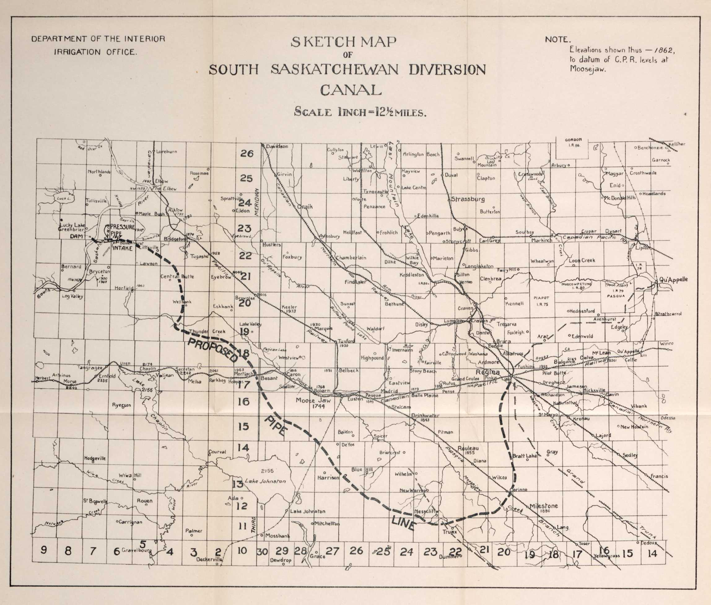 |
jpeg tif |
Saskatchewan | Canals Irrigation |
1 inch : 12.5 miles |
| 452 | Plan Of Current Meter Rating Station At Calgary | 1912 | Vol. 47, Issue 18 Sessional Paper # 35a |
 |
jpeg tif |
Calgary Alberta | Meter Rating | 1/8 inches : 1 foot |
| 453 | Details Of Car For Current Meter Rating Station At Calgary, Alberta | 1912 | Vol. 47, Issue 18 Sessional Paper # 35a |
 |
jpeg tif |
Calgary Alberta | Meter Rating | 1.5 inches : 1 foot |
| 454 | Details Of Car For Current Meter Rating Station At Calgary, Alberta | 1912 | Vol. 47, Issue 18 Sessional Paper # 35a |
 |
jpeg tif |
Calgary | Technical Drawings Meter Rating |
0.75 inches : 1 foot |
| 455 | Rating Curve For Gurleys Large Electric Meter Pattern No. 600 | 1912 | Vol. 47, Issue 18 Sessional Paper # 35a |
 |
jpeg tif |
Calgary | Electric Meter | no scale given |
| 456 | Rating Curve For Gurleys Large Electric Meter Pattern No. 600 Showing Revolutions Per Second And Velocity In Feet Per Second | 1912 | Vol. 47, Issue 18 Sessional Paper # 35a |
 |
jpeg tif |
Department Of The Interior | Gurleys Electric Meter |
no scale given |
| 457 | Rating Curve For Gurleys Large Electric Meter Pattern No. 600 Showing Revolutions Per Second And Velocity In Feet Per Second | 1912 | Vol. 47, Issue 18 Sessional Paper # 35a |
 |
jpeg tif |
Department Of The Interior | Electric Meter | no scale given |
| 458 | Rating Curve For Gurleys Small Electric Meter Pattern No. 618 Showing Revolutions Per Second And Velocity In Feet Per Second | 1912 | Vol. 47, Issue 18 Sessional Paper # 35a |
 |
jpeg tif |
Department Of The Interior | Electric Meter | no scale given |
| 459 | Map Of The Dominion Of Canada Shewing Astronomical Stations Established Up To 31st, March 1911 | 1911 | Vol. 47, Issue 19 Sessional Paper # 35a |
 |
jpeg tif |
Canada British Columbia Alberta Saskatchewan Manitoba Ontario Quebec Newfoundland Labrador New Brunswick Nova Scotia Prince Edward Island Yukon Northwest Territories |
Astronomy Astronomical Stations |
100 miles : 1 inch |
| 460 | Map Of The Dominion Of Canada Shewing Astronomical Stations Established Up To 31st, March 1911 | 1911 | Vol. 47, Issue 19 Sessional Paper # 35a |
 |
jpeg tif |
100 miles : 1 inch | ||
| 461 | Magnetic Declination Observed In 1910 | 1910 | Vol. 47, Issue 19 Sessional Paper # 35a |
 |
jpeg tif |
Saskatchewan Manitoba Ontario Lake Superior |
Magnetic Declination Navigation |
35 miles : 1 inch |
| 462 | Maps And Profiles To Accompany The Annual Report Of The Topographical Surveys Branch For 1911-1912 (Key) | 1912 | Vol. 47, Issue 19 Sessional Paper # 35a |
 |
jpeg tif |
Western Canada | Maps Topographical Surveys |
no scale given |
| 463 | Index To Townships In Manitoba, Saskatchewan, Alberta And British Columbia | 1913 | Vol. 47, Issue 19 Sessional Paper # 35a |
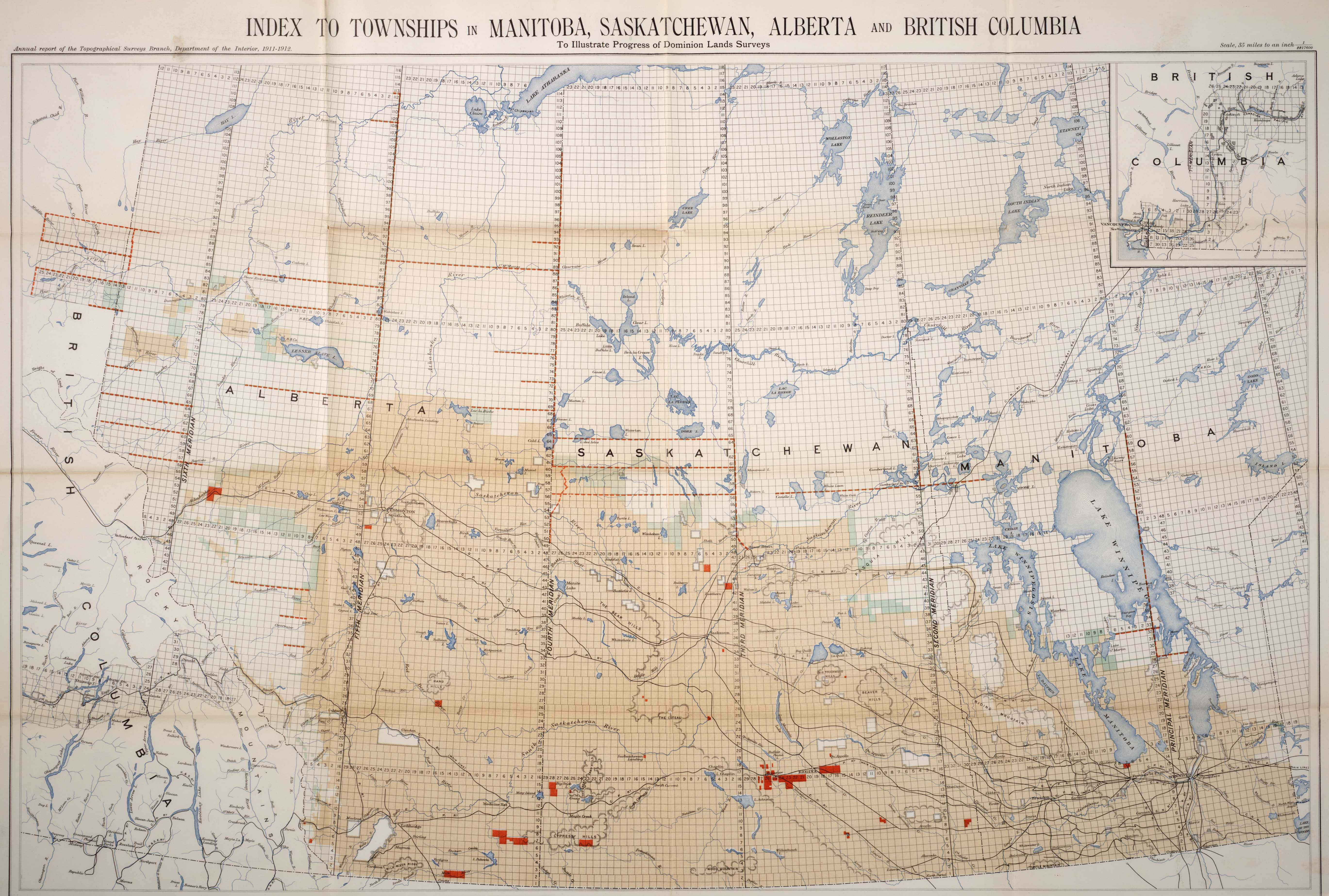 |
jpeg tif |
Canada British Columbia Alberta Saskatchewan Manitoba |
Land Surveys | 35 miles : 1 inch |
| 464 | Map Showing The Azimuth Of Magnetic North In Western Canada For January 1912 | 1913 | Vol. 47, Issue 19 Sessional Paper # 35a |
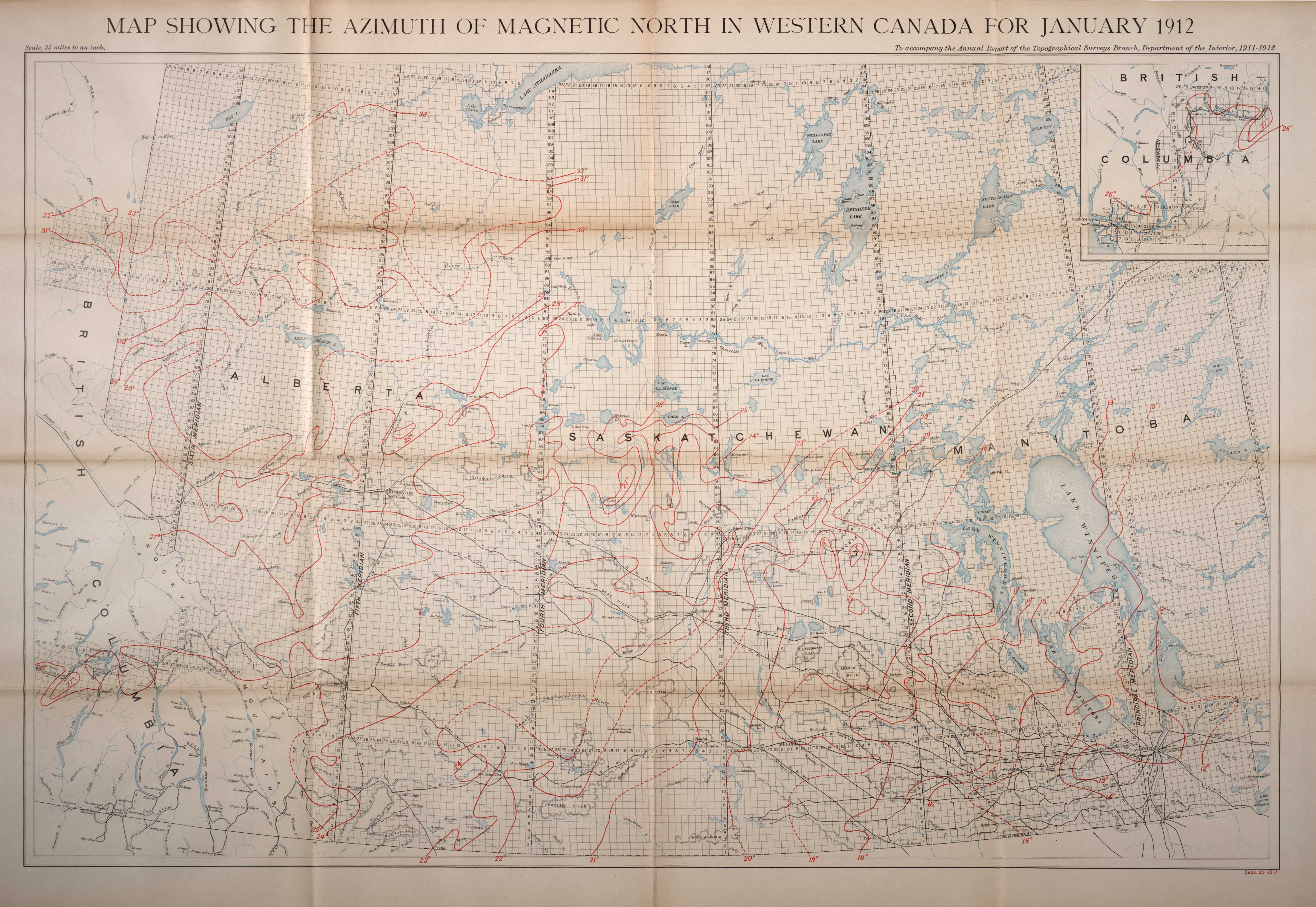 |
jpeg tif |
Canada British Columbia Alberta Saskatchewan Manitoba |
Magnetic Magnetic North |
35 miles : 1 inch |
| 465 | Map Showing Positions Of Magnetic Stations Occupied To December 31, 1911 | 1913 | Vol. 47, Issue 19 Sessional Paper # 35a |
 |
jpeg tif |
Canada British Columbia Alberta Saskatchewan Manitoba |
Magnetic Stations | 35 miles : 1 inch |
| 466 | Profile Along The Principal Meridian From Lake Winnipeg To Township 61 | 1912 | Vol. 47, Issue 19 Sessional Paper # 35a |
 |
jpeg tif |
Lake Winnipeg Township 61 |
Elevations | 6 miles : 1 inch |
| 467 | Sketch Map Of The Second Meridian From Township 62 To Township 67 | 1912 | Vol. 47, Issue 19 Sessional Paper # 35a |
 |
jpeg tif |
Second Meridian Amisk Lake |
Elevations | 6 miles : 1 inch |
| 468 | Sketch Map Of The Fifteenth Base Line Across Ranges 1 To 21 West Of Second Meridian | 1912 | Vol. 47, Issue 19 Sessional Paper # 35a |
 |
jpeg tif |
Second Meridian Fifteenth Base Line Cumberland Lake Saskatchewan River |
Elevations | 6 miles : 1 inch |
| 469 | Sketch Map Of The Third Meridian From The Sixteenth To Seventeenth Base Line, The Seventeenth Base Line From The Third To Fourth Meridian And The Fourth Meridian From Township 61 To Township 67 | 1912 | Vol. 47, Issue 19 Sessional Paper # 35a |
 |
jpeg tif |
Third Meridian Fourth Meridian Seventeenth Base Line Dore Lake Smoothstone Lake Montreal Lake Cold Lake |
Elevations | 6 miles : 1 inch |
| 470 | Sketch Map Of The Fourth Meridian From Township 95 To Township 105 And Of The Twenty-Fourth Base Line Across Ranges 1 To 4, West Of Fourth Meridian | 1912 | Vol. 47, Issue 19 Sessional Paper # 35a |
 |
jpeg tif |
Alberta Saskatchewan Fourth Meridian Twenty-Fourth Base Line Richardson River |
Elevations | 6 miles : 1 inch |
| 471 | Sketch Map Of The Twenty-Third Base Line Between Fourth And Fifth Meridians | 1912 | Vol. 47, Issue 19 Sessional Paper # 35a |
 |
jpeg tif |
Fifth Meridian Fourth Meridian Twenty-Third Base Line Clearwater River Athabaska River |
Elevations | 6 miles : 1 inch |
| 472 | Profile Along The Fifth Meridian From Township 71 To Township 112, The Twenty-Eighth Base Line Across Ranges 1 To 4 And The Twenty-Ninth Base Line Across Range 1, West Of The Fifth Meridian | 1912 | Vol. 47, Issue 19 Sessional Paper # 35a |
jpeg tif |
Fifth Meridian Twenty-Eighth Base Line Twenty-Ninth Base Line Fox Lake Trout River |
Elevations | 6 miles : 1 inch | |
| 473 | Sketch Map Of The Twenty-Second Base Line Across Ranges 1 To 20 West Of Fifth Meridian | 1912 | Vol. 47, Issue 19 Sessional Paper # 35a |
 |
jpeg tif |
Lubicon Lake Cadotte Lake Trout Lak Fifth Meridian Twenty-Second Base Line |
Elevations | 6 miles : 1 inch |
| 474 | Sketch Map Of The Sixteenth Base Line Across Ranges 5 To 13 And The Seventeenth Base Line Across Ranges 9 To 14 West Of Sixth Meridian | 1912 | Vol. 47, Issue 19 Sessional Paper # 35a |
 |
jpeg tif |
Porcupine River Sixth Meridian Sixteenth Base Line Seventeenth Base Line |
Elevations | 6 miles : 1 inch |
| 475 | Sketch Map Of The Twentieth Base Line Across Ranges 13 To 17, The Twenty-First Base Line Across Ranges 13 To 26 And The West Boundary Of Peace River Block From Township 77 To Township 80 West Of Sixth Meridian | 1912 | Vol. 47, Issue 19 Sessional Paper # 35a |
 |
jpeg tif |
Peace River Moberly Lake Sixth Meridian Twentieth Base Line Twenty-First Base Line Alberta |
Elevations | 6 miles : 1 inch |
| 476 | Sketch Map Of The Twenty-Second Base Line Across Ranges 13 To 26 And The East Boundary Of Tps. 83 And 84, Range 13 West Of Sixth Meridian | 1912 | Vol. 47, Issue 19 Sessional Paper # 35a |
 |
jpeg tif |
Peace River Charlie Lake Sixth Meridian Twenty-Second Base Line |
Elevations | 6 miles : 1 inch |
| 477 | Sketch Map Of The East Boundaries Of Townships 85 To 88, Range 13, The Twenty-Third Base Line From Range 10 To The West Boundary Of Alberta, The North Boundary Of Peace River Block And The West Boundary Of Peace River Block From Township 85 To Township 88, West Of Sixth Meridian | 1912 | Vol. 47, Issue 19 Sessional Paper # 35a |
 |
jpeg tif |
Peace River Twenty-Third Base Line Alberta |
Elevations | 6 miles : 1 inch |
| 478 | Sketch Map Of Part Of The Railway Belt British Columbia | 1912 | Vol. 47, Issue 19 Sessional Paper # 35a |
 |
jpeg tif |
Shuswap Mountains Shuswap Lake Mabel Lake Columbia River Illecillewaet River British Columbia |
Railway | 4 miles : 1 inch |
| 479 | Topographical Map Showing Mount Robson And Mountains Of The Continental Divide North Of Yellowhead Pass | 1911 | Vol. 47, Issue 19 Sessional Paper # 35a |
 |
jpeg tif |
Mount Robson Yellowhead Pass Rainbow Mountains |
Topographical Maps Topography |
printed on map |
| 480 | Outline Map Of The Dawson Mining District, Yukon Territory, Showing Location Of Some Quartz Deposits | 1913 | Vol. 47, Issue 20 Sessional Paper # 35a |
 |
jpeg tif |
Dawson Klondike River Yukon |
Gold Quartz Mining |
2 miles : 1 inch |
| 481 | Outline Map Of The Dawson Mining District, Yukon Territory, Showing Location Of Some Quartz Deposits | 1913 | Vol. 47, Issue 20 Sessional Paper # 35a |
 |
jpeg tif |
2 miles : 1 inch | ||
| 482 | Southern Portion Of Cranbrook Map-Area, East And West Kootenay, British Columbia | 1913 | Vol. 47, Issue 20 Sessional Paper # 35a |
 |
jpeg tif |
Kootenay Cranbrook |
Geological Survey Granite Limestone Devonian Carboniferous Cambrian Jurassic |
printed on map |
| 483 | Blairmore, Alberta | 1913 | Vol. 47, Issue 20 Sessional Paper # 35a |
 |
jpeg tif |
Blairmore Turtle Mountain Crowsnest River Lyon Creek Tallon Peak |
Geological Survey Granite Jurassic Cretaceous |
printed on map |
| 484 | Wanipigow, Manigotagan And Oiseau Rivers | 1912 | Vol. 47, Issue 20 Sessional Paper # 35a |
 |
jpeg tif |
Manigotagan Lake Manigotagan River Wanipigow River Oiseau River Winnipeg River Lac Du Bonnet |
Geological Survey Keweenawan Granite Pre-Cambrian Ordovician |
4 miles : 1 inch |
| 485 | Bell River Quebec | 1912 | Vol. 47, Issue 20 Sessional Paper # 35a |
 |
jpeg tif |
Bell River Pontiac Granet Pelissier Sabourin Marrias Bourlamaque Louvicourt Pascalis Senneville Fiedmont Courville Senneterre Montgay Carpentier Barraute Ducros Rochebeaucourt La Morandiere Vassal Despinassy Bartouille Abitibi Timiskaming |
Geological Survey Pleistocene Keweenawan Granite Pre-Cambrian |
8 miles : 1 inch |
| 486 | Nova Scotia No 13 | 1912 | Vol. 47, Issue 23 Sessional Paper # 35a |
 |
jpeg tif |
Nova Scotia | Proposed Settlements | printed on map |
| 487 | Hudson Bay: Nelson Roads | 1912 | Vol. 47, Issue 25 Sessional Paper # 35a |
 |
jpeg tif |
Nelson River Hudson Bay |
Water Obstacles Navigation |
printed on map |
| 488 | Chart Of Radio-Telegraph Coast Stations On The Great Lakes | Vol. 47, Issue 25 Sessional Paper # 35a |
 |
jpeg tif |
Great Lakes Lake Superior Lake Michigan Lake Huron Lake Ontario Lake Erie Georgian Bay Lake Simcoe Nottawasaga Bay Saginaw Bay Lake St. Clair Green Bay Apostle Islands |
Radio Stations Telegraph Stations Radio-Telegraph Stations |
printed on map | |
| 489 | Hudson Bay And Strait Showing The Path Of The H.S.S. Minto From Port Nelson | 1911 | Vol. 47, Issue 25 Sessional Paper # 35a |
 |
jpeg tif |
Hudson Bay Southampton Island Fox Land Nettilling Lake Amadjuak Lake Frobisher Bay Melville Peninsula |
H.S.S. Minto | 50 miles : 1 inch |
| 490 | Hudson Bay And Strait Showing The Path Of The H.S.S. Minto To Port Nelson | 1911 | Vol. 47, Issue 25 Sessional Paper # 35a |
 |
jpeg tif |
Hudson Bay Southampton Island Fox Land Nettilling Lake Amadjuak Lake Frobisher Bay Melville Peninsula |
H.S.S. Minto Arctic Expeditions |
50 miles : 1 inch |
| 491 | Frontispiece To Report Of Departmental Commission On Official Statistics Of Canada | 1912 | Vol. 47, Issue 6s Sessional Paper # 35a |
 |
jpeg tif |
Canada | Population Property Production Distribution Labour Finance Administration Demography |
no scale given |
| 492 | Frontispiece To Report Of Departmental Commission On Official Statistics Of Canada | 1912 | Vol. 47, Issue 6s Sessional Paper # 35a |
 |
jpeg tif |
no scale given | ||
| 493 | Maps To Accompany Part Vi Of The Annual Report Of The Department Of Trade And Commerce For The Fiscal Year Ending March 31st, 1913 | 1913 | Vol. 48, Issue 08 Sessional Paper # 35a |
 |
jpeg tif |
Quebec New Brunswick Nova Scotia Prince Edward Island |
Trade | no scale given |
| 494 | Map Of The Province Of British Columbia Shewing Routes, Mileage, Ports Of Call And Terminal Ports Of Steamship Lines Subsidized By The Dominion Government During The Fiscal Year, Correct To December 31st, 1913 | 1913 | Vol. 48, Issue 08 Sessional Paper # 35a |
 |
jpeg tif |
British Columbia | Ports Steamship Lines |
printed on map |
| 495 | Map Of The Provinces Of Quebec, New Brunswick, Nova Scotia, And Prince Edward Island Shewing Routes, Mileage, Ports Of Call And Terminal Ports Of Steamship Lines Subsidized By The Dominion Government During The Fiscal Year 1913-1914, Correct To December 31st, 1913 | 1913 | Vol. 48, Issue 08 Sessional Paper # 35a |
 |
jpeg tif |
Quebec New Brunswick Nova Scotia Prince Edward Island |
Ports Steamship Lines |
printed on map |
| 496 | Annual Report Of The Department Of Railways And Canals For 1913, Maps To Accompany Deputy Minister'S Report (Key) | 1913 | Vol. 48, Issue 14 Sessional Paper # 35a |
 |
jpeg tif |
Canada | Railways Canals |
no scale given |
| 497 | Map Showing Trent Navigation And Murray Canal | 1913 | Vol. 48, Issue 14 Sessional Paper # 35a |
 |
jpeg tif |
Simcoe York Ontario Victoria Durham Peterborough Northumberlan Hastings Prince Edward Addington Lennox |
Canals | 10 miles : 1 inch |
| 498 | Map Showing St. Lawrence, Ottawa, Rideau, And Richelieu Canals | 1913 | Vol. 48, Issue 14 Sessional Paper # 35a |
 |
jpeg tif |
Frontenac Lanark Leeds Carleton Grenville Russell Dundas Stormont Prescott Argenteuil Vaudreuil Glengarry Soulanges Huntingdon Chateauguay Beauharnois Two Mountains Laval La Prairie Napierville St. John Vercheres Chambly Richelieu St. Hyacinthe Rouville Iberville Missisquoi St. Lawrence River |
Canals | 10 miles : 1 inch |
| 499 | Map Of The Dominion Of Canada | 1913 | Vol. 48, Issue 14 Sessional Paper # 35a |
 |
jpeg tif |
Canada | Railways - Canada | printed on map |
| 500 | Map Showing Railways In The Northern Parts Of British Columbia And Alberta | 1913 | Vol. 48, Issue 14 Sessional Paper # 35a |
 |
jpeg tif |
British Columbia Alberta Queen Charlotte Islands |
Railways | printed on map |
| 501 | Map Showing Railways In Parts Of British Columbia And Alberta | 1913 | Vol. 48, Issue 14 Sessional Paper # 35a |
 |
jpeg tif |
British Columbia Alberta Vancouver Island |
Railways | printed on map |
| 502 | Map Showing Railways In Manitoba, Saskatchewan, And Alberta | 1913 | Vol. 48, Issue 14 Sessional Paper # 35a |
 |
jpeg tif |
Saskatchewan Manitoba Alberta Lake Winnipeg |
Railways | printed on map |
| 503 | Map Showing Railways In Parts Of Ontario And Manitoba | 1913 | Vol. 48, Issue 14 Sessional Paper # 35a |
 |
jpeg tif |
Ontario Lake Superior |
Canadian Pacific System Canadian Northern System National Transcontinental Railway Grand Trunk System Railways |
printed on map |
| 504 | Map Showing Railways In Parts Of Ontario And Quebec | 1913 | Vol. 48, Issue 14 Sessional Paper # 35a |
 |
jpeg tif |
Ontario Quebec Lake Michigan Lake Huron Lake Erie Lake Ontario Georgian Bay |
Railways | printed on map |
| 505 | Map Showing Railways In Nova Scotia, New Brunswick, P. E. Island, And Part Of Quebec | 1913 | Vol. 48, Issue 14 Sessional Paper # 35a |
 |
jpeg tif |
Nova Scotia New Brunswick Prince Edward Island Quebec Cape Breton Island |
Railways | printed on map |
| 506 | Map Showing Canadian Ship Canal Also St. Mary'S Falls Canal Mich, U.S.A. | 1913 | Vol. 48, Issue 14 Sessional Paper # 35a |
 |
jpeg tif |
Lake Ontario Sault Ste. Marie St. Mary'S River Whitefish Island |
Canals Shipping |
printed on map |
| 507 | Map Showing Line Of Welland Canal Between Lakes Erie & Ontario | 1913 | Vol. 48, Issue 14 Sessional Paper # 35a |
 |
jpeg tif |
Lake Erie Lake Ontario Sherbrooke Moulton Wainfleet Gainsboro Louth Pelha Thorold Humberstone Crowland Stamford Grantham Niagara |
Canals | printed on map |
| 508 | Hudson Bay Railway Map Showing Railway Location From The Pas To Hudson Bay | 1913 | Vol. 48, Issue 14 Sessional Paper # 35a |
 |
jpeg tif |
Hudson Bay Pas |
Railways | 1 inch : 10 miles |
| 509 | Quebec Bridge Across River St. Lawrence Above Quebec | 1914 | Vol. 48, Issue 14 Sessional Paper # 35a |
 |
jpeg tif |
Quebec Bridge | Bridges | printed on map |
| 510 | Proposed Route Of The New Welland Ship Canal | 1914 | Vol. 48, Issue 14 Sessional Paper # 35a |
 |
jpeg tif |
Welland Lake Erie Lake Ontario |
Canals | no scale given |
| 511 | Profile Of Lock Section Of New Welland Ship Canal | 1914 | Vol. 48, Issue 14 Sessional Paper # 35a |
 |
jpeg tif |
Welland Thorold |
Canals Dams Locks |
no scale given |
| 512 | Department Of The Interior - Key To Maps | 1913 | Vol. 48, Issue 19 Sessional Paper # 35a |
 |
jpeg tif |
British Columbia | Topographical Surveys | no scale given |
| 513 | Index To Townships In Manitoba, Saskatchewan, Alberta, And British Columbia | 1913 | Vol. 48, Issue 19 Sessional Paper # 35a |
 |
jpeg tif |
Manitoba Saskatchewan Alberta British Columbia |
Topography Topographical Surveys |
35 miles : 1 inch |
| 514 | Sketch Map Of Part Of The Railway Belt British Columbia | 1913 | Vol. 48, Issue 19 Sessional Paper # 35a |
 |
jpeg tif |
British Columbia Shuswap Lake |
Topographical Surveys | 4 miles : 1 inch |
| 515 | Sketch Map Of Part Of The Railway Belt British Columbia | 1913 | Vol. 48, Issue 19 Sessional Paper # 35a |
 |
jpeg tif |
British Columbia Illecillewaet Columbia River |
Topographical Surveys | 4 miles : 1 inch |
| 516 | Annual Report Of The Topographical Surveys Branch, Maps 12 To 16 | 1913 | Vol. 48, Issue 19 Sessional Paper # 35a |
jpeg tif |
Third Meridian Tenth Base Line Eleventh Base Line Twelfth Base Line Thirteenth Base Line Fourteenth Base Line |
Rivers Lakes Forest Topographical Surveys |
1,000 feet : 1 inch | |
| 517 | Annual Report Of The Topographical Surveys Branch, Map 13 & 14 | 1913 | Vol. 48, Issue 19 Sessional Paper # 35a |
jpeg tif |
Nineteenth Base Line Twenty-Third Base Line |
Rivers Lakes Topographical Surveys |
1000 feet : 1 inch | |
| 518 | Annual Report Of The Topographical Surveys Branch, Maps 4 To 11 | 1913 | Vol. 48, Issue 19 Sessional Paper # 35a |
 |
jpeg tif |
Fourth Meridian Principal Meridian Sixth Meridian Twentieth Base Line Twenty-Second Base Line Twenty-Third Base Line Twenty-Fourth Base Line Alberta |
Rivers Lakes Forest |
1000 feet : 1 inch |
| 519 | Map Showing Gauging Stations In Alberta And Saskatchewan | 1913 | Vol. 48, Issue 20 Sessional Paper # 35a |
 |
jpeg tif |
Alberta Saskatchewan Manitoba |
Gauging Stations Irrigation Canals |
35 miles : 1 inch |
| 520 | Manitoba Power Survey Map Shewing Water Powers Of Southern Manitoba | 1913 | Vol. 48, Issue 21 Sessional Paper # 35a |
 |
jpeg tif |
Manitoba Lake Winnipeg |
Water Power Water Flow |
printed on map |
| 521 | Water Power Branch, Dept Of The Interior | Vol. 48, Issue 21 Sessional Paper # 35a |
 |
jpeg tif |
Fraser River Columbia River Shuswap River Thompson River Port Moody Kamloops Sicamous Seymour Donald Spillimacheen British Columbia |
River Drainage Water Power |
35 miles : 1 inch | |
| 522 | Donald Sheet | Vol. 48, Issue 21 Sessional Paper # 35a |
 |
jpeg tif |
Columbia River Donald |
River Drainage Water Power |
6 miles : 1 inch | |
| 523 | Spillimacheen Sheet | 1913 | Vol. 48, Issue 21 Sessional Paper # 35a |
 |
jpeg tif |
Columbia River Spillimacheen |
River Drainage Water Power |
6 miles : 1 inch |
| 524 | Sicamous Sheet | 1913 | Vol. 48, Issue 21 Sessional Paper # 35a |
 |
jpeg tif |
Columbia River Shuswap Lake Thompson River Sicamous |
River Drainage Water Power |
6 miles : 1 inch |
| 525 | Kamloops Sheet | 1913 | Vol. 48, Issue 21 Sessional Paper # 35a |
 |
jpeg tif |
Fraser River Thompson River Kamloops |
River Drainage Water Power |
6 miles : 1 inch |
| 526 | Lytton Sheet | 1913 | Vol. 48, Issue 21 Sessional Paper # 35a |
 |
jpeg tif |
Fraser River Thompson River Lytton |
River Drainage Water Power |
6 miles : 1 inch |
| 527 | Yale Sheet | 1913 | Vol. 48, Issue 21 Sessional Paper # 35a |
 |
jpeg tif |
Yale Fraser River |
River Drainage Water Power |
6 miles : 1 inch |
| 528 | Port Moody Sheet | 1913 | Vol. 48, Issue 21 Sessional Paper # 35a |
 |
jpeg tif |
Port Moody Fraser River |
River Drainage Water Power |
6 miles : 1 inch |
| 529 | Water Power Branch, Dept Of The Interior | 1913 | Vol. 48, Issue 21 Sessional Paper # 35a |
 |
jpeg tif |
Fraser River Columbia River Shuswap River Thompson River Port Moody Kamloops Sicamous Seymour Donald Spillimacheen British Columbia |
River Drainage Water Power |
35 miles : 1 inch |
| 530 | Donald Sheet | 1913 | Vol. 48, Issue 21 Sessional Paper # 35a |
 |
jpeg tif |
Columbia River Donald |
River Drainage Water Power |
6 miles : 1 inch |
| 531 | Spillimacheen Sheet | 1913 | Vol. 48, Issue 21 Sessional Paper # 35a |
 |
jpeg tif |
Columbia River Spillimacheen |
River Drainage Water Power |
6 miles : 1 inch |
| 532 | Sicamous Sheet | 1913 | Vol. 48, Issue 21 Sessional Paper # 35a |
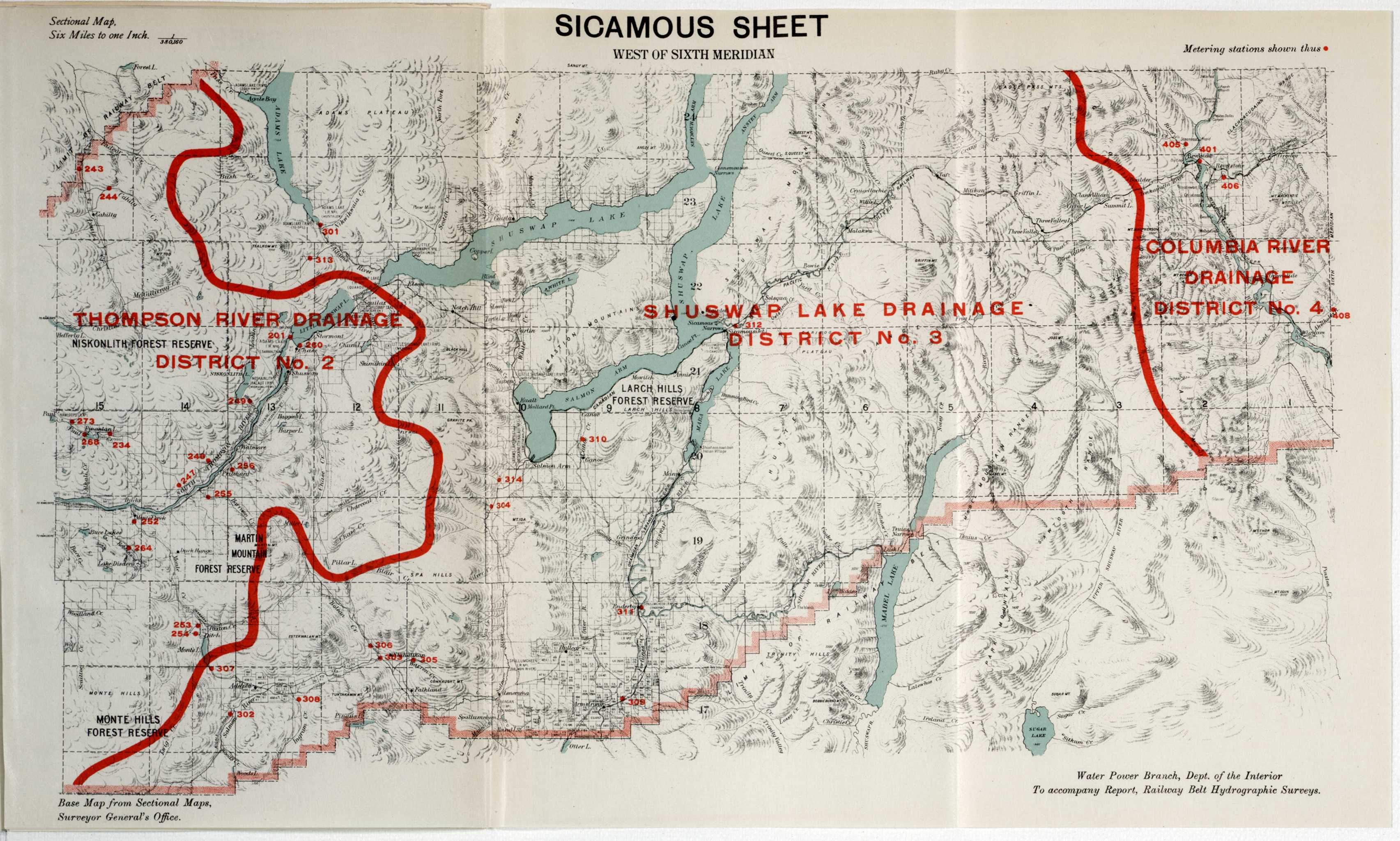 |
jpeg tif |
Columbia River Shuswap River Thompson River Sicamous |
River Drainage Water Power |
6 miles : 1 inch |
| 533 | Kamloops Sheet | 1913 | Vol. 48, Issue 21 Sessional Paper # 35a |
 |
jpeg tif |
Fraser River Thompson River Kamloops |
River Drainage Water Power |
6 miles : 1 inch |
| 534 | Lytton Sheet | 1913 | Vol. 48, Issue 21 Sessional Paper # 35a |
 |
jpeg tif |
Fraser River Thompson River Lytton |
River Drainage Water Power |
6 miles : 1 inch |
| 535 | Yale Sheet | 1913 | Vol. 48, Issue 21 Sessional Paper # 35a |
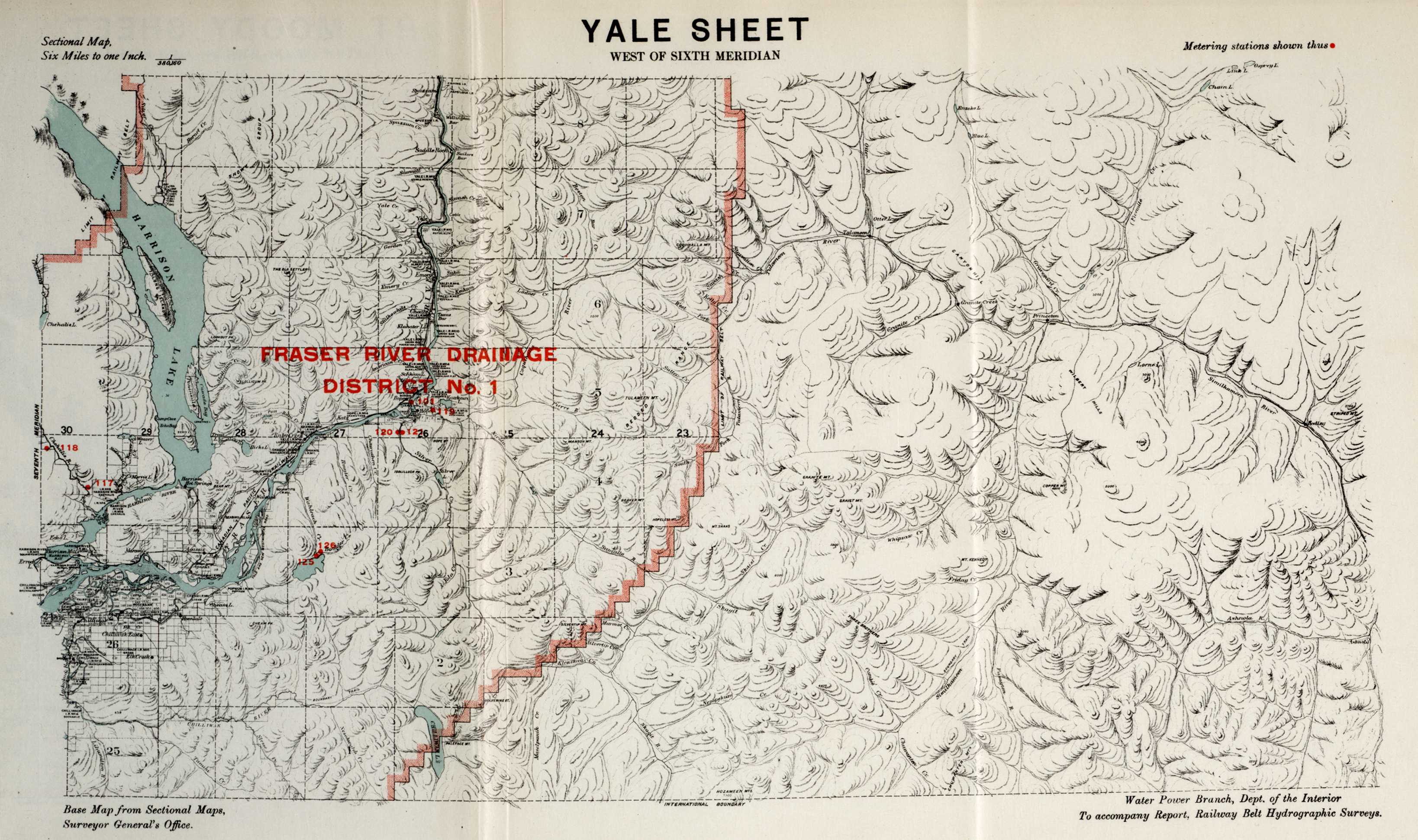 |
jpeg tif |
Yale Fraser River |
River Drainage Water Flow |
6 miles : 1 inch |
| 536 | Port Moody Sheet | 1913 | Vol. 48, Issue 21 Sessional Paper # 35a |
 |
jpeg tif |
Port Moody Fraser River |
River Drainage Water Power |
6 miles : 1 inch |
| 537 | Port De Louisbourg | 1800 | Vol. 48, Issue 25 Sessional Paper # 35a |
 |
jpeg tif |
Bastion Du Roy Bastion De La Reine Demi Bastion De La Reine Magaxin Du Roy Bastion Braullan Bastion Maurepas Demi Bastion Dauphin Veue De Louisbourg |
Louisbourg Colony Isle Royale |
printed on map |
| 538 | Plan By Order Of His Excellency Guy Lord Dorchester, Captain General & Governor In Chief Of The Provinces Of Upper & Lower Canada | 1795 | Vol. 48, Issue 25 Sessional Paper # 35a |
 |
jpeg tif |
Montreal Quebec |
Rivers Land Surveys |
4 miles : 1 inch |
| 539 | Plan By Order Of His Excellency Guy Lord Dorchester, Captain General & Governor In Chief Of The Provinces Of Upper & Lower Canada | 1795 | Vol. 48, Issue 25 Sessional Paper # 35a |
 |
jpeg tif |
Montreal Quebec |
Rivers Land Surveys |
4 miles : 1 inch |
| 540 | Plan Of The Province Of Upper Canada Divided Into Counties | 1793 | Vol. 48, Issue 25 Sessional Paper # 35a |
 |
jpeg tif |
Upper Canada Canada Ontario |
County Borders | 10 miles : 3/4 inch |
| 541 | Plan By Order Of His Excellency Guy Lord Dorchester<, Captain General & Governor In Chief Of The Provinces Of Upper & Lower Canad | 1795 | Vol. 48, Issue 25 Sessional Paper # 35a |
 |
jpeg tif |
Montreal Quebec |
Rivers County Boundaries |
4 miles : 1 inch |
| 542 | (Boundary Between Provinces Of Upper And Lower Canada) | 1791 | Vol. 48, Issue 25 Sessional Paper # 35a |
 |
jpeg tif |
Rigaud Newton New Longueud Vaudreuil Soulange Lake Of Two Mountains Isle Perrault Upper Canada Lower Canada Quebec Ontario |
Provincial Borders | 9 miles : 1 inch |
| 543 | Lines Of Equal Magnetic Declination In Eastern Canada | 1912 | Vol. 48, Issue 27 Sessional Paper # 35a |
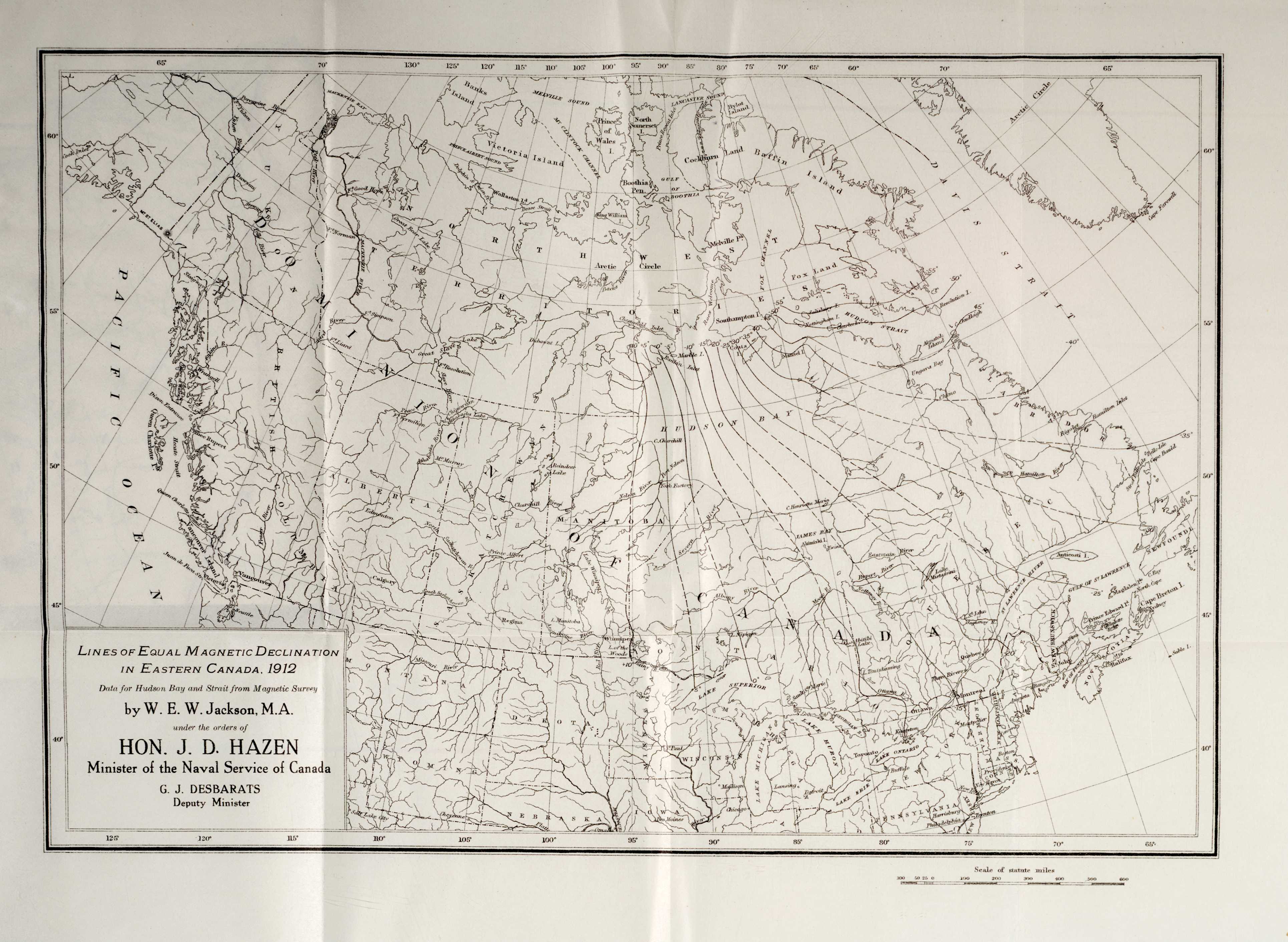 |
jpeg tif |
Canada | Magnetic Survey Magnetic Declination |
100 miles : 1 inch |
| 544 | Map Of Wireless Telegraph Coast Stations Of The Dominion Of Canada | 1913 | Vol. 48, Issue 27 Sessional Paper # 35a |
 |
jpeg tif |
Canada | Telegraph Stations Wireless Telegraph |
100 miles : 1 inch |
| 545 | The National Transcontinental Railway: Eastern Division - Standard Station Yard | 1906 | Vol. 48, Issue 28 Sessional Paper # 35a |
 |
jpeg tif |
Canada | Railways | 100 feet : 1 inch |
| 546 | The Commisioners Of The Transcontinental Railway: District "B" Approximate Estimate Of Cost Of Construction | 1913 | Vol. 48, Issue 28 Sessional Paper # 35a |
 |
jpeg tif |
Quebec | Railway Construction | no scale given |
| 547 | The Commisioners Of The Transcontinental Railway: District "B" Approximate Estimate Of Cost Of Construction | 1913 | Vol. 48, Issue 28 Sessional Paper # 35a |
 |
jpeg tif |
Quebec | Railway Construction | no scale given |
| 548 | The National Transcontinental Railway: District "F" | 1906 | Vol. 48, Issue 28 Sessional Paper # 35a |
 |
jpeg tif |
Canada | Railway Construction Costs | no scale given |
| 549 | The National Transcontinental Railway: District "F" Approximate Estimate Of Cost Of Construction | 1906 | Vol. 48, Issue 28 Sessional Paper # 35a |
 |
jpeg tif |
Canada | Railway Construction | no scale given |
| 550 | The National Transcontinental Railway: District "F" Approximate Estimate Of Cost Of Construction | 1906 | Vol. 48, Issue 28 Sessional Paper # 35a |
 |
jpeg tif |
Canada | Railway Construction | no scale given |
| 551 | The National Transcontinental Railway: District "B" Approximate Estimate Of Cost Of Construction | 1906 | Vol. 48, Issue 28 Sessional Paper # 35a |
 |
jpeg tif |
Canada | Railway Construction | no scale given |
| 552 | The National Transcontinental Railway: District "B" Approximate Estimate Of Cost Of Construction | 1906 | Vol. 48, Issue 28 Sessional Paper # 35a |
 |
jpeg tif |
Canada | Railway Construction | no scale given |
| 553 | The National Trans-Continental Railway Eastern Divsion District "B" Party "4" Plan Of Projected Lines "A" And "B" | 1906 | Vol. 48, Issue 28 Sessional Paper # 35a |
 |
jpeg tif |
Quebec | Bridges Railway Construction |
400 feet : 1 inch |
| 554 | The National Trans-Continental Railway Eastern Divsion District "B" Party "4" Plan Of Projected Lines "A" And "B" | 1906 | Vol. 48, Issue 28 Sessional Paper # 35a |
 |
jpeg tif |
Quebec | Bridges Railway Construction |
400 feet : 1 inch |
| 555 | N. T. Ry. Profile - Projected "Line A" | 1912 | Vol. 48, Issue 28 Sessional Paper # 35a |
 |
jpeg tif |
Quebec | Bridges Railway Construction |
400 feet : 1 inch |
| 556 | National Transcontinental Railway Map: Showing General Grading Contracts | 1913 | Vol. 48, Issue 28 Sessional Paper # 35a |
 |
jpeg tif |
Ontario Quebec New Brunswick Nova Scotia Prince Edward Island Manitoba |
Railways Grading Contracts |
1 inch : 60 miles |
| 557 | National Transcontinental Railway: Eastern Division - Condensed Profile Showing Divisional Points And Heaviest Grades | 1913 | Vol. 48, Issue 28 Sessional Paper # 35a |
 |
jpeg tif |
Manitoba Ontario Quebec New Brunswick |
Railways | printed on map |
| 558 | Wireless Meteorological Information | 1913 | Vol. 48, Issue 28 Sessional Paper # 35a |
 |
jpeg tif |
North Atlantic Ocean Labrador Newfoundland Nova Scotia New Brunswick Quebec Greenland Iceland United Kingdom Ireland Spain Portugal |
Meteorological Information Meteorological Survey |
no scale given |
| 559 | Railway Grain Routes - Map Showing The Quantity Of Grain Hauled By The Different Railroads - Cars - Bushels | 1914 | Vol. 50, Issue 07 Sessional Paper # 35a |
 |
jpeg tif |
Canada | Railways Grain Transportation Grain Routes |
200 miles : 1 inch |
| 560 | West St. John Harbour, N.B., Beach Bar Wharves Looking East | 1914 | Vol. 50, Issue 13 Sessional Paper # 35a |
 |
jpeg tif |
St. John Harbour | Photo Wharves |
no scale given |
| 561 | West St. John Harbour, N.B.,Beacon Bar Wharves Looking South East | 1914 | Vol. 50, Issue 13 Sessional Paper # 35a |
 |
jpeg tif |
St. John Harbour | Photo Wharves |
no scale given |
| 562 | Harbour Of Saint John N.B. | 1914 | Vol. 50, Issue 13 Sessional Paper # 35a |
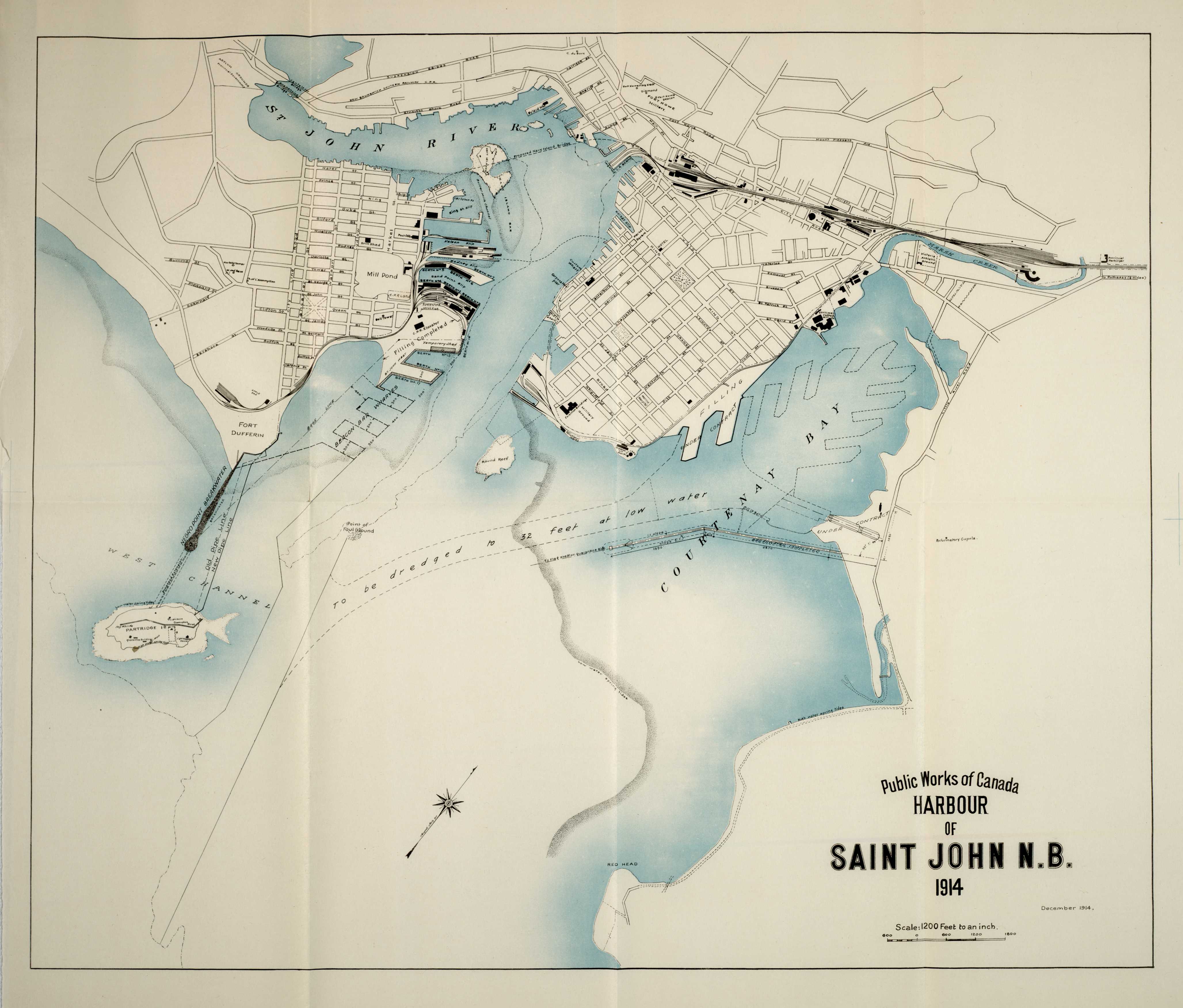 |
jpeg tif |
Saint John, New Brunswick Courtenay Bay St. John River |
Public Works Of Canada | 1200 feet : 1 inch |
| 563 | Annual Report Of The Department Of Railways And Canals For 1913-14, Maps To Accompany Deputy Minister'S Report (Key) | 1914 | Vol. 50, Issue 14 Sessional Paper # 35a |
 |
jpeg tif |
Canada | Railways Canals |
no scale given |
| 564 | Map Showing Trent Navigation And Murray Canal | 1914 | Vol. 50, Issue 14 Sessional Paper # 35a |
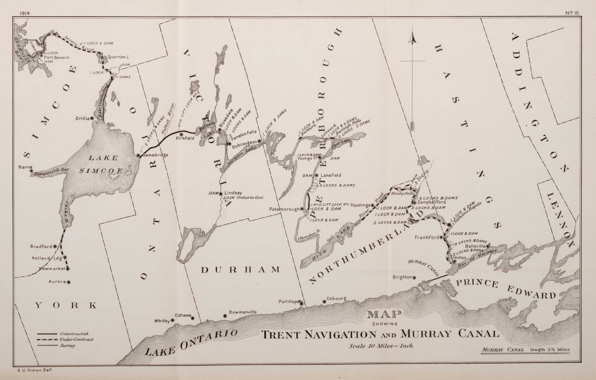 |
jpeg tif |
Simcoe York Ontario Victoria Durham Peterborough Hastings Addington Lennox Prince Edward Lake Ontario Lake Simcoe |
Canals | 10 miles : 1 inch |
| 565 | Map Showing St. Lawrence, Ottawa, Rideau And Richelieu Canals | 1914 | Vol. 50, Issue 14 Sessional Paper # 35a |
 |
jpeg tif |
Frontenac Lanark Leeds Carleton Grenville Dundas Russell Stormont Prescott Glengarry Argenteuil Vaudreuil Soulanges Huntingdon Chateauguay Beauharnois Two Mountains Laval Chambly La Prairie Vercheres St. Hyacinthe Rouville Iberville Missisquoi St. John Napierville Richelieu St. Lawrence River Ottawa River |
Canals | 10 miles : 1 inch |
| 566 | Map Of The Dominion Of Canada | 1914 | Vol. 50, Issue 14 Sessional Paper # 35a |
 |
jpeg tif |
Canada | Railways | printed on map |
| 567 | Map Showing Railways In The Northern Parts Of British Columbia And Alberta | 1914 | Vol. 50, Issue 14 Sessional Paper # 35a |
 |
jpeg tif |
British Columbia Alberta |
Railways | printed on map |
| 568 | Map Showing Railways In Parts Of British Columbia And Alberta | 1914 | Vol. 50, Issue 14 Sessional Paper # 35a |
 |
jpeg tif |
British Columbia Alberta |
Railways | printed on map |
| 569 | Map Showing Railways In Manitoba, Saskatchewan, And Alberta | 1914 | Vol. 50, Issue 14 Sessional Paper # 35a |
 |
jpeg tif |
Manitoba Saskatchewan Alberta |
Railways | printed on map |
| 570 | Map Showing Railways In Parts Of Ontario And Manitoba | 1914 | Vol. 50, Issue 14 Sessional Paper # 35a |
 |
jpeg tif |
Ontario Manitoba Lake Superior |
Railways | printed on map |
| 571 | Map Showing Railways In Parts Of Ontario And Quebec | 1914 | Vol. 50, Issue 14 Sessional Paper # 35a |
 |
jpeg tif |
Ontario Quebec Lake Michigan Lake Erie Georgian Bay Lake Ontario Lake Huron |
Railways | printed on map |
| 572 | Map Showing Railways In Nova Scotia, New Brunswick, P. E. Island, And Part Of Quebec | 1914 | Vol. 50, Issue 14 Sessional Paper # 35a |
 |
jpeg tif |
Nova Scotia New Brunswick Prince Edward Island Quebec |
Railways | printed on map |
| 573 | Map Showing Canadian Ship Canal Also St. Mary'S Falls Canal Mich, U.S.A. | 1914 | Vol. 50, Issue 14 Sessional Paper # 35a |
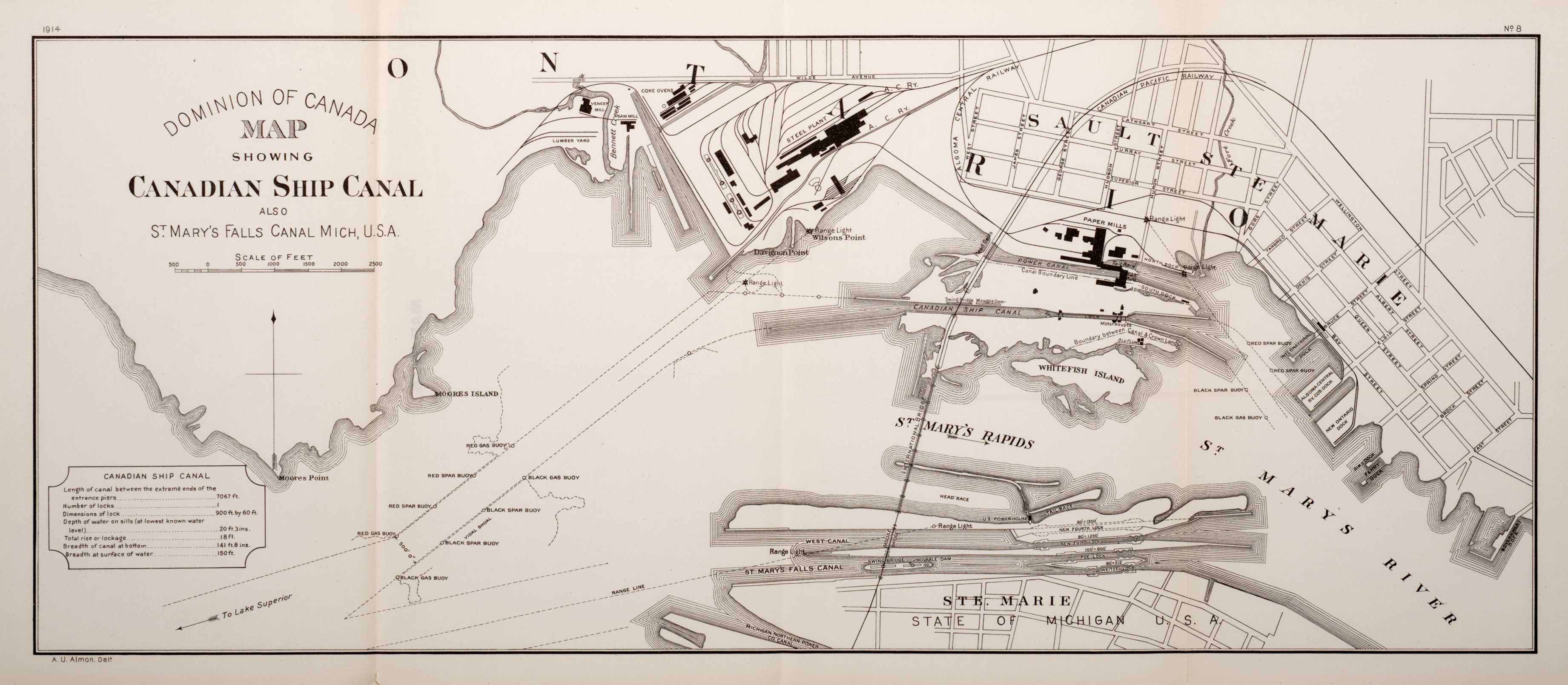 |
jpeg tif |
St. Mary'S Falls Canal Sault Ste Marie St. Mary'S River St. Mary'S Rapids |
Canals Shipping |
printed on map |
| 574 | Map Showing Line Of Welland Canal Between Lakes Erie & Ontario | 1914 | Vol. 50, Issue 14 Sessional Paper # 35a |
 |
jpeg tif |
Welland Canal Lake Erie Lake Ontario Sherbrooke Moulton Wainfleet Gainsboro Pelham Humberstone Louth Thorold Crowland Stamford Grantham Niagara |
Canals Shipping |
printed on map |
| 575 | Niagara Peninsula Plan Showing Location Of Welland Ship Canal | 1914 | Vol. 50, Issue 14 Sessional Paper # 35a |
 |
jpeg tif |
Niagara Niagara Peninsula Welland Ship Canal |
Canals Shipping |
printed on map |
| 576 | Intercolonial Railway Sketch Map Showing Terminals And Branches At Halifax, N.S. | 1914 | Vol. 50, Issue 14 Sessional Paper # 35a |
 |
jpeg tif |
Halifax Halifax Habour Nova Scotia |
Railways Shipping |
printed on map |
| 577 | Hudson Bay Railway: Map Showing Railway Location From The Pas To Hudson Bay | 1914 | Vol. 50, Issue 14 Sessional Paper # 35a |
 |
jpeg tif |
Hudson Bay | Railways | 1 inch : 10 miles |
| 578 | The Welland Ship Canal | 1914 | Vol. 50, Issue 14 Sessional Paper # 35a |
 |
jpeg tif |
St. Catharines Welland Ship Canal Lake Erie Lake Ontario |
Canals Ship Canals |
printed on map |
| 579 | Irrigation Map And Plans To Accompany The Annual Report Of The Department Of The Interior (Key) | 1914 | Vol. 50, Issue 19 Sessional Paper # 35a |
 |
jpeg tif |
Alberta Saskatchewan |
Irrigation | no scale given |
| 580 | Map Showing Irrigation Schemes In Alberta And Saskatchewan | 1913 | Vol. 50, Issue 19 Sessional Paper # 35a |
 |
jpeg tif |
Alberta Saskatchewan |
Irrigation | 35 miles : 1 inch |
| 581 | Plan Of Surveys Completed 1913 In Cypress Hills | 1913 | Vol. 50, Issue 19 Sessional Paper # 35a |
jpeg tif |
Cypress Hills Old Man On His Back Plateau |
Irrigation | 3 miles : 1 inch | |
| 582 | Key Plan Showing Preliminary Surveys Of Oldman River Diversion Canal | 1913 | Vol. 50, Issue 19 Sessional Paper # 35a |
 |
jpeg tif |
Oldman River Alberta |
Canals | 1 inch: 4 miles |
| 583 | Studies In Duty Of Water And Climatic Conditions | 1913 | Vol. 50, Issue 19 Sessional Paper # 35a |
 |
jpeg tif |
Alberta Montana Saskatchewan |
Water Climate |
no scale given |
| 584 | Map Showing Preliminary Location Of Proposed Pipe Lines To Divert Water From South Saskatchewan River To Moose Jaw And Regina | 1914 | Vol. 50, Issue 19 Sessional Paper # 35a |
 |
jpeg tif |
Saskatchewan River Regina Moose Jaw |
Pipe Lines Water |
6 miles : 1 inch |
| 585 | Pasquia Reclamation Project, Saskatchewan River, Profile Of Proposed Canals, Cedar Lake To Cross Lake | 1914 | Vol. 50, Issue 19 Sessional Paper # 35a |
 |
jpeg tif |
Saskatchewan River Cedar Lake Cross Lake |
Water Power Canals |
printed on map |
| 586 | Key Plan Showing Location And Cross Section Of Test Borings Made During Winter Of 1913-14 | 1914 | Vol. 50, Issue 19 Sessional Paper # 35a |
 |
jpeg tif |
South Saskatchewan River | Irrigation | 3 miles : 1 inch |
| 587 | Key Plan Showing Location And Cross Section Of Test Borings Made During Winter Of 1913-14 | 1914 | Vol. 50, Issue 19 Sessional Paper # 35a |
 |
jpeg tif |
South Saskatchewan River | Test Borings Irrigation |
3 miles : 1 inch |
| 588 | Key Plan Showing Location And Cross Section Of Test Borings Made During Winter Of 1913-1914 | 1914 | Vol. 50, Issue 19 Sessional Paper # 35a |
 |
jpeg tif |
South Saskatchewan River | Irrigation | 3 miles : 1 inch |
| 589 | Canada Physiographic Provinces | 1914 | Vol. 50, Issue 21 Sessional Paper # 35a |
 |
jpeg tif |
Canadian Cordillera Great Plains Canadian Shield Appalacian Region Rocky Mountains Canada |
Physiography Physical Geography |
250 miles : 1 inch |
| 590 | Maps And Plates Accompanying Report On The Bow River Power And Storage Investigations (Key) | 1914 | Vol. 50, Issue 21 Sessional Paper # 35a |
 |
jpeg tif |
Bow River | Water Power Water |
no scale given |
| 591 | Contour Map Of Bow River Basin Above Calgary | 1912 | Vol. 50, Issue 21 Sessional Paper # 35a |
 |
jpeg tif |
Bow River Bow River Basin Yoho Park Rocky Mountains Rocky Mountains Park Alberta |
Water Power Water Flow |
4 miles : 1 inch |
| 592 | Key Map Of Bow River Basin Above Calgary | 1914 | Vol. 50, Issue 21 Sessional Paper # 35a |
 |
jpeg tif |
Bow River Bow River Basin Yoho Park Rocky Mountains Rocky Mountains Park Alberta |
Water Power Water Flow |
4 miles : 1 inch |
| 593 | Geological And Topographical Map Of The Moose Mountain Region Of The "Disturbed Belt", Southern Alberta | 1914 | Vol. 50, Issue 21 Sessional Paper # 35a |
 |
jpeg tif |
Southern Alberta Alberta Moose Mountain |
Geological Survey | 2 miles : 1 inch |
| 594 | Route Map Between Calgary And Banff | 1914 | Vol. 50, Issue 21 Sessional Paper # 35a |
 |
jpeg tif |
Calgary Banff Bow River |
Geological Survey | printed on map |
| 595 | Structure Section Across The Rocky Mountains Near The Main Line Of The Canadian Pacific Railway Between The Cascade Trough And The Columbia Valley | 1914 | Vol. 50, Issue 21 Sessional Paper # 35a |
 |
jpeg tif |
Cascade Trough Columbia Valley Rocky Mountains |
Stone Rock Pre-Cambrian Cambrian Ordovician Silurian Devonian Carboniferous Permian Jurassic Cretaceous Quaternary Canadian Pacific Railway Geological Survey |
printed on map |
| 596 | Diagram Showing Daily Discharge In Second-Feet Of The Bow River And Mean Daily Temperature In Degrees Fahrenheit From April 1910 To December 1912 As Recorded At Banff, Alta. | 1912 | Vol. 50, Issue 21 Sessional Paper # 35a |
 |
jpeg tif |
Bow River Banff Alberta |
Temperature Records | no scale given |
| 597 | Bow River Power And Storage Surveys, Profile Of Bow River Kananaskis Falls To Radnor | 1913 | Vol. 50, Issue 21 Sessional Paper # 35a |
 |
jpeg tif |
Bow Rivre Kananaskis Falls Radnor |
Water Power Water Storage |
printed on map |
| 598 | Bow River Power And Storage Surveys, Topographic Sheet No. 10 | 1913 | Vol. 50, Issue 21 Sessional Paper # 35a |
 |
jpeg tif |
Bow River | Water Power Water Storage |
printed on map |
| 599 | Bow River Power And Storage Surveys, Topographic Sheet No. 11 | 1913 | Vol. 50, Issue 21 Sessional Paper # 35a |
 |
jpeg tif |
Bow River | Water Power Water Storage |
printed on map |
| 600 | Bow River Power And Storage Surveys Plan Showing Proposed Development At Ghost Site | 1913 | Vol. 50, Issue 21 Sessional Paper # 35a |
 |
jpeg tif |
Bow River Ghost River |
Water Power Water Storage |
printed on map |
| 601 | Bow River Power And Storage Surveys Ghost Site, Topographic Sheet No. 12 | 1913 | Vol. 50, Issue 21 Sessional Paper # 35a |
 |
jpeg tif |
Bow River Ghost River |
Water Power Water Storage |
printed on map |
| 602 | Bow River Power And Storage Surveys Plan Showing Proposed Development At Radnor Site | 1913 | Vol. 50, Issue 21 Sessional Paper # 35a |
 |
jpeg tif |
Bow River Radnor |
Water Power Water Storage |
printed on map |
| 603 | Bow River Power And Storage Surveys Radnor Site, Topographic Sheet No. 13 | 1913 | Vol. 50, Issue 21 Sessional Paper # 35a |
 |
jpeg tif |
Bow River Radnor |
Water Power Water Storage |
printed on map |
| 604 | Bow River Power And Storage Surveys, Topographic Sheet No. 14 | 1913 | Vol. 50, Issue 21 Sessional Paper # 35a |
 |
jpeg tif |
Bow River | Water Power Water Storage |
printed on map |
| 605 | Bow River Power And Storage Surveys Ghost River Storage Site, Topographic Sheet No. 15 | 1913 | Vol. 50, Issue 21 Sessional Paper # 35a |
 |
jpeg tif |
Bow River Ghost River |
Water Power Water Storage Dams |
printed on map |
| 606 | Bow River Power And Storage Surveys Bow Lake Storage Basin, Topographic Sheet No. 16 | 1913 | Vol. 50, Issue 21 Sessional Paper # 35a |
 |
jpeg tif |
Bow River | Water Power Water Storage Dam |
printed on map |
| 607 | Bow River Power And Storage Surveys Plan And Details, Minnewanka Dam | 1913 | Vol. 50, Issue 21 Sessional Paper # 35a |
 |
jpeg tif |
Bow River Minnewanka |
Water Power Water Storage Dams |
printed on map |
| 608 | Bow River Power And Storage Surveys Minnewanka Storage Outlet, Topographic Sheet "C" | 1913 | Vol. 50, Issue 21 Sessional Paper # 35a |
 |
jpeg tif |
Bow River Minnewanka |
Water Power Water Storage |
printed on map |
| 609 | Bow River Power And Storage Surveys Cascade River Power Site, Topographic Sheet "B" | 1913 | Vol. 50, Issue 21 Sessional Paper # 35a |
 |
jpeg tif |
Bow River Cascade River |
Water Power Water Storage |
printed on map |
| 610 | Bow River Power And Storage Surveys Spray Lakes Storage Basin, Topographic Sheet "D" | 1913 | Vol. 50, Issue 21 Sessional Paper # 35a |
 |
jpeg tif |
Bow River Spray Lakes |
Water Power Water Storage |
printed on map |
| 611 | Bow River Power And Storage Surveys General Plan And Development, Kananaskis Falls | 1913 | Vol. 50, Issue 21 Sessional Paper # 35a |
 |
jpeg tif |
Bow River Kananaskis Falls |
Water Power Water Storage |
printed on map |
| 612 | Bow River Power And Storage Surveys Kananaskis Falls, Topographic Sheet No. 1 | 1913 | Vol. 50, Issue 21 Sessional Paper # 35a |
 |
jpeg tif |
Bow River Kananaskis Falls |
Water Power Water Storage |
printed on map |
| 613 | Bow River Power And Storage Surveys Spray Lakes Storage Basin, Topographic Sheet "E" | 1913 | Vol. 50, Issue 21 Sessional Paper # 35a |
 |
jpeg tif |
Bow River Spray Lakes |
Water Power Water Storage |
printed on map |
| 614 | Bow River Power And Storage Surveys Spray Lakes Storage Basin, Topographic Sheet "F" | 1913 | Vol. 50, Issue 21 Sessional Paper # 35a |
 |
jpeg tif |
Bow River Spray Lakes |
Water Power Water Storage |
printed on map |
| 615 | Bow River Power And Storage Surveys Spray Lakes Storage Basin, Topographic Sheet "G" | 1913 | Vol. 50, Issue 21 Sessional Paper # 35a |
 |
jpeg tif |
Bow River Spray Lakes |
Water Power Water Storage |
printed on map |
| 616 | Bow River Power And Storage Surveys Spray Lakes Storage Basin, Topographic Sheet "H" | 1913 | Vol. 50, Issue 21 Sessional Paper # 35a |
 |
jpeg tif |
Bow River Spray Lakes |
Water Power Water Storage |
printed on map |
| 617 | Bow River Power And Storage Surveys Spray Lakes Storage Basin, Topographic Sheet "I" | 1913 | Vol. 50, Issue 21 Sessional Paper # 35a |
 |
jpeg tif |
Bow River Spray Lakes |
Water Power Water Storage |
printed on map |
| 618 | Bow River Power And Storage Surveys, Sheet "J" Elbow River Development | 1913 | Vol. 50, Issue 21 Sessional Paper # 35a |
 |
jpeg tif |
Bow River Elbow River |
Water Power Water Storage Power Dam |
printed on map |
| 619 | Bow River Power And Storage Surveys Plan And Details, Calgary Power Co Plant Horseshoe Falls | 1913 | Vol. 50, Issue 21 Sessional Paper # 35a |
 |
jpeg tif |
Bow River Calgary Horseshoe Falls |
Water Power Water Storage Power Plants |
printed on map |
| 620 | Bow River Power And Storage Surveys Plan And Details, Calgary Power Co Plant Horseshoe Falls | 1913 | Vol. 50, Issue 21 Sessional Paper # 35a |
 |
jpeg tif |
Bow River Calgary Horseshoe Falls |
Water Power Water Storage Power Plants |
printed on map |
| 621 | Bow River Power And Storage Surveys Horseshoe Falls, Topographic She | 1913 | Vol. 50, Issue 21 Sessional Paper # 35a |
 |
jpeg tif |
Bow River Horseshoe Falls |
Power Storage |
printed on map |
| 622 | Bow River Power And Storage Surveys Upper Bow Fort, Topographic Sheet No. 3 | 1913 | Vol. 50, Issue 21 Sessional Paper # 35a |
 |
jpeg tif |
Bow River Upper Bow Fort |
Water Power Water Storage |
printed on map |
| 623 | Bow River Power And Storage Surveys Plan Showing Proposed Development At Bow Fort Site | 1913 | Vol. 50, Issue 21 Sessional Paper # 35a |
 |
jpeg tif |
Bow River Bow Fort |
Water Power Water Storage |
printed on map |
| 624 | Bow River Power And Storage Surveys Bow Fort Site, Topographic Sheet No. 4 | 1913 | Vol. 50, Issue 21 Sessional Paper # 35a |
 |
jpeg tif |
Bow River Bow Fort |
Water Power Water Storage |
printed on map |
| 625 | Bow River Power And Storage Surveys, Topographic Sheet No. 5 | 1913 | Vol. 50, Issue 21 Sessional Paper # 35a |
 |
jpeg tif |
Bow River | Water Power Water Storage |
printed on map |
| 626 | Bow River Power And Storage Surveys, Topographic Sheet No. 6 | 1913 | Vol. 50, Issue 21 Sessional Paper # 35a |
 |
jpeg tif |
Bow River | Water Power Water Storage |
printed on map |
| 627 | Bow River Power And Storage Surveys, Topographic Sheet No. 7 | 1913 | Vol. 50, Issue 21 Sessional Paper # 35a |
 |
jpeg tif |
Bow River | Water Power Water Storage |
printed on map |
| 628 | Bow River Power And Storage Surveys Morley Bridge, Topographic Sheet No. 8 | 1913 | Vol. 50, Issue 21 Sessional Paper # 35a |
 |
jpeg tif |
Bow River Morley Bridge |
Water Power Water Storage |
printed on map |
| 629 | Bow River Power And Storage Surveys Plan Showing Proposed Development At Mission Site | 1913 | Vol. 50, Issue 21 Sessional Paper # 35a |
 |
jpeg tif |
Bow River Mission Site |
Water Power Water Storage |
printed on map |
| 630 | Bow River Power And Storage Surveys Mission Site, Topographic Sheet No. 9 | 1913 | Vol. 50, Issue 21 Sessional Paper # 35a |
 |
jpeg tif |
Bow River Mission Site |
Water Power Water Storage |
printed on map |
| 631 | Bow River Power And Storage Surveys Mission Site, Topographic Sheet No. 9 | 1913 | Vol. 50, Issue 21 Sessional Paper # 35a |
 |
jpeg tif |
printed on map | ||
| 632 | Flow Sheet Banded Iron Ore | 1914 | Vol. 50, Issue 22 Sessional Paper # 35a |
 |
jpeg tif |
Canada | Banded Iron Ore Dry Magnetic Separation |
no scale given |
| 633 | Graphic Method Of Illustrating Recovery Of Iron Content | 1914 | Vol. 50, Issue 22 Sessional Paper # 35a |
 |
jpeg tif |
Banded Iron Ore Iron Ore Magnetite Dry Magentic Separation |
no scale given | |
| 634 | Map 117a Wood Mountain Coal Area, Saskatchewan | 1915 | Vol. 50, Issue 22 Sessional Paper # 35a |
 |
jpeg tif |
Saskatchewan Wood Mountain |
Economic Geology Geological Survey Coal |
printed on map |
| 635 | Map 117a Wood Mountain Coal Area, Saskatchewan | 1915 | Vol. 50, Issue 27 Sessional Paper # 35a |
 |
jpeg tif |
printed on map | ||
| 636 | Schedule Tableau No. 3 - For Heads Of Families, Houses And Buildings, Fruits, Etc. | 1911 | Vol. 50, Issue Ds Sessional Paper # 35a |
 |
jpeg tif |
Canada | Census Form Families Houses Buildings Fruits |
no scale given |
| 637 | Schedule Tableau No. 4 - Agriculture, Grain And Other Field Crops For The Harvest Year 1910 | 1911 | Vol. 50, Issue Ds Sessional Paper # 35a |
 |
jpeg tif |
Canada | Census Form Agricultural Census Grain Field Crops |
no scale given |
| 638 | Schedule No. 5 - Hoed Crops, Tobacco, Hops And Grass Seeds In 1910; And Field Crop Areas In 1911 | 1911 | Vol. 50, Issue Ds Sessional Paper # 35a |
 |
jpeg tif |
Canada | Census Form Hoed Crops Tobacco Hops Grass Seeds |
no scale given |
| 639 | Schedule No. 6 - Agriculture, Animals, And Animal Products | 1911 | Vol. 50, Issue Ds Sessional Paper # 35a |
 |
jpeg tif |
Canada | Census Form Agricultural Census Animals Animal Products |
no scale given |
| 640 | Schedule No. 7 - Farm And Urban Values | 1911 | Vol. 50, Issue Ds Sessional Paper # 35a |
 |
jpeg tif |
Canada | Census Form Farms |
no scale given |
| 641 | Schedule No. 8 - Forest Products In 1910 | 1911 | Vol. 50, Issue Ds Sessional Paper # 35a |
 |
jpeg tif |
Canada | Census Form Forest Products |
no scale given |
| 642 | Map Of Vancouver Island | 1916 | Vol. 51, Issue 02 Sessional Paper # 35a |
 |
jpeg tif |
Vancouver Island | Waterways | no scale given |
| 643 | Map Of Vancouver Island | 1916 | Vol. 51, Issue 07 Sessional Paper # 35a |
 |
jpeg tif |
no scale given | ||
| 644 | Monthly Quantities Of Wheat Delivered At And Shipped From Fort William And Port Arthur In Relation To Prices At Liverpool And Winnipeg | 1915 | Vol. 51, Issue 14 Sessional Paper # 35a |
 |
jpeg tif |
Fort William Port Authur |
Wheat Prices | no scale given |
| 645 | Ocean Freight Rates On Wheat To United Kingdom From Chief Exporting Countries | 1915 | Vol. 51, Issue 14 Sessional Paper # 35a |
 |
jpeg tif |
Montreal New York Odessa River Plate Karachi Cape Good Hope United Kingdom |
Freight Rates Wheat Transportation |
no scale given |
| 646 | Annual Report Of The Department Of Railways And Canals For 1914-15, Maps To Accompany Deputy Minister'S Report (Key) | 1915 | Vol. 51, Issue 15 Sessional Paper # 35a |
 |
jpeg tif |
Canada | Railways Canals |
no scale given |
| 647 | Intercolonial Railway Sketch Map Showing Terminals And Branches At Halifax, N.S. | 1915 | Vol. 51, Issue 15 Sessional Paper # 35a |
 |
jpeg tif |
Halifax | Railways | printed on map |
| 648 | Hudson Bay Railway Map Showing Railway Location From The Pas To Hudson Bay | 1913 | Vol. 51, Issue 15 Sessional Paper # 35a |
 |
jpeg tif |
Hudson Bay Pas |
Railways | 1 inch: 10 miles |
| 649 | The Welland Ship Canal | 1915 | Vol. 51, Issue 15 Sessional Paper # 35a |
 |
jpeg tif |
Lake Erie Lake Ontario Welland St. Catharines |
Ship Canals Canals |
printed on map |
| 650 | Welland Ship Canal, Lake Ontario Entrance | 1915 | Vol. 51, Issue 15 Sessional Paper # 35a |
 |
jpeg tif |
Lake Ontario Grantham Lincoln Welland |
Ship Canals Canals |
printed on map |
| 651 | Niagara Peninsula Plan Showing Location Of Welland Ship Canal | 1915 | Vol. 51, Issue 15 Sessional Paper # 35a |
 |
jpeg tif |
Welland Niagara Lake Ontario Lake Erie |
Ship Canals Canals |
printed on map |
| 652 | Intercolonial Railway, Ocean Terminals, Halifax N.S. | 1916 | Vol. 51, Issue 15 Sessional Paper # 35a |
 |
jpeg tif |
Halifax | Ocean Terminals Railway |
no scale given |
| 653 | Quebec Bridge, Across River St. Lawrence Above Quebec, In Course Of Construction | 1916 | Vol. 51, Issue 15 Sessional Paper # 35a |
 |
jpeg tif |
St. Lawrence River | Bridges Bridge Construction |
no scale given |
| 654 | Welland Ship Canal, Port Weller Harbour, June 30th, 1915 (Photo) | 1915 | Vol. 51, Issue 15 Sessional Paper # 35a |
 |
jpeg tif |
Port Weller Harbour | Ship Canals Canals |
no scale given |
| 655 | Map Showing Trent Navigation And Murray Canal | 1915 | Vol. 51, Issue 15 Sessional Paper # 35a |
 |
jpeg tif |
Simcoe York Lake Simcoe Ontario Victoria Durham Peterborough Northumberland Hastings Prince Edward Addington Lennox Lake Ontario |
Canals | 1 inch : 10 miles |
| 656 | Map Showing St. Lawrence, Ottawa, Rideau And Richelieu Canals | 1915 | Vol. 51, Issue 15 Sessional Paper # 35a |
 |
jpeg tif |
Lanark Frontenac Rideau Leeds Carleton Grenville Dundas Russell Stormont Prescott Glengarry Argenteuil Vaudreuil Soulanges Two Mountains Laval Beauharnois Huntingdon Chateauguay Napierville La Prairie Chambly Vercheres St. John Missisquoi Iberville Rouville St. Hyacinthe Richelieu St. Lawrence River |
Canals | 1 inch : 10 miles |
| 657 | Map Of The Dominion Of Canada | 1915 | Vol. 51, Issue 15 Sessional Paper # 35a |
 |
jpeg tif |
Canada Yukon Northwest Territories Hudson Bay British Columbia Alberta Saskatchewan Manitoba Ontario Quebec Labrador Newfoundland Nova Scotia New Brunswick |
Railways | printed on map |
| 658 | Map Showing Railways In Northern British Columbia And Alberta | 1915 | Vol. 51, Issue 15 Sessional Paper # 35a |
 |
jpeg tif |
British Columbia Alberta Queen Charlotte Islands Hecate Straight |
Railways | printed on map |
| 659 | Map Showing Railways In Northern British Columbia And Alberta | 1915 | Vol. 51, Issue 15 Sessional Paper # 35a |
 |
jpeg tif |
printed on map | ||
| 660 | Map Showing Railways In Manitoba, Saskatchewan, And Alberta | 1915 | Vol. 51, Issue 15 Sessional Paper # 35a |
 |
jpeg tif |
Manitoba Saskatchewan Alberta Lake Winnipeg |
Railways | printed on map |
| 661 | Map Showing Railways In Northern Manitoba, Saskatchewan, And Alberta | 1915 | Vol. 51, Issue 15 Sessional Paper # 35a |
 |
jpeg tif |
Manitoba Saskatchewan Alberta Hudson Bay |
Railways | printed on map |
| 662 | Map Showing Railways In Northern Ontraio | 1915 | Vol. 51, Issue 15 Sessional Paper # 35a |
 |
jpeg tif |
Ontario Lake Superior |
Railways | printed on map |
| 663 | Map Showing Railways In Northern Ontraio | 1915 | Vol. 51, Issue 15 Sessional Paper # 35a |
 |
jpeg tif |
printed on map | ||
| 664 | Dominion Of Canada Map Showing Canadian Ship Canal Also St. Mary'S Falls Canal Mich, U.S.A. | 1915 | Vol. 51, Issue 15 Sessional Paper # 35a |
 |
jpeg tif |
Sault Ste Marie St. Mary'S Falls St. Mary'S Rapids St. Mary'S River Whitefish Island |
Canals Shipping |
printed on map |
| 665 | Map Showing Line Of Welland Canal Between Lakes Erie & Ontario | 1915 | Vol. 51, Issue 15 Sessional Paper # 35a |
 |
jpeg tif |
Sherbrooke Moulton Wainfleet Gainsboro Pelham Thorold Humberstone Crowland Louth Grantham Stamford Niagara Lake Erie Lake Ontario |
Canals | printed on map |
| 666 | Maps And Profiles To Accompany The Annual Report Of The Topographical Surveys Branch For 1914-1915 (Key) | 1915 | Vol. 51, Issue 19 Sessional Paper # 35a |
 |
jpeg tif |
Dominion Land Surveys | Topographical Surveys | no scale given |
| 667 | Index To Townships In Manitoba, Saskatchewan, Alberta, And British Columbia To Illustrate Progress Of Dominion Land Surveys | 1915 | Vol. 51, Issue 19 Sessional Paper # 35a |
 |
jpeg tif |
Manitoba Saskatchewan Alberta British Columbia |
Topographical Surveys | 1 inch : 35 miles |
| 668 | Index To Townships In Manitoba, Saskatchewan, Alberta, And British Columbia To Illustrate Progress Of Dominion Land Surveys | 1915 | Vol. 51, Issue 19 Sessional Paper # 35a |
 |
jpeg tif |
1 inch : 35 miles | ||
| 669 | Sketch Maps And Profiles Of Base Lines And Meridians | 1915 | Vol. 51, Issue 19 Sessional Paper # 35a |
 |
jpeg tif |
Second Meridian Principal Meridian Sixth Base Line Twelfth Base Line Thirteenth Base Line Sixteenth Base Line Nineteenth Base Line Twenty-First Base Line Twenty-Second Base Line Twenty-Third Base Line Twenty-Fourth Base Line Twenty-Fifth Base Line Twenty-Sixth Base Line Twenty-Seventh Base Line Twenty-Ninth Base Line |
Soil Good Soil Poplar Birch Jackpine Spruce Woods |
1 inch : 12.5 miles |
| 670 | Graphical Comparison Of Area, Population, Available And Developed Water-Power In Canada, The United States And Certain European Countries | 1915 | Vol. 51, Issue 19 Sessional Paper # 35a |
 |
jpeg tif |
Canada United States Austria-Hungary Germany France Spain Sweden Norway Italy Great Britain Switzerland |
Population Water Power Power |
no scale given |
| 671 | Graphical Comparison Of Area, Population, Available And Developed Water-Power In Canada, The United States And Certain European Countries | 1915 | Vol. 51, Issue 19 Sessional Paper # 35a |
 |
jpeg tif |
no scale given | ||
| 672 | Map Of Alberta And Saskatchewan Shewing Water Power And Storage Investigations | 1915 | Vol. 51, Issue 19 Sessional Paper # 35a |
 |
jpeg tif |
Alberta Saskatchewan |
Water Power Water Storage |
printed on map |
| 673 | Map Of Alberta And Saskatchewan Shewing Water Power And Storage Investigations | 1915 | Vol. 51, Issue 19 Sessional Paper # 35a |
 |
jpeg tif |
printed on map | ||
| 674 | Map Of Headwaters Of Oldman, Bow, Red Deer, North Saskatchewan & Athabasca Rivers Showing Precipitation During June 1915 | 1915 | Vol. 51, Issue 20 Sessional Paper # 35a |
 |
jpeg tif |
Alberta Rocky Mountains |
Headwaters Pre |
no scale given |
| 675 | Map Of Headwaters Of Oldman, Bow, Red Deer, North Saskatchewan & Athabasca Rivers Showing Precipitation During June 1915 | 1915 | Vol. 51, Issue 21 Sessional Paper # 35a |
 |
jpeg tif |
no scale given | ||
| 676 | Manitoba Hydrographic Survey - Index Map | 1914 | Vol. 51, Issue 21 Sessional Paper # 35a |
 |
jpeg tif |
Manitoba | River Drainage Saskatchewan River Drainage Dauphin River Drainage Assiniboine River Drainage Red River Drainage Lake Winnipeg East Shore Drainage Winnipeg River Drainage |
printed on map |
| 677 | Concentrate From Jig (Table) | 1915 | Vol. 51, Issue 22 Sessional Paper # 35a |
 |
jpeg tif |
Jig Iron |
no scale given | |
| 678 | Rotary Kiln For Cement Burning Tests | 1915 | Vol. 51, Issue 22 Sessional Paper # 35a |
 |
jpeg tif |
Rotary Kilns Cement Burning Cement Testing |
no scale given | |
| 679 | Topographical Map Of Northern Alberta | 1915 | Vol. 51, Issue 22 Sessional Paper # 35a |
 |
jpeg tif |
Muskeg Ridge Jack Pine Ridge |
Bituminous Sand | 1 inch : 1000 feet |
| 680 | Artesian Water Area, Southern Alberta | 1915 | Vol. 51, Issue 22 Sessional Paper # 35a |
 |
jpeg tif |
Sweet Grass Hills Foremost St. Mary Alberta |
Shale Sandstone Cretaceous Geological Survey |
printed on map |
| 681 | Character Of Deposits Of Bedrock Outcropping Near The Ottawa-Prescott Road | Vol. 51, Issue 22 Sessional Paper # 35a |
 |
jpeg tif |
Ottawa Prescott Gloucester Gower Oxford Spencerville Edwardsburg Kemptville |
Diabase Sandstone Limestone Granite Quartzite Dolomite |
printed on map | |
| 682 | Character Of Gravels Between Ottawa And Prescott (Table) | 1915 | Vol. 51, Issue 22 Sessional Paper # 35a |
 |
jpeg tif |
Ottawa Prescott Gloucester Gower Oxford Spencerville Edwardsburg Kemptville |
Clay Limestone Granite Shale |
no scale given |
| 683 | Results Of Tests Made Upon Stone Available For The Montreal-Ottawa Road | 1915 | Vol. 51, Issue 22 Sessional Paper # 35a |
 |
jpeg tif |
Montebello Montreal Ottawa Buckingham Quebec |
Granite Pre-Cambrian Diabase Kersantite Gabbro Stone |
no scale given |
| 684 | Diagram Of Harricanaw-Turgeon Basin, Quebec | 1915 | Vol. 51, Issue 22 Sessional Paper # 35a |
 |
jpeg tif |
Harricanaw-Turgeon Basin Quebec |
Grand Trunk River Railway Quartz Granite Gold Copper Iron Molybdenite Lead |
printed on map |
| 685 | Infusorial Earth Deposits, Loon Lake Island, Liverpool River, Queens County, N.S. | 1915 | Vol. 51, Issue 22 Sessional Paper # 35a |
 |
jpeg tif |
Loon Lake Island Liverpool River Queens County Kejimkujik River |
Infusorial Earth Glacial Striae |
printed on map |
| 686 | Diagram Of Bridge River Area, Lillooet Mining Division, B.C. | 1915 | Vol. 51, Issue 22 Sessional Paper # 35a |
 |
jpeg tif |
Bendor Mountains Cadwallader Mountains Marshall Ridge Shulops Mountains Lillooet Bridge River |
Quaternary Tertiary Mesozoic Palaeozoic Limestone Chromite Magnesite Antimony Glacial Striae Placer Mines |
printed on map |
| 687 | Chart No. Ii Professor Cameron'S Kelp Report | 1915 | Vol. 51, Issue 27 Sessional Paper # 35a |
 |
jpeg tif |
Strait Of Georgia Saltspring Island Gabriola Island Saturna Galiano Island |
Kelp | printed on map |
| 688 | Chart No. Iii Professor Cameron'S Kelp Report | 1915 | Vol. 51, Issue 27 Sessional Paper # 35a |
 |
jpeg tif |
Vancouver Island Queen Charlotte Sound Malcolm Island |
Macrocystis Nereocystis Kelp |
printed on map |
| 689 | Sketch Map Showing Drift Of The Karluk | 1915 | Vol. 51, Issue 27 Sessional Paper # 35a |
 |
jpeg tif |
Alaska Karluk |
Arctic Expeditions | no scale given |
| 690 | Appendix A. - Tobacco (Concluded) - No. 19 - Comparative Statement Of Warehouse Returns For The Fiscal Years Ended March 31, 1915 And 1916 | 1916 | Vol. 52, Issue 08 Sessional Paper # 35a |
 |
jpeg tif |
Ontario Quebec New Brunswick Nova Scotia Manitoba British Columbia Prince Edward Island Alberta Yukon Territory |
Tobacco Cigarettes Snuff |
no scale given |
| 691 | Appendix A. - Tobacco (Continued) No.18 - Warehouse Return For The Fiscal Year Ended March 31, 1916 | 1917 | Vol. 52, Issue 08 Sessional Paper # 35a |
 |
jpeg tif |
Belleville Hamilton Owen Sound Perth Stratford Toronto Joilette Montreal Quebec City Sherbrooke Halifax Charlottetown Winnipeg Calgary Vancouver Victoria Dawson |
Tobacco Cigarettes Snuff |
no scale given |
| 692 | Intercolonial Railway Sketch Map Showing Terminals And Drainages At Halifax, N.S. | 1916 | Vol. 52, Issue 08 Sessional Paper # 35a |
 |
jpeg tif |
Halifax Halifax Harbour |
Halifax Ocean Terminals Railway | printed on map |
| 693 | Map Showing Trent Navigation And Murray Canal | 1916 | Vol. 52, Issue 11 Sessional Paper # 35a |
 |
jpeg tif |
Simcoe York Ontario Victoria Durham Northumberland Peterborough Hastings Prince Edward Addington Lennox Lake Simcoe Murray Canal Lake Ontario |
Canals | 1 inch : 10 miles |
| 694 | Map Showing St. Lawrence, Ottawa, Rideau And Richelieu Canals | 1916 | Vol. 52, Issue 11 Sessional Paper # 35a |
 |
jpeg tif |
Frontenac Lanark Leeds Carleton Dundas Russell Stormont Prescott Glengarry Argenteuil Vaudreuil Soulanges Two Mountains Laval Beauharnois Huntingdon Chateauguay La Prairie Napierville Chamrly St. John Iberville Missisquoi Rouville St. Hyacinthe Vercheres Richelieu St. Lawrence River |
Canals | 1 inch : 10 miles |
| 695 | Map Of The Dominion Of Canada | 1916 | Vol. 52, Issue 11 Sessional Paper # 35a |
 |
jpeg tif |
Canada Yukon Northwest Territories British Columbia Alberta Saskatchewan Manitoba Ontario Quebec Labrador Newfoundland Nova Scotia New Brunswick Hudson Bay |
Railways | printed on map |
| 696 | Map Showing Railways In Northern British Columbia And Alberta | 1916 | Vol. 52, Issue 11 Sessional Paper # 35a |
 |
jpeg tif |
British Columbia Alberta Queen Charlotte Islands |
Canadian Pacific System Canadian Northern System Grand Trunk System Hudson Bay Railway Railways |
printed on map |
| 697 | Map Showing Railways In British Columbia And Alberta | 1916 | Vol. 52, Issue 11 Sessional Paper # 35a |
 |
jpeg tif |
Vancouver Island British Columbia Alberta |
Canadian Pacific System Canadian Northern System Grand Trunk System Railways |
printed on map |
| 698 | Map Showing Railways In Manitoba, Saskatchewan And Alberta | 1916 | Vol. 52, Issue 11 Sessional Paper # 35a |
 |
jpeg tif |
Manitoba Saskatchewan Alberta |
Canadian Pacific System Canadian Northern System Grand Trunk System Hudson Bay Railway Railways |
printed on map |
| 699 | Map Showing Railways In Manitoba, Saskatchewan And Alberta | 1916 | Vol. 52, Issue 11 Sessional Paper # 35a |
 |
jpeg tif |
Manitoba Saskatchewan Alberta |
Canadian Pacific System Canadian Northern System Grand Trunk System Hudson Bay Railway Railways |
printed on map |
| 700 | Map Showing Railways In Northern Ontario | 1916 | Vol. 52, Issue 11 Sessional Paper # 35a |
 |
jpeg tif |
Ontario Lake Superior |
Canadian Pacific System Canadian Northern System National Transcontinental Railway Grand Trunk System Railways |
printed on map |
| 701 | Map Showing Railways In Ontario, Quebec And The Maritime Provinces | 1912 | Vol. 52, Issue 11 Sessional Paper # 35a |
 |
jpeg tif |
Lake Huron Lake Ontario Lake Erie Georgian Bay Ontario Quebec New Brunswick Nova Scotia Prince Edward Island Cape Breton Island Gulf Of St. Lawrence Bay Of Fundy |
Canadian Government Railways Canadian Pacific System Canadian Northern System Grand Trunk System National Transcontinental Railway Railways |
printed on map |
| 702 | Map Showing Canadian Ship Canal Also St. Mary'S Falls Canal Mich, U.S.A. | 1916 | Vol. 52, Issue 11 Sessional Paper # 35a |
 |
jpeg tif |
Sault Ste Marie St. Mary'S River St. Mary'S Falls |
Canals Shipping |
printed on map |
| 703 | Map Showing Line Of Welland Canal Between Lakes Erie & Ontario | 1916 | Vol. 52, Issue 11 Sessional Paper # 35a |
 |
jpeg tif |
Lake Erie Sherbrooke Moulton Gainsboro Wainfleet Humberstone Pelham Louth Thorold Crowland Grantham Stamford Niagara Lake Ontario |
Canals | printed on map |
| 704 | Hudson Bay Railway Map Showing Railway Location From The Pas To Hudson Bay | 1913 | Vol. 52, Issue 11 Sessional Paper # 35a |
 |
jpeg tif |
Hudson Bay Welson River |
Railways Rivers |
1 inch : 10 miles |
| 705 | The Welland Ship Canal | 1916 | Vol. 52, Issue 11 Sessional Paper # 35a |
 |
jpeg tif |
Welland Canal Welland Lake Erie Lake Ontario |
Canals Shipping |
printed on map |
| 706 | Intercolonial Railway Sketch Map Showing Terminals And Branches At Halifax, N.S. | Vol. 52, Issue 11 Sessional Paper # 35a |
 |
jpeg tif |
Halifax Halifax Harbour |
Railways Shipping |
printed on map | |
| 707 | Welland Ship Canal Lake Ontario Entrance | 1916 | Vol. 52, Issue 11 Sessional Paper # 35a |
 |
jpeg tif |
Lake Ontario Port Welland Grantham Lincoln |
Canals | printed on map |
| 708 | Niagara Peninsula Showing Location Of Welland Ship Canal | 1916 | Vol. 52, Issue 11 Sessional Paper # 35a |
 |
jpeg tif |
Lake Ontario Lake Erie Niagara Falls |
Canals | printed on map |
| 709 | Hudson Bay Railway - Port Nelson Terminus (Photo) | 1916 | Vol. 52, Issue 11 Sessional Paper # 35a |
 |
jpeg tif |
Hudson Bay | Panoramic Photo Railway Warehouses |
no scale given |
| 710 | Department Of The Interior, Maps And Profiles To Accompany The Annual Report Of The Topographical Surveys Branch For 1915-1916 (Key) | 1916 | Vol. 52, Issue 15 Sessional Paper # 35a |
 |
jpeg tif |
Canada | Topographical Surveys | no scale given |
| 711 | Index To Townships In Manitoba, Saskatchewan, Alberta, And British Columbia To Illustrate Progress Of Dominion Lands Survey | 1916 | Vol. 52, Issue 15 Sessional Paper # 35a |
 |
jpeg tif |
Manitoba Saskatchewan Alberta British Columbia |
Meridian Lines Topographical Surveys |
1 inch : 35 miles |
| 712 | Sketch Maps And Profiles Of Base Lines And Meridians | 1916 | Vol. 52, Issue 15 Sessional Paper # 35a |
 |
jpeg tif |
Sixth Meridian Principal Meridian Ninth Base Line Tenth Base Line Eleventh Base Line Twelfth Base Line Fifteenth Base Line Twenty-Fourth Base Line Twenty-Fifth Base Line Twenty-Sixth Base Line Twenty-Seventh Base Line |
Soil Good Soil Poplar Birch Jackpine Spruce Forest Surveys |
1 inch : 12.5 miles |
| 713 | Map Of Southern British Columbia Showing Gauging Stations | 1915 | Vol. 52, Issue 16 Sessional Paper # 35a |
 |
jpeg tif |
British Columbia Kamloops Nelson Coast Vancouver Island Fort George |
Gauging Stations Water Power |
printed on map |
| 714 | Map Of Southern British Columbia Showing Gauging Stations | 1915 | Vol. 52, Issue 16 Sessional Paper # 35a |
 |
jpeg tif |
printed on map | ||
| 715 | Map Of Southern British Columbia Showing Gauging Stations | 1915 | Vol. 52, Issue 17 Sessional Paper # 35a |
 |
jpeg tif |
printed on map | ||
| 716 | Schist Lake District, Manitoba | 1916 | Vol. 52, Issue 17 Sessional Paper # 35a |
 |
jpeg tif |
Schist Lake District Manitoba Lake Athapapuskow |
Pre-Cambrian Granite Dolomite Slate Geological Survey |
printed on map |
| 717 | Diagram Showing Magnesium Deposits | 1916 | Vol. 52, Issue 17 Sessional Paper # 35a |
 |
jpeg tif |
Argenteuil County Quebec |
Quaternary Pre-Cambrian Magnesium Magnesite Geological Surveys |
printed on map |
| 718 | Wekusko Lake, Manitoba | 1916 | Vol. 52, Issue 17 Sessional Paper # 35a |
 |
jpeg tif |
Wekusko Lake | Pre-Cambrian Ordovician Dolomite Granite Quartz Geological Surveys |
printed on map |
| 719 | The Palaeozoic Rocks Of Lake Timiskaming And Vicinty | 1916 | Vol. 52, Issue 17 Sessional Paper # 35a |
 |
jpeg tif |
Lake Timiskaming Black River |
Geological Surveys | printed on map |
| 720 | Coleraine, Megantic, And Wolfe Counties, Quebec | 1917 | Vol. 52, Issue 17 Sessional Paper # 35a |
 |
jpeg tif |
Coleraine Megantic County Wolfe County Quebec |
Geological Survey Rocks Pleistocene Post-Ordovician Ordovician Cambrian Pre-Cambrian |
1 inch : 1 mile |
| 721 | Slocan Mining Area, Kootenay District, British Columbia | 1916 | Vol. 52, Issue 17 Sessional Paper # 35a |
 |
jpeg tif |
Slocan Mining British Columbia Kootenay Slocan Lake |
Mining Granite Silver Lead Zinc |
printed on map |
| 722 | Slocan Mining Area, Kootenay District, British Columbia | 1916 | Vol. 52, Issue 17 Sessional Paper # 35a |
 |
jpeg tif |
printed on map | ||
| 723 | Table Showing The Distribution Of The Plankton Elements During The Winter Of 1914-15, At St. Andrew'S N.B. | 1917 | Vol. 52, Issue 21 Sessional Paper # 35a |
 |
jpeg tif |
St. Andrews New Brunswick |
Plankton | no scale given |
| 724 | Appendix A - Tobacco - Continued - No.18 - Warehouse Return For The Fiscal Year Ended March 31, 1917 | 1918 | Vol. 53, Issue 07 Sessional Paper # 35a |
 |
jpeg tif |
Belleville Hamilton London Ottawa Owen Sound Stratford Toronto Joliette Montreal Quebec City Sherbrooke St. John Halifax Pictou Charlottetown Winnipeg Calgary Vancouver Victoria |
Tobacco Cigarettes Snuff |
no scale given |
| 725 | Appendix A. - Tobacco - No.19- Comparative Statement Of Warehouse Returns For The Fiscal Years Ended March 31, 1916 And 1917 | 1920 | Vol. 53, Issue 07 Sessional Paper # 35a |
 |
jpeg tif |
Ontario Quebec Nova Scotia Prince Edward Island Manitoba Alberta British Columbia Yukon Territory |
Tobacco Cigarettes Snuff |
no scale given |
| 726 | Maps And Profiles To Accompany The Annual Report Of The Topographical Surveys Branch For 1916-1917 (Key) | 1917 | Vol. 53, Issue 11 Sessional Paper # 35a |
 |
jpeg tif |
Canada | Dominion Land Surveys Topographical Surveys |
no scale given |
| 727 | Index To Townships In Manitoba, Saskatchewan, Alberta, And British Columbia To Illustrate Progress Of Dominion Land Surveys | 1917 | Vol. 53, Issue 11 Sessional Paper # 35a |
 |
jpeg tif |
Manitoba Saskatchewan Alberta British Columbia |
Land Surveys Topographical Maps |
1 inch : 35 miles |
| 728 | Sketch Maps And Profiles Of Base Lines And Meridians | 1917 | Vol. 53, Issue 11 Sessional Paper # 35a |
 |
jpeg tif |
11th Base Line 12th Base Line 19th Base Line 20th Base Line 24th Base Line 27th Base Line 28th Base Line 29th Base Line 30th Base Line |
Soil Quality Swamps Spruce Poplar Jackpine Birch Forest Surveys |
1 inch : 12.5 miles |
| 729 | Bay Of Fundy Showing Hydrographic & Dredging | 1915 | Vol. 53, Issue 13 Sessional Paper # 35a |
 |
jpeg tif |
Bay Of Fundy | Hydrographic Stations Dredging Stations |
no scale given |
| 730 | Index To Townships In Manitoba, Saskatchewan, Alberta, And British Columbia To Illustrate Progress Of Dominion Lands Surveys | 1918 | Vol. 54, Issue 08 Sessional Paper # 35a |
 |
jpeg tif |
Manitoba Saskatchewan Alberta British Columbia |
Dominion Lands Surveys Topographical Maps |
1 inch : 35 miles |
| 731 | Map To Illustrate The Nomenclature Of The Mountains Of Western Canada | 1918 | Vol. 54, Issue 08 Sessional Paper # 35a |
 |
jpeg tif |
Western Canada Cassiar System Columbia System Cascade Mountains Coast Mountains Bulkley Mountains Vancouver Island Mountains Queen Charlotte Mountains St. Elias Mountains Selkirk Mountains Monashee Mountains Cariboo Mountains Fraser Plateau Nechako Plateau Babine Mountains Stikine Mountains Yukon Plateaus Rocky Mountains Mackenzie Mountains Franklin Mountains Richardson Mountains Yukon Northwesr Territories |
Belts Mountains Plateaus Mountain Ranges Cordilleras |
1 inch : 100 miles |
| 732 | Map Of The Dominion Of Canada Showing The Division Of The Northwest Territories Into The Provisional Districts Of Mackenzie, Keewatin And Franklin | 1919 | Vol. 54, Issue 08 Sessional Paper # 35a |
 |
jpeg tif |
Canada Mackenzie Keewatin Franklin Northwest Territories |
Northwest Territories - Administrative Divisions | 1 inch : 197.3 miles |
| 733 | Inland Revenue Report, Spirits - No.3 - Comparative Statement Of Warehouse Returns For The Fiscal Years Ended March 31, 1918 And 1919 | 1920 | Vol. 56, Issue 04 Sessional Paper # 35a |
 |
jpeg tif |
Ontario Quebec New Brunswick Nova Scotia Manitoba Saskatchewan Alberta British Columbia Yukon Territory |
Spirits Alcohol |
no scale given |
| 734 | Inland Revenue Report, Spirits - Continued - No.2 - Warehouse Return For The Fiscal Year Ended March 31, 1919 | 1920 | Vol. 56, Issue 04 Sessional Paper # 35a |
 |
jpeg tif |
Belleville Brantford Guelph Hamilton Kingston London Ottawa Owen Sound Perth Peterborough Port Arthur Prescott St. Catharines Stratford Toronto Windsor Joliette Montreal Quebec City St. Hyacinthe Sherbrooke Three Rivers St. John Halifax Pictou Winnipeg Moosejaw Calgary Vancouver Victoria Dawson |
Spirits Alcohol |
no scale given |
| 735 | Inland Revenue Report, Appendix A. - Tobacco - No.11 - Comparative Statement Of Warehouse Returns For The Fiscal Years Ended March 31, 1918 And 1919 | 1918 | Vol. 56, Issue 04 Sessional Paper # 35a |
 |
jpeg tif |
Ontario Quebec Nova Scotia Prince Edward Island Manitoba Alberta British Columbia |
Tobacco Cigarettes Snuff |
no scale given |
| 736 | Inland Revenue Report, Tobacco - Continued - No.10 - Warehouse Returns For The Fiscal Year Ended March 31, 1918 | 1920 | Vol. 56, Issue 04 Sessional Paper # 35a |
 |
jpeg tif |
Hamilton London Ottawa Owen Sound Stratford Toronto Montreal Quebec City Sherbrooke St. John Halifax Charlottetown Winnipeg Calgary Vancouver Victoria |
Tobacco Cigarettes Snuff |
no scale given |
| 737 | Index To Townships In Manitoba, Saskatchewan, Alberta, And British Columbia To Illustrate Progress Of Dominion Lands Surveys | 1919 | Vol. 56, Issue 08 Sessional Paper # 35a |
 |
jpeg tif |
Manitoba Saskatchewan Alberta British Columbia |
Dominion Lands Surveys Topographical Maps |
1 inch : 35 miles |
| 738 | A New Map Of The Province Of Quebec According To The Royal Proclamation Of The 7th Of October 1763, From The French Surveys Connected With Those Made After The War By Captain Carver And Other Officers In His Majesty'S Service | 1763 | Vol. 56, Issue 09 Sessional Paper # 35a |
 |
jpeg tif |
Montreal Quebec City Quebec Nova Scotia St. Laurence River Gulf Of St. Laurence |
French Surveys Captain Carver |
printed on map |
| 739 | Comparison Of Livestock Receipts With Prices (Cattle) | 1920 | Vol. 57, Issue 05 Sessional Paper # 35a |
 |
jpeg tif |
Toronto Winnipeg |
Livestock Average Prices Cows Cattle |
no scale given |
| 740 | Comparison Of Livestock Receipts With Prices (Swine) | 1920 | Vol. 57, Issue 05 Sessional Paper # 35a |
 |
jpeg tif |
Toronto Winnipeg |
Livestock Average Prices Pigs Swine |
no scale given |
| 741 | Index To Townships In Manitoba, Saskatchewan, Alberta, And British Columbia To Illustrate Progress Of Dominion Land Surveys | 1921 | Vol. 58, Issue 07 Sessional Paper # 35a |
 |
jpeg tif |
Manitoba Saskatchewan Alberta British Columbia |
Dominion Land Surveys Topographical Maps |
1 inch : 35 miles |
| 742 | Magdalen Islands | 1922 | Vol. 58, Issue 07 Sessional Paper # 35a |
 |
jpeg tif |
Magdalen Islands Gulf Of St. Lawrence Grindstone Island Amherst Island Pleasant Bay Alright Island Entry Island Coffin Island East Island Brion Island |
Reefs Shoals Navigation Maps |
1 inch : 5 miles |
| 743 | Pay And Allowances For Former Members Of The Forces Who Are On The Strength Of The Department Of Soldiers' Civil Re-Establishment For Medical Treatment< In Canada And The United State | 1923 | Vol. 59, Issue 04 Sessional Paper # 35a |
 |
jpeg tif |
Pay Salary Forces Military Medical Treatment |
no scale given | |
| 744 | Department Of Soldiers Civil Re-Establishment - Neuropsychiatric Cases On Strength | 1924 | Vol. 59, Issue 04 Sessional Paper # 35a |
 |
jpeg tif |
Neuropsychiatric Cases World War I Veterans |
no scale given | |
| 745 | Map Of Fond Du Lac River Basin, Upper Churchill District, Province Of Saskatchewan | 1924 | Vol. 60, Issue 04 Sessional Paper # 35a |
 |
jpeg tif |
Fond Du Lac Upper Churchill District Saskatchewan Wollaston Lake |
Topographical Map | 1 inch : 6 miles |
| 746 | Map Of Peace River, Fort Vermilion To Little Rapids, Alberta | 1923 | Vol. 60, Issue 04 Sessional Paper # 35a |
 |
jpeg tif |
Peace River Fort Vermilion Little Rapids Alberta Wood Buffalo Park |
Steamer Routes Gravel Bars Rivers Topographical Maps |
1 inch : 4 miles |
| 747 | Vol. 60, Issue 04 Sessional Paper # 35a |
 |
jpeg tif |
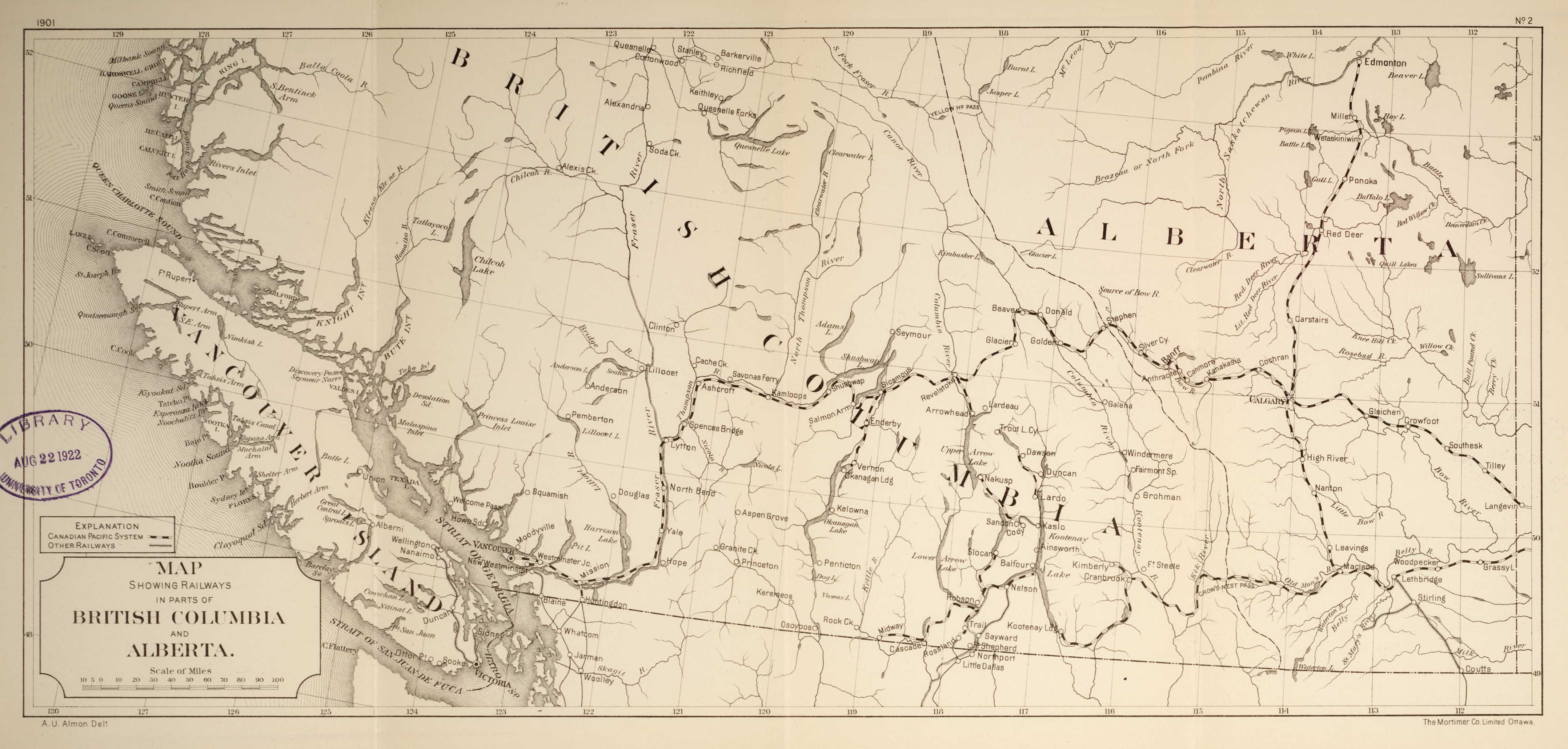
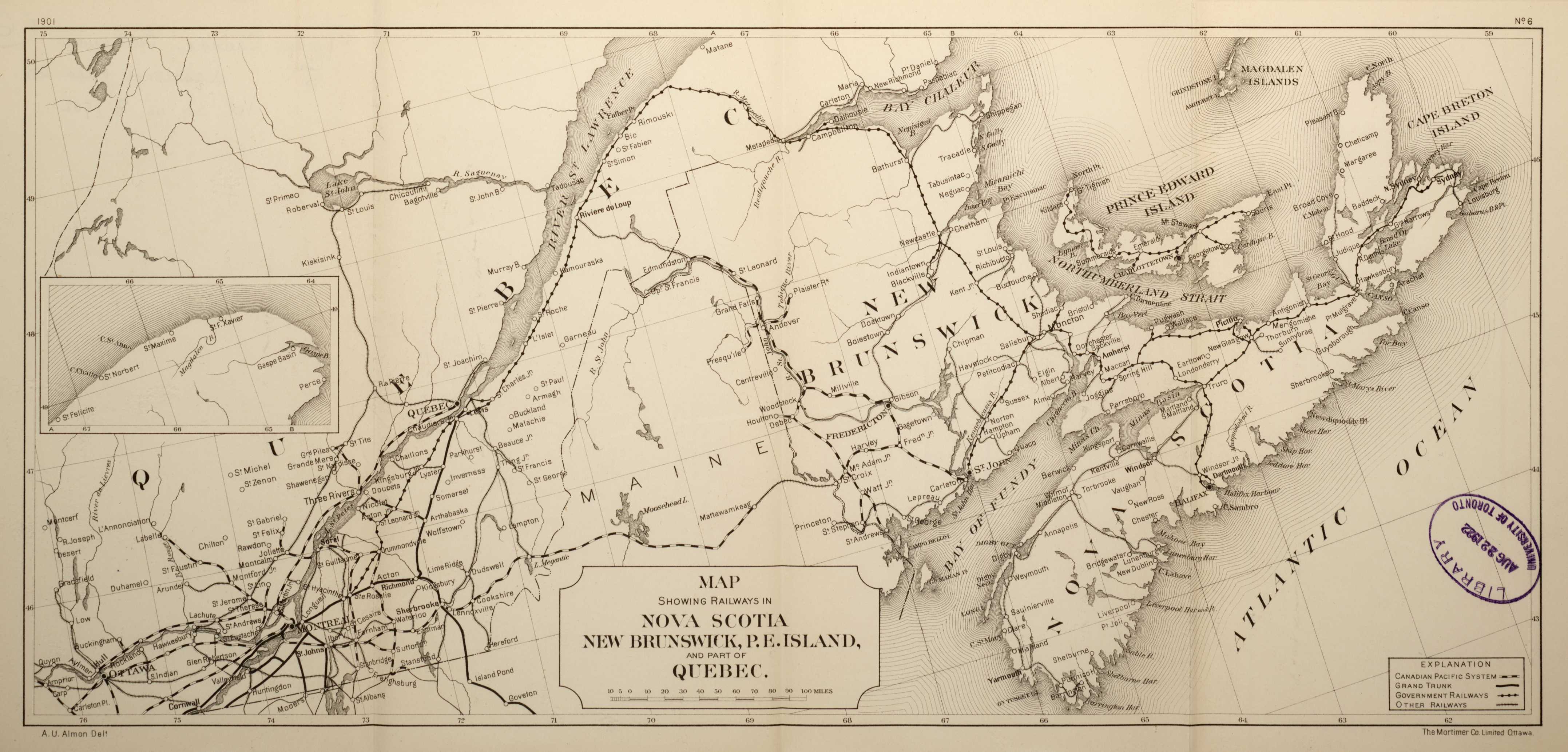
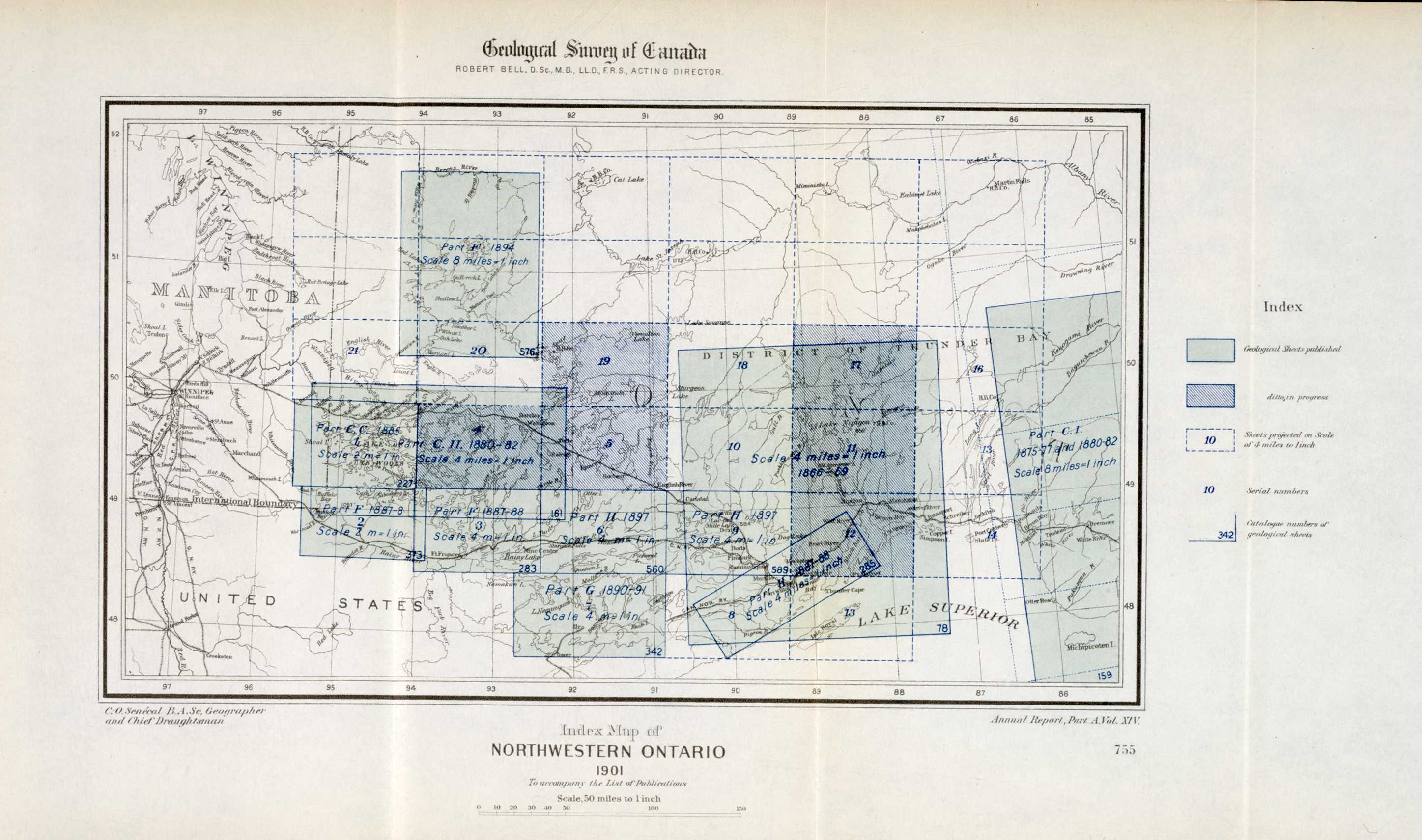
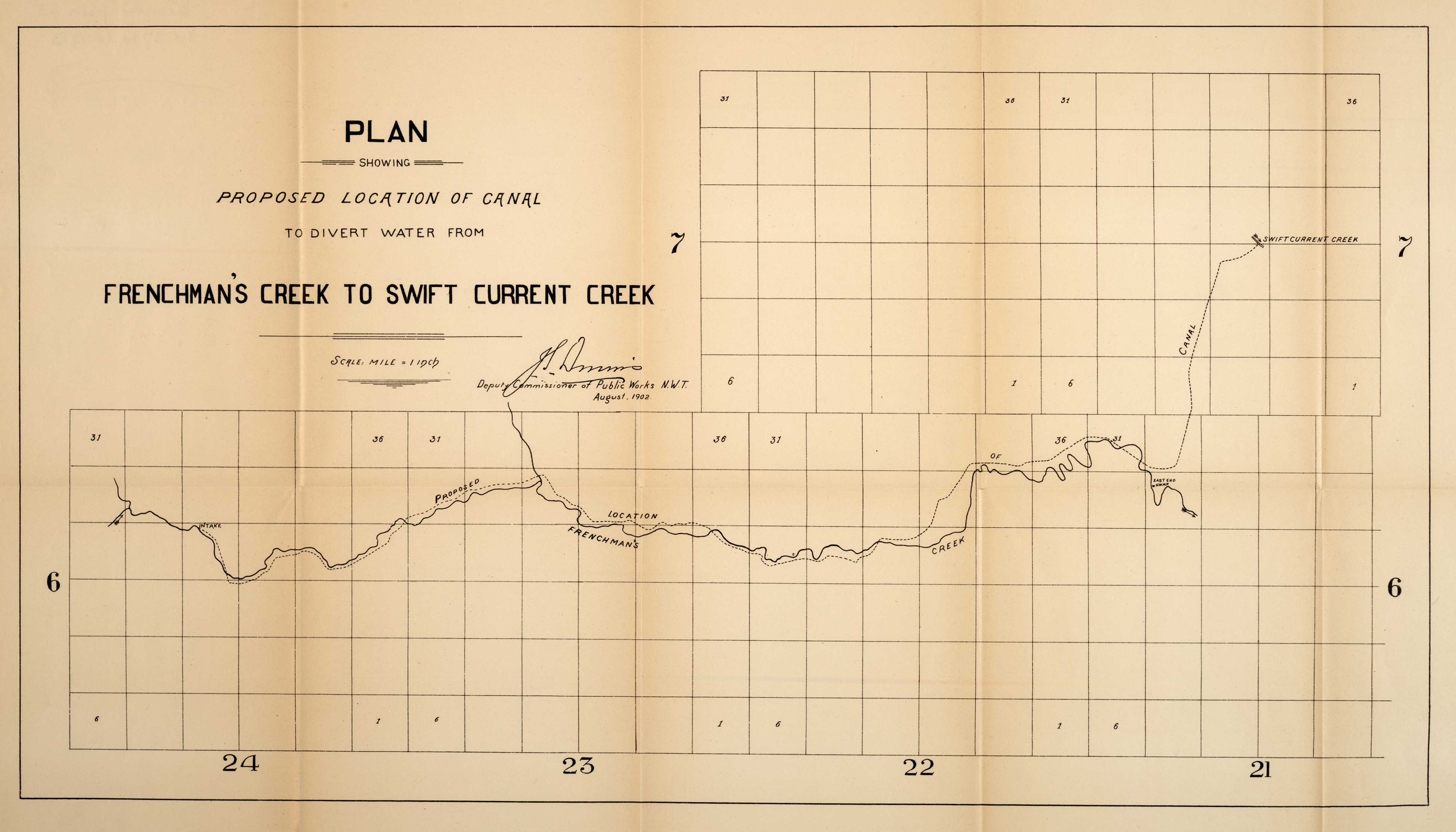
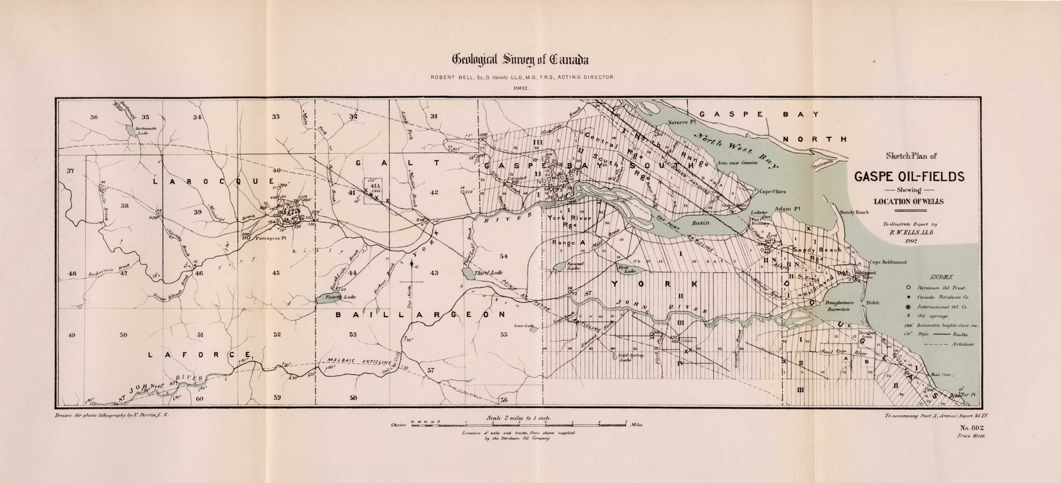
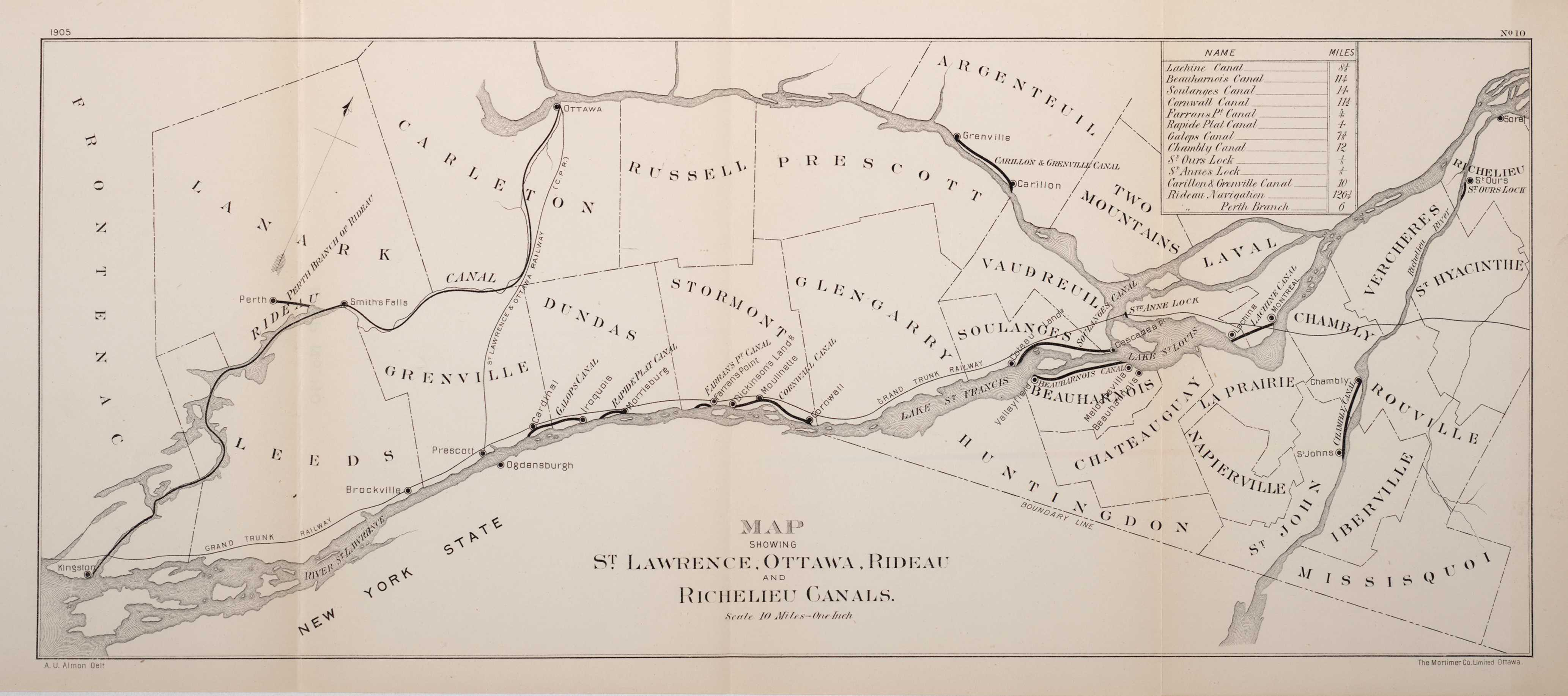
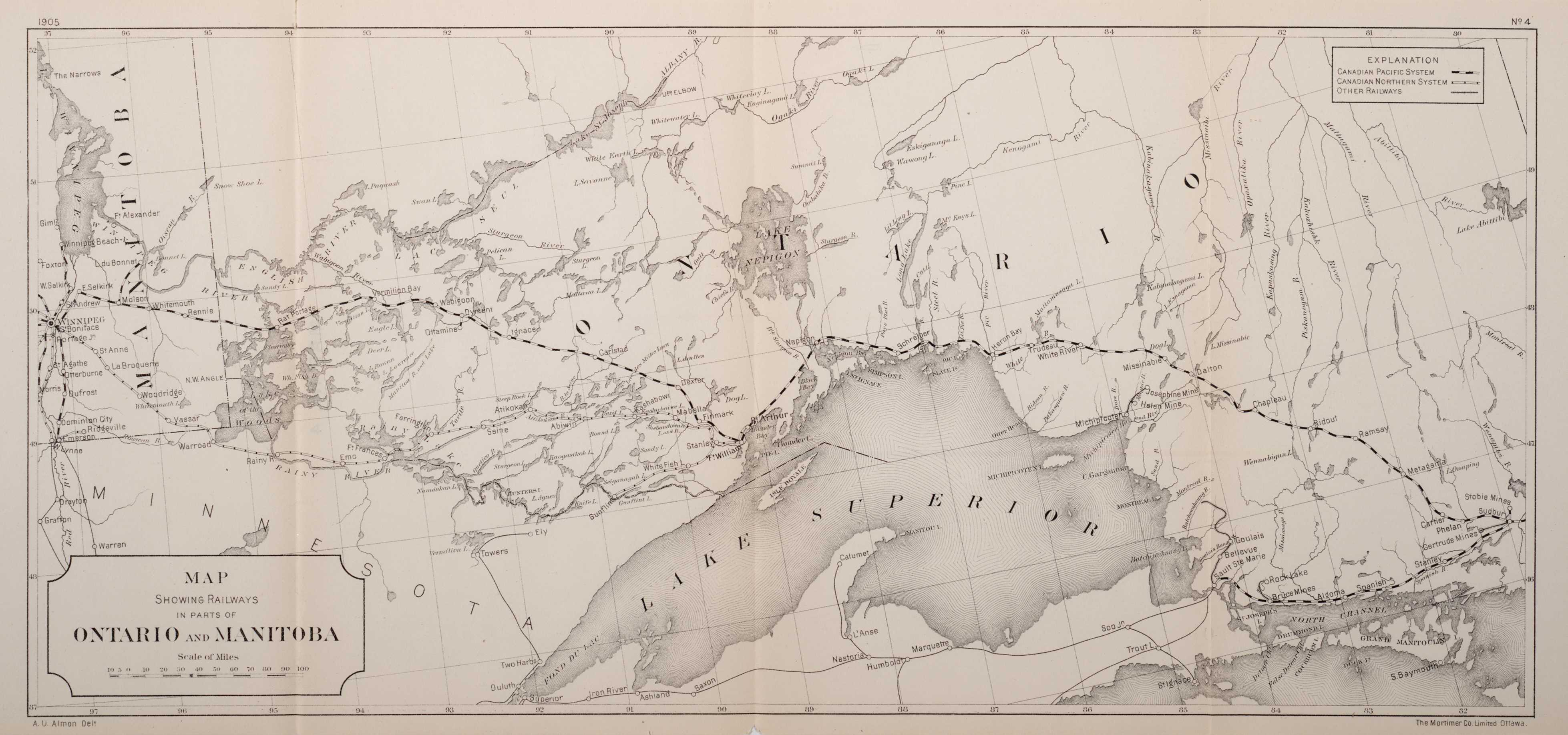
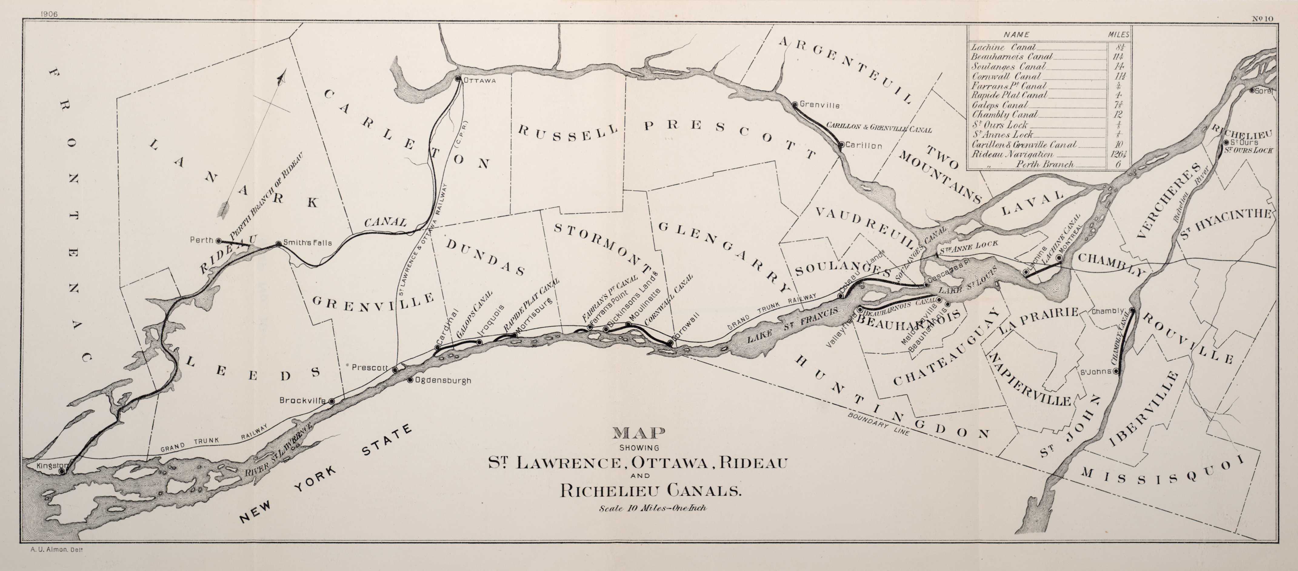
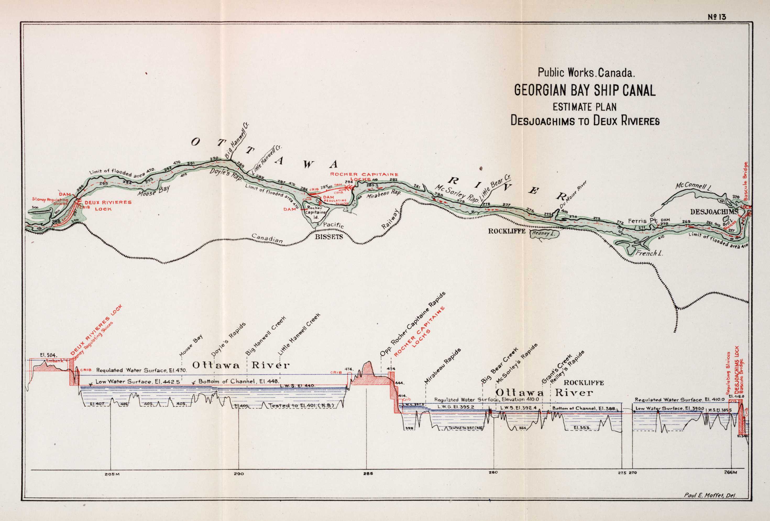
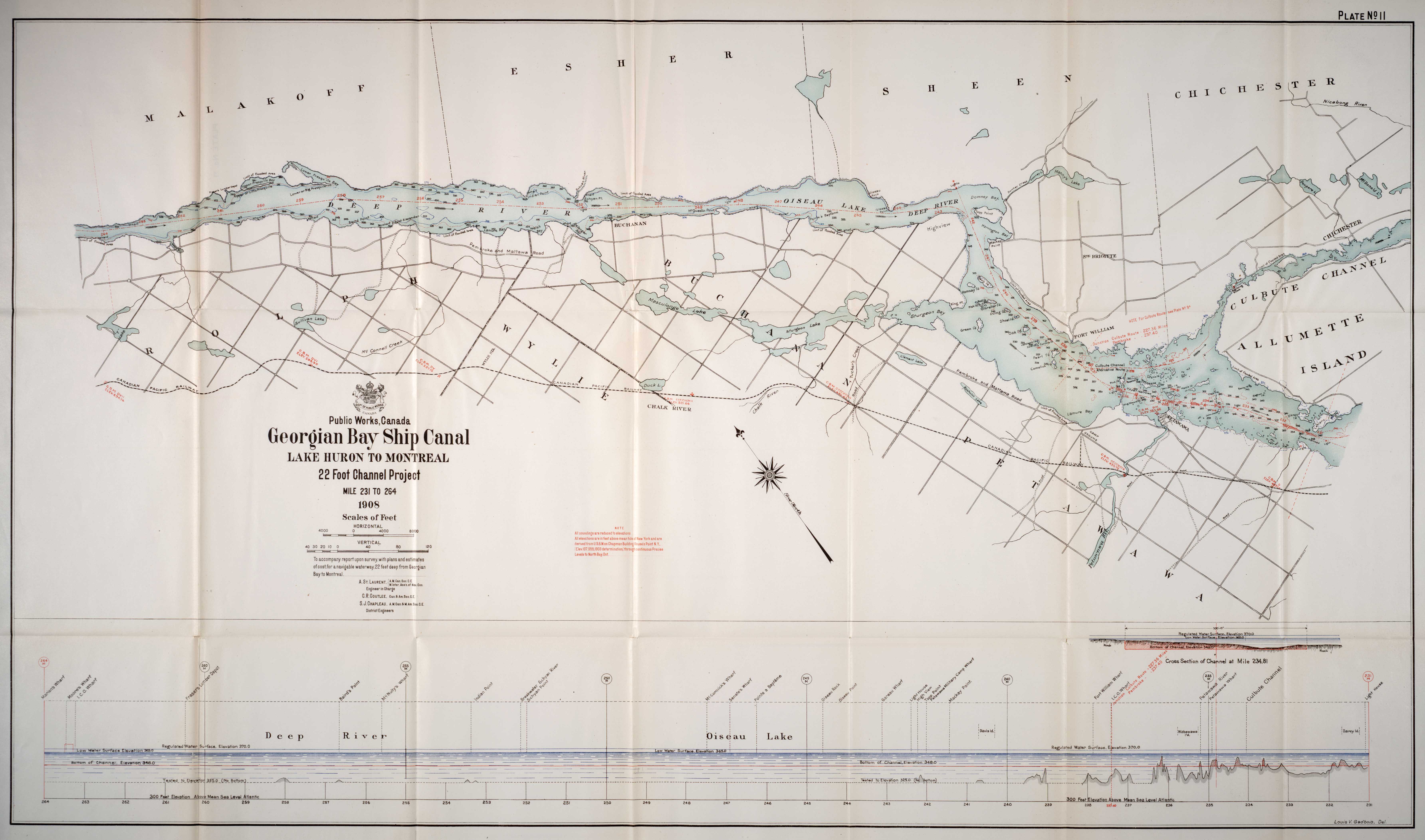
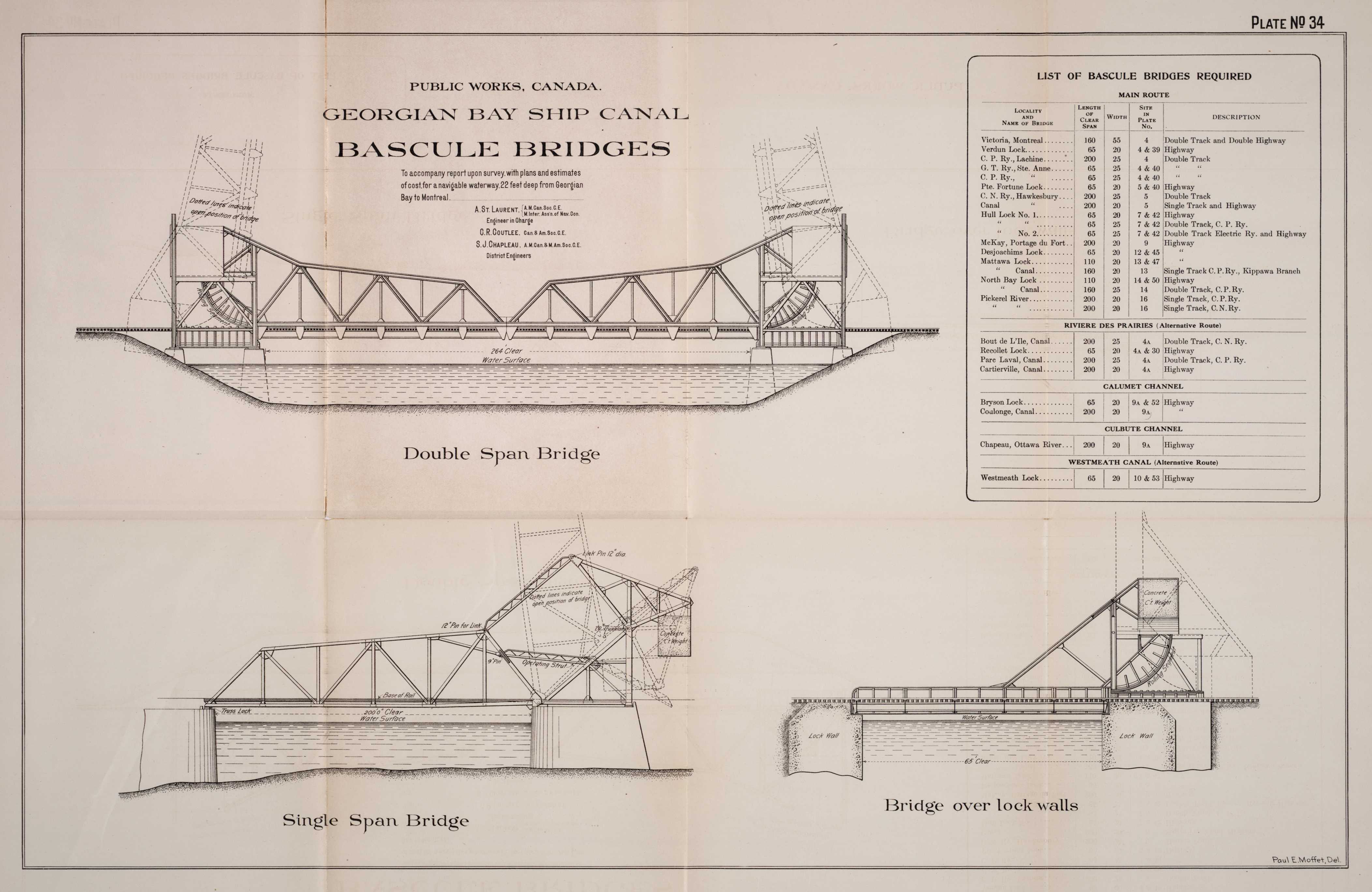
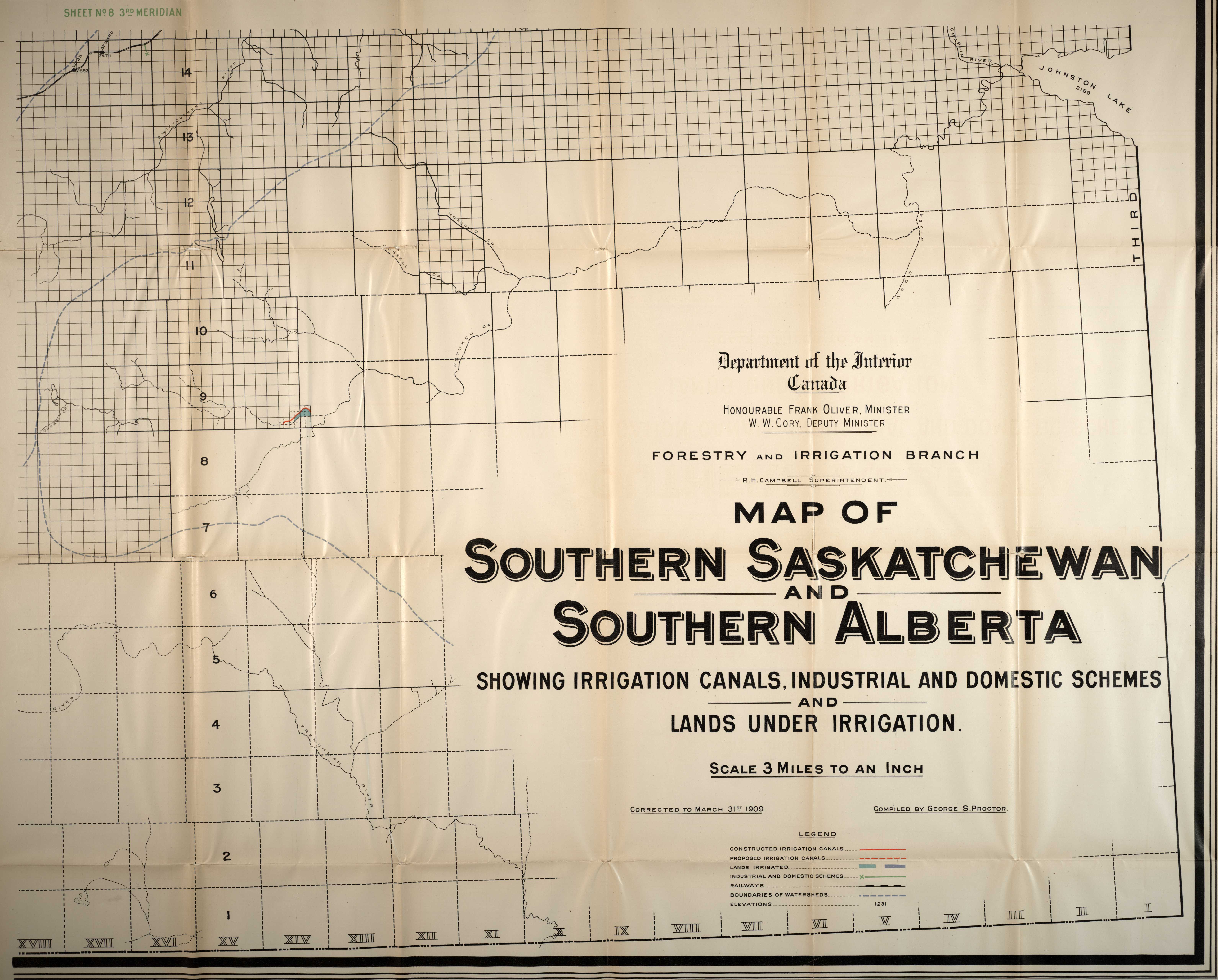
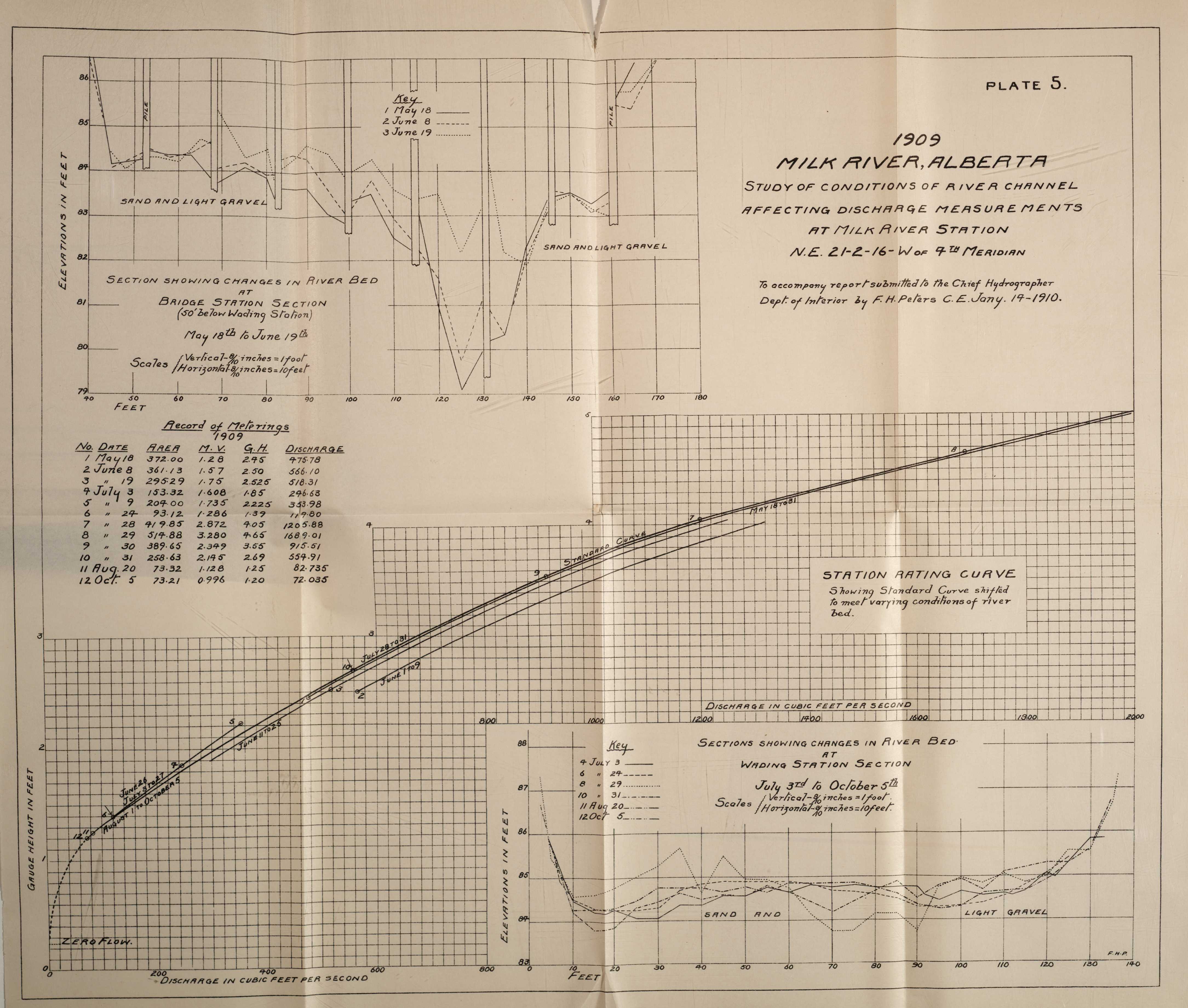
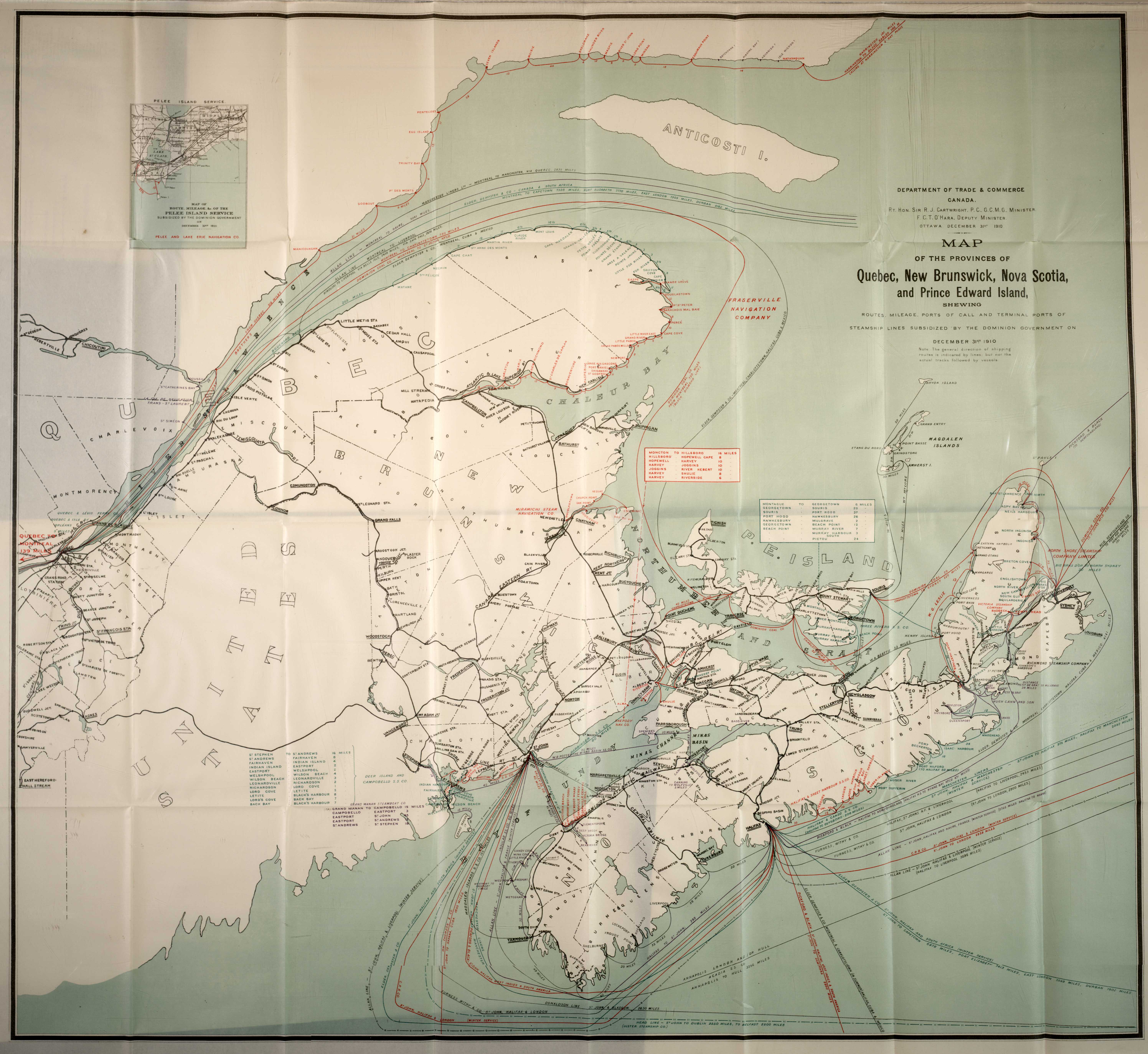
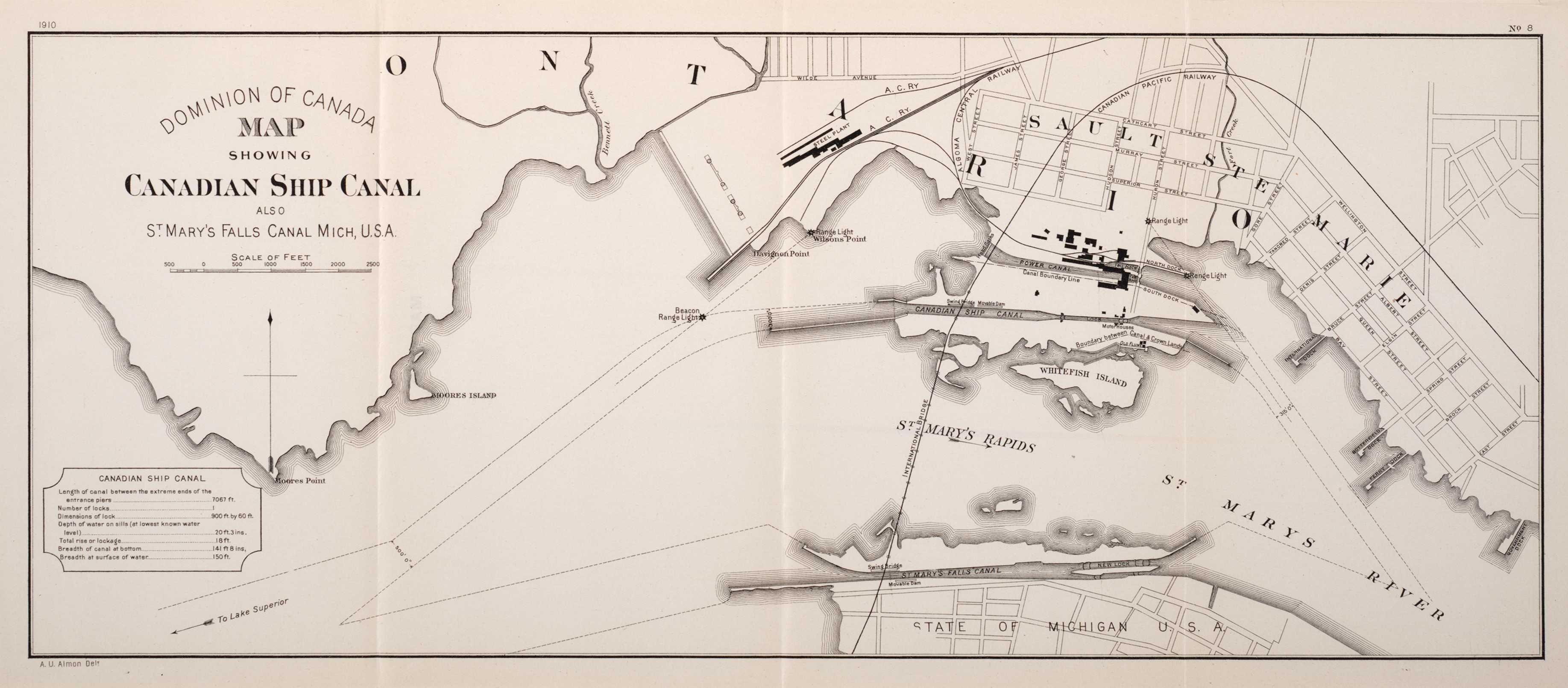
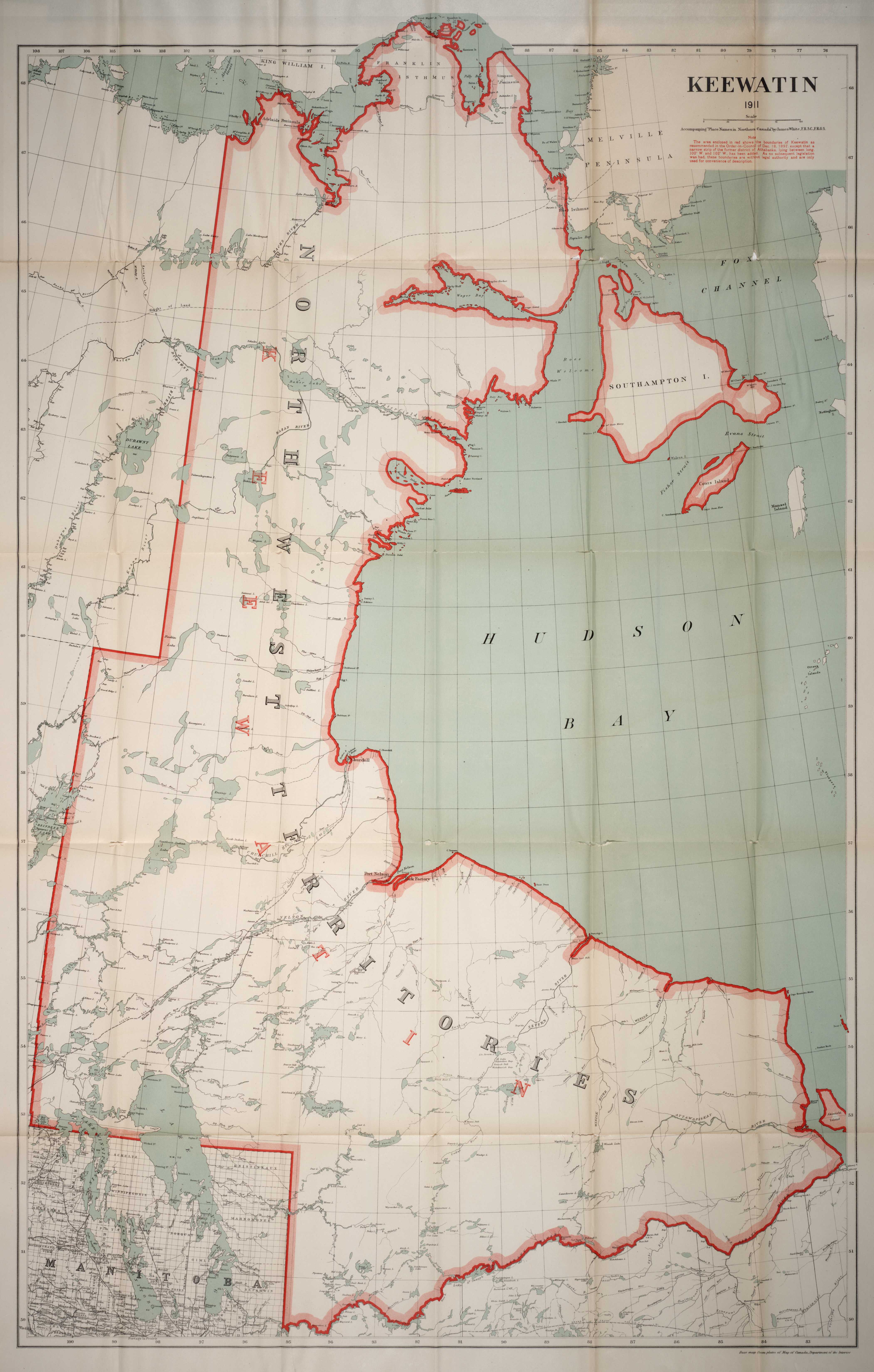
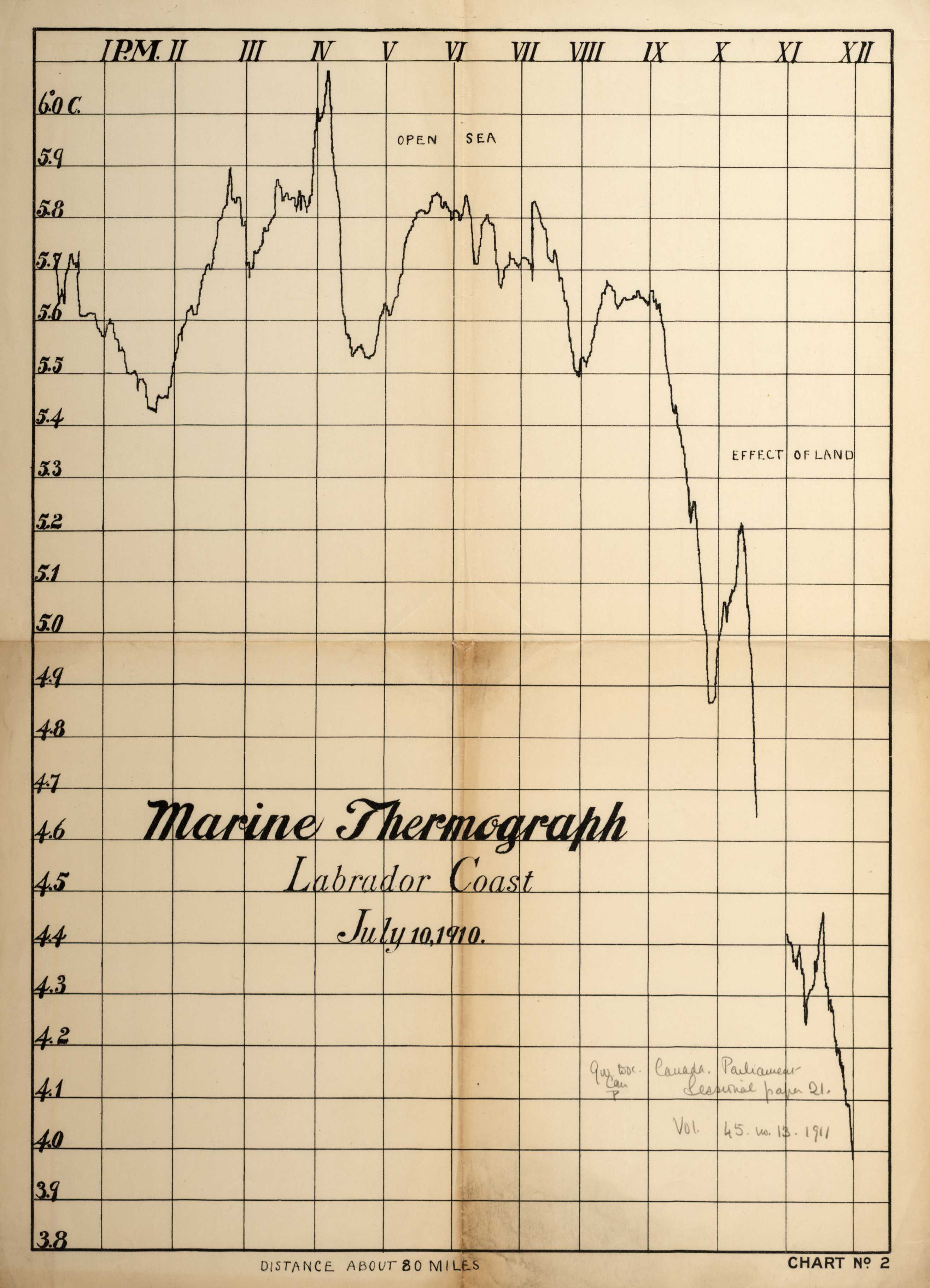
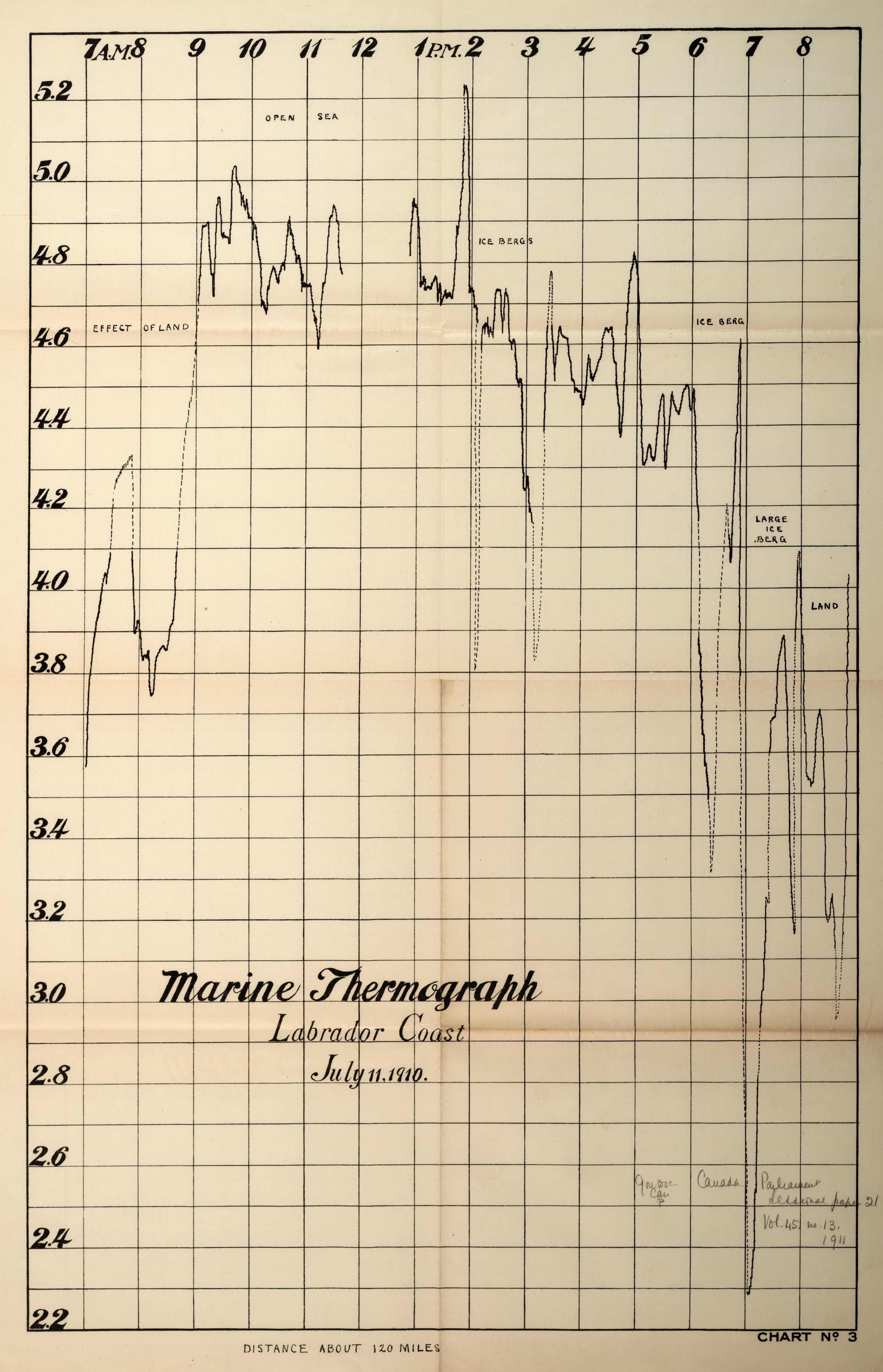
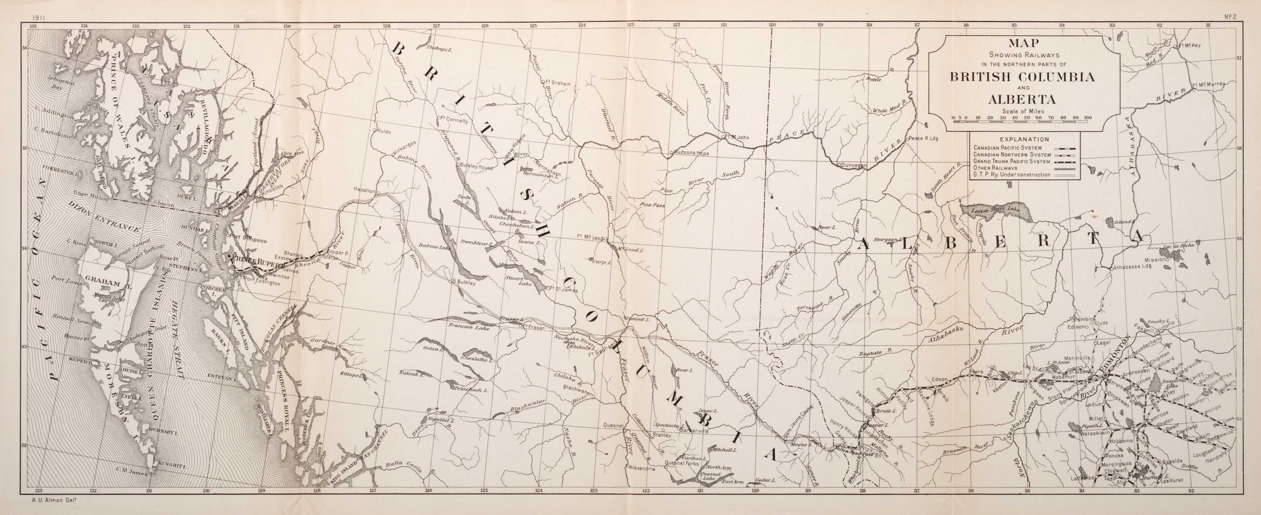
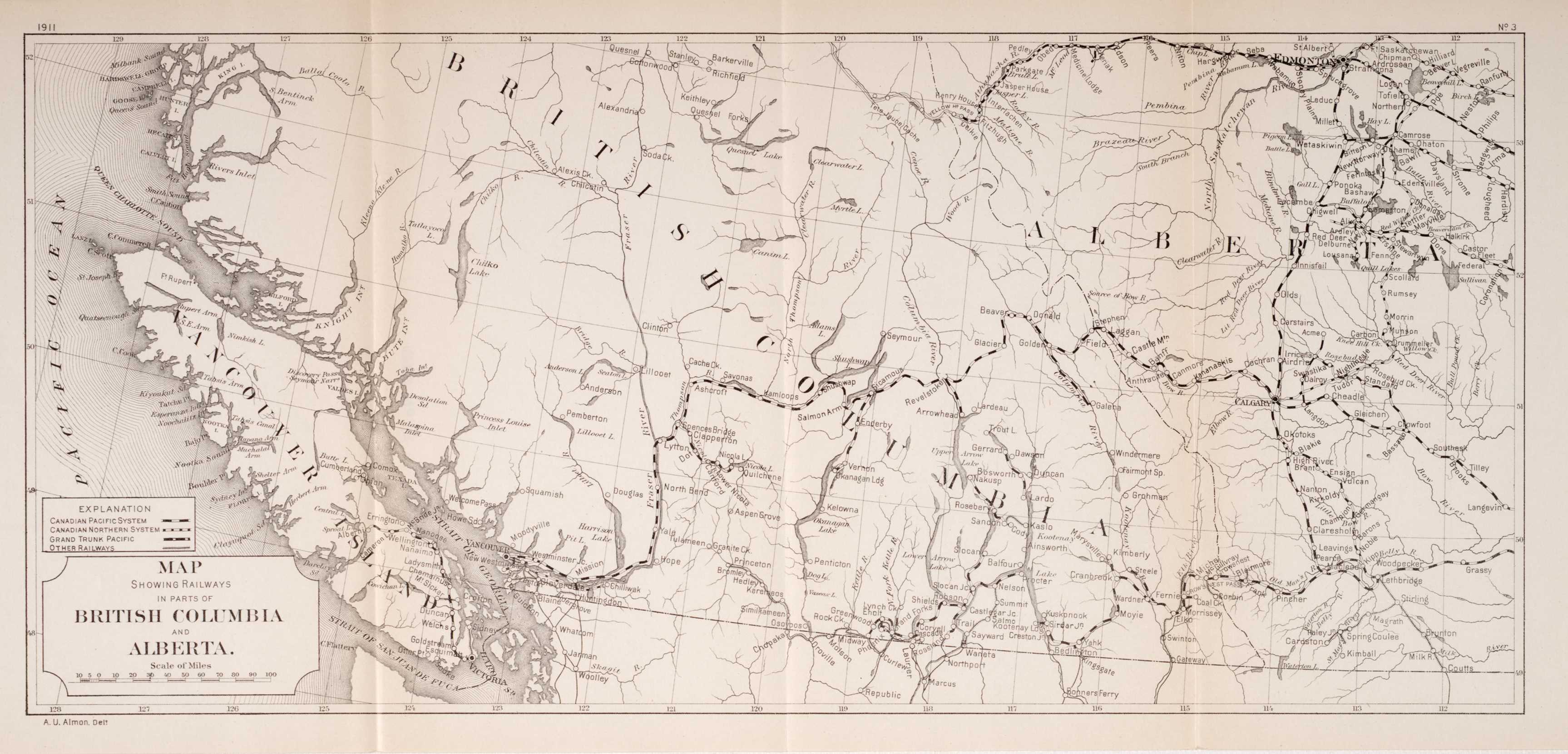
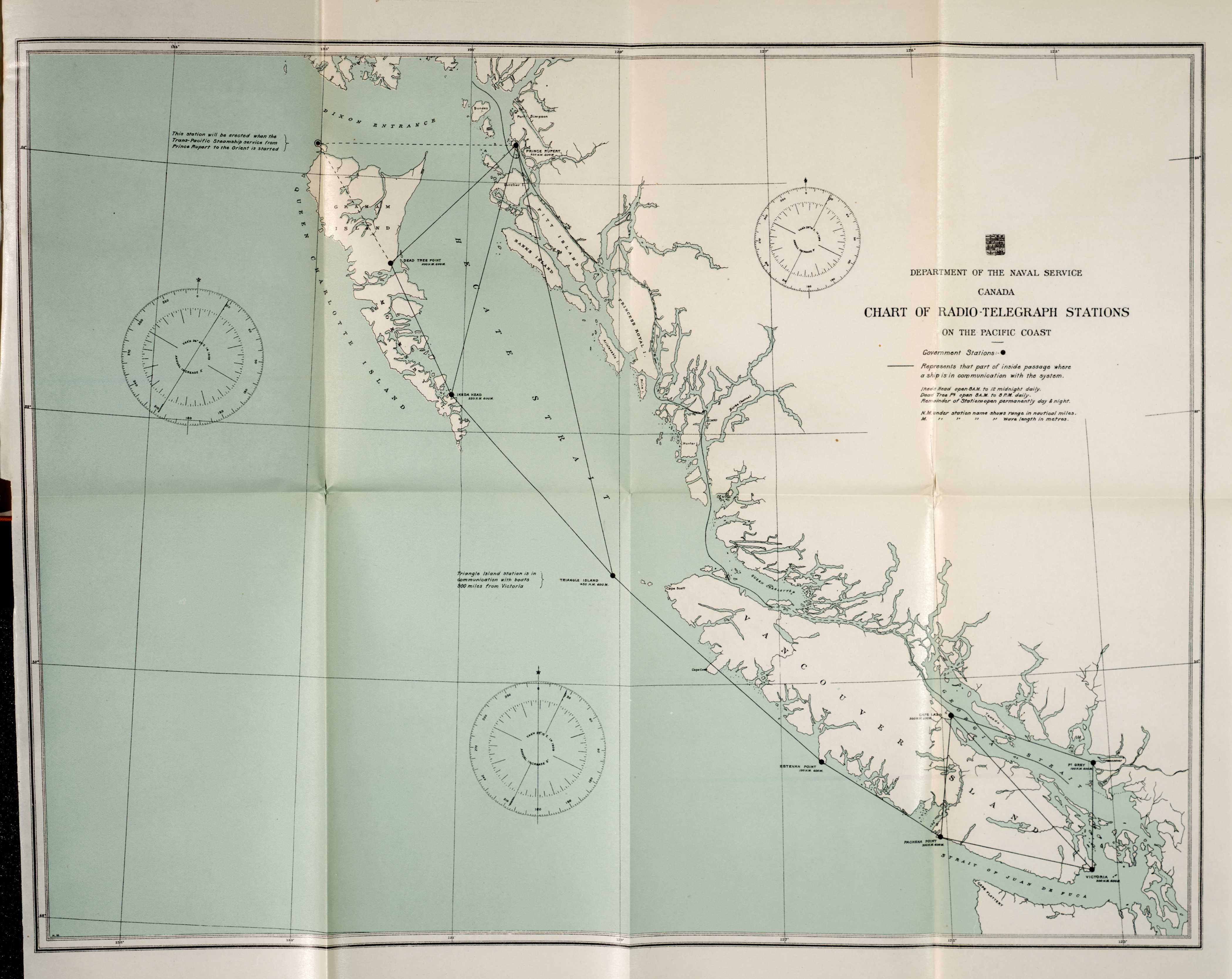
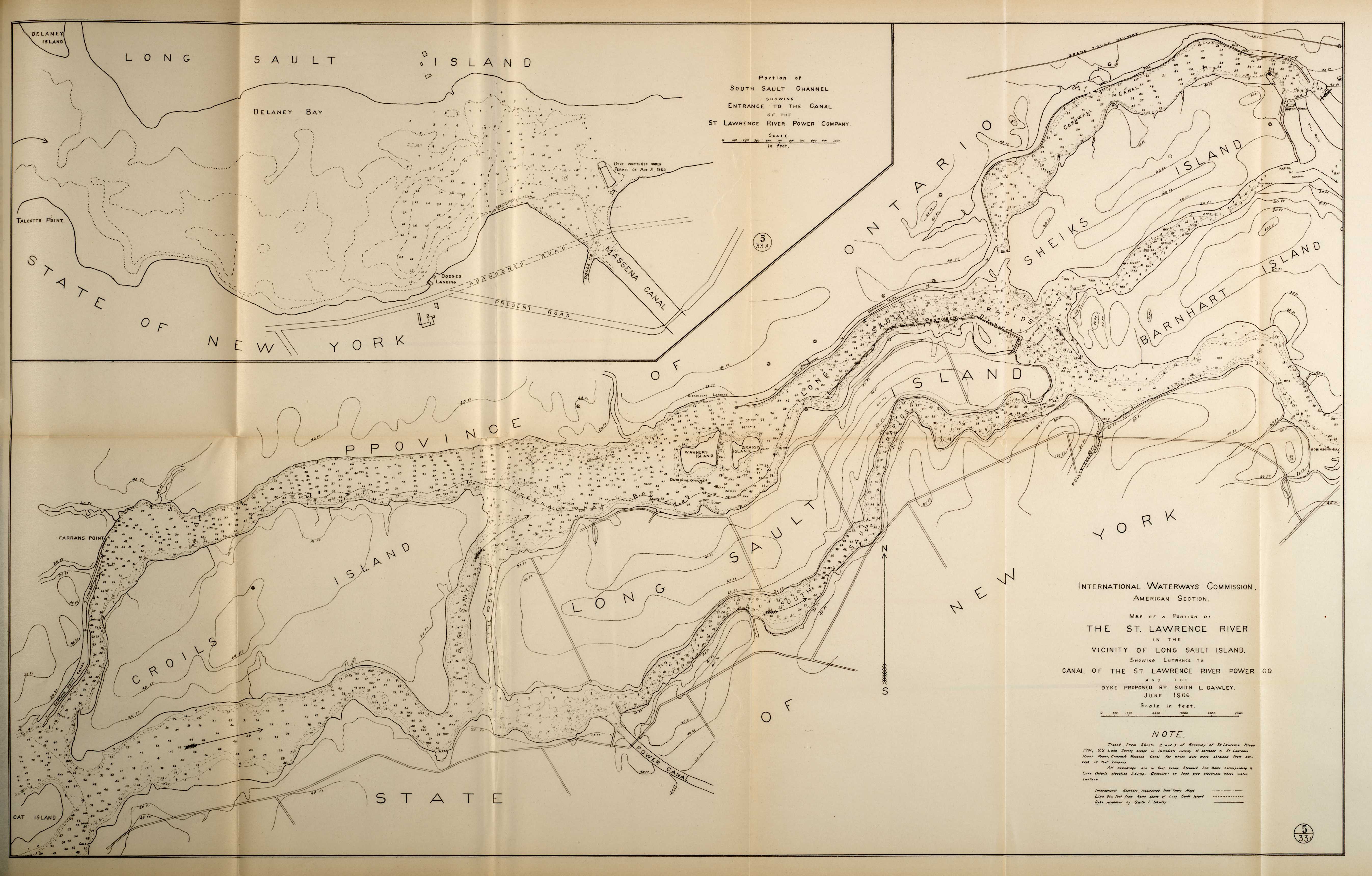
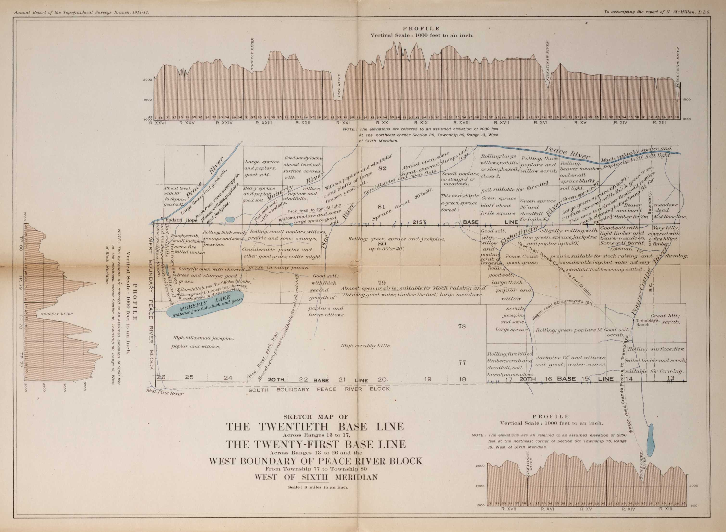
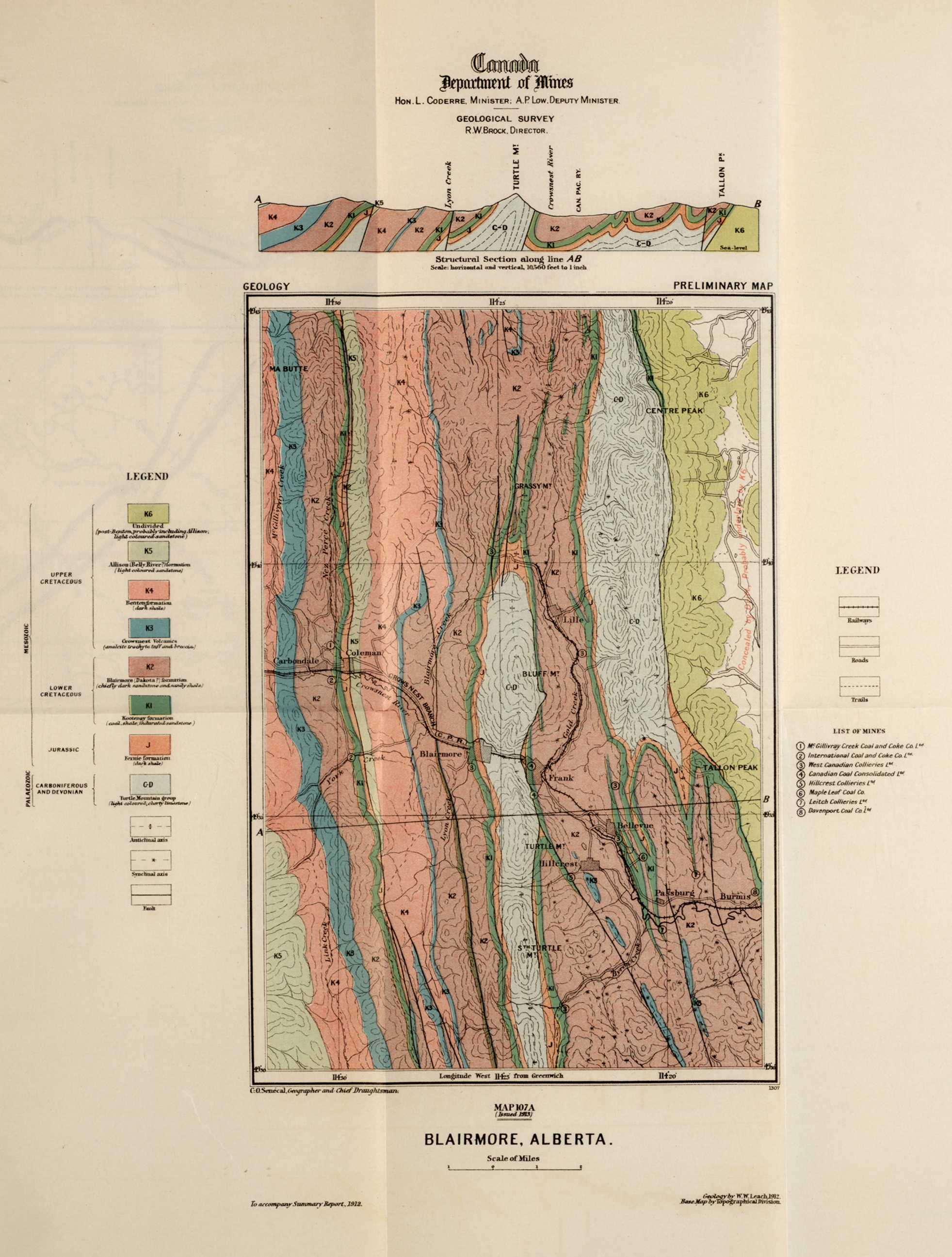
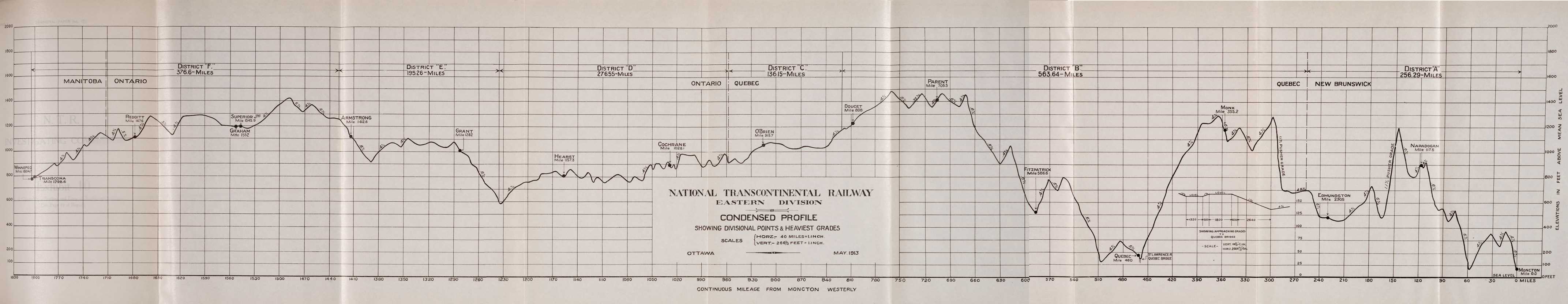
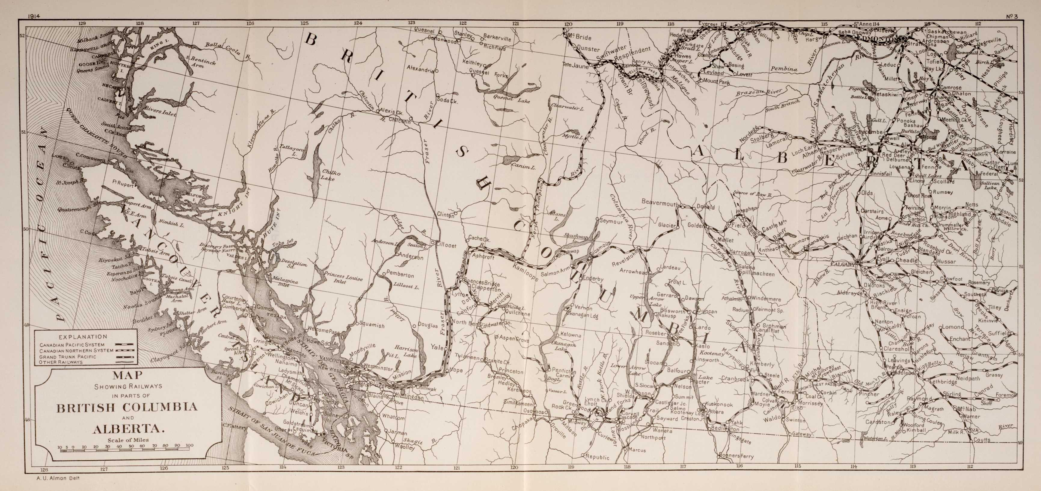
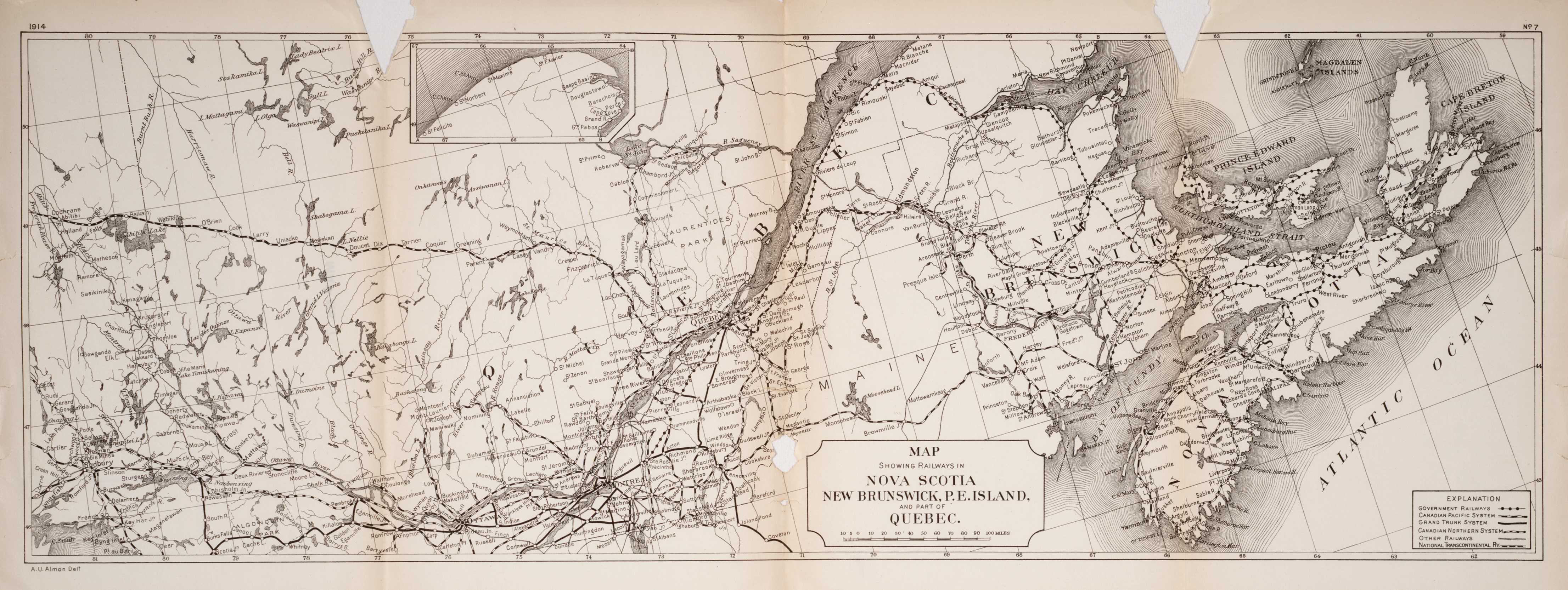
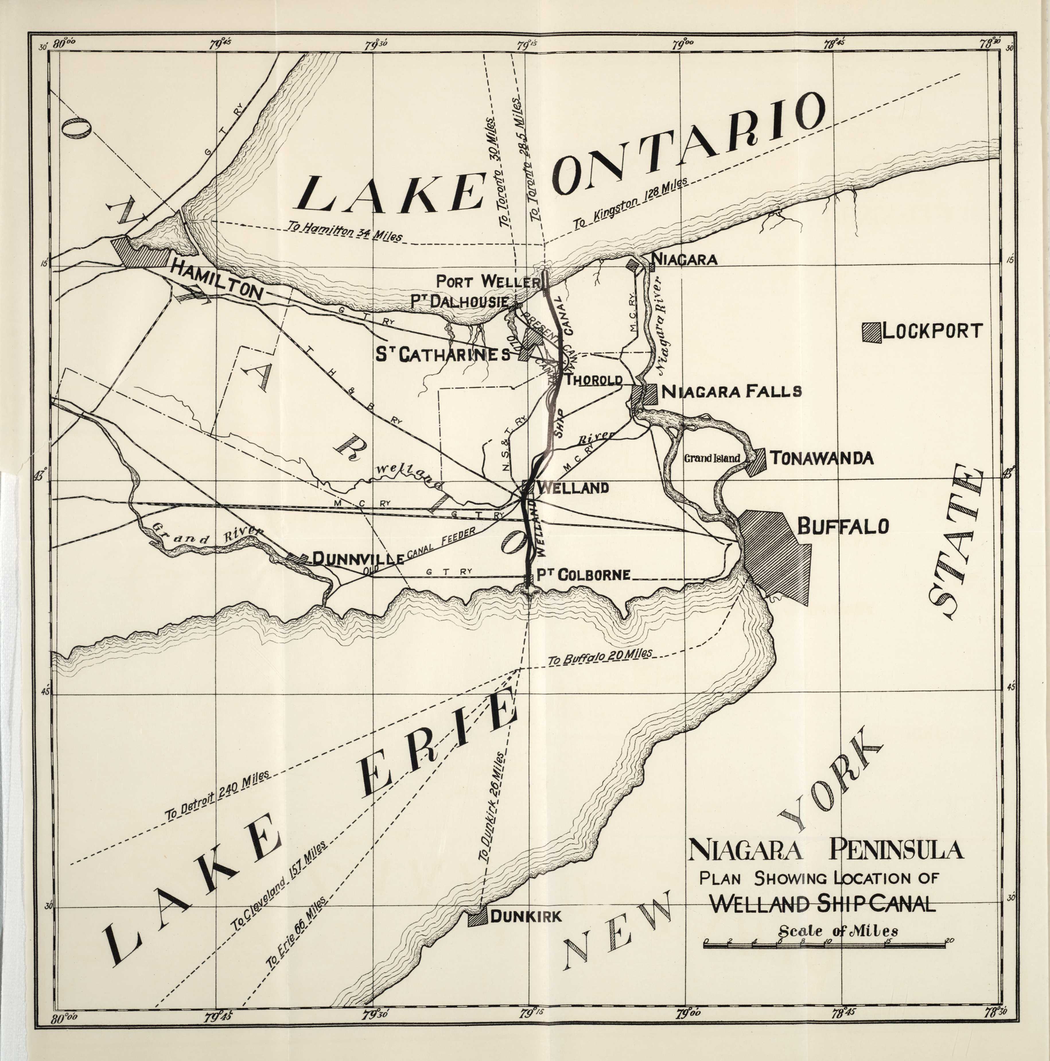
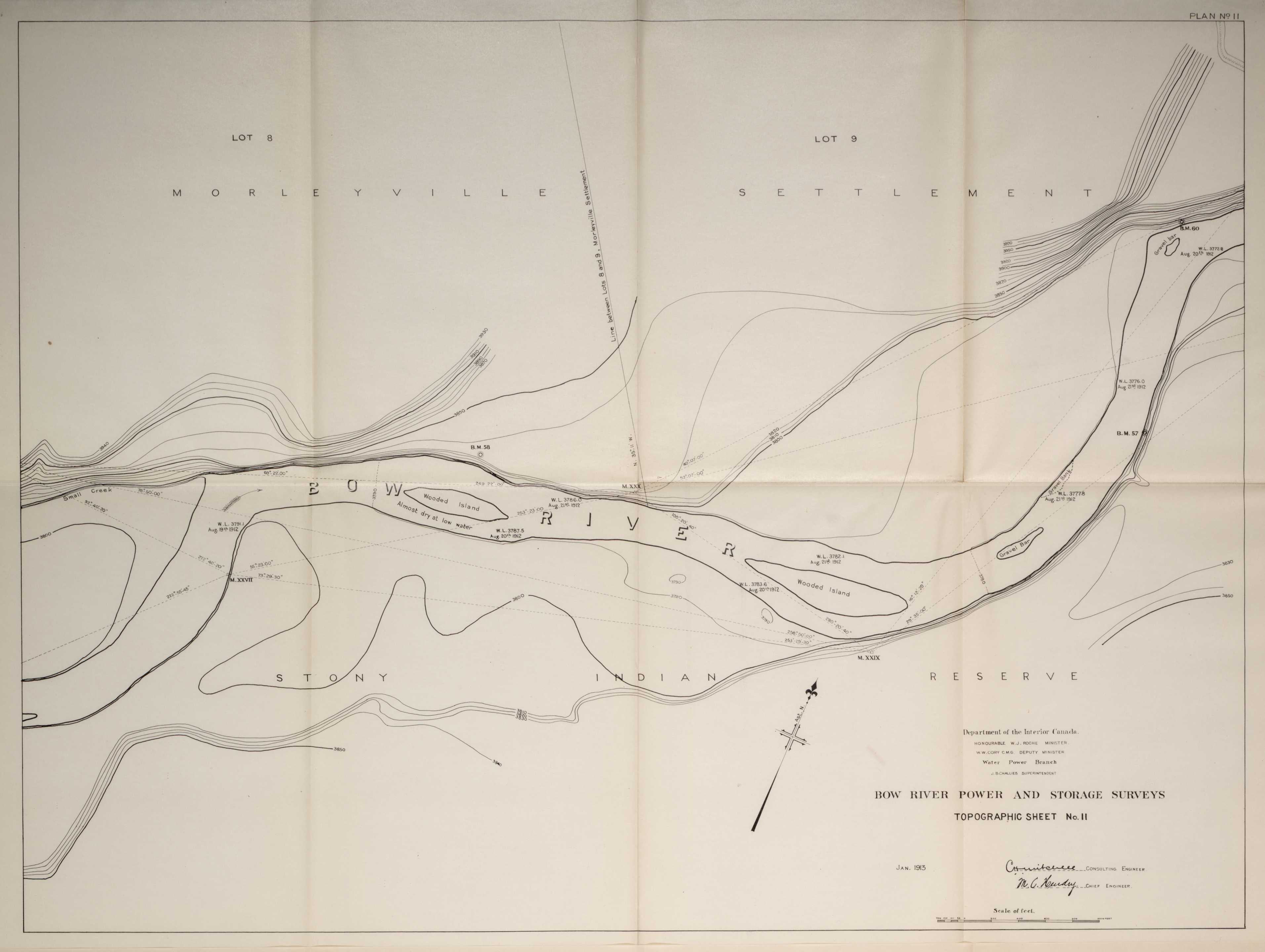
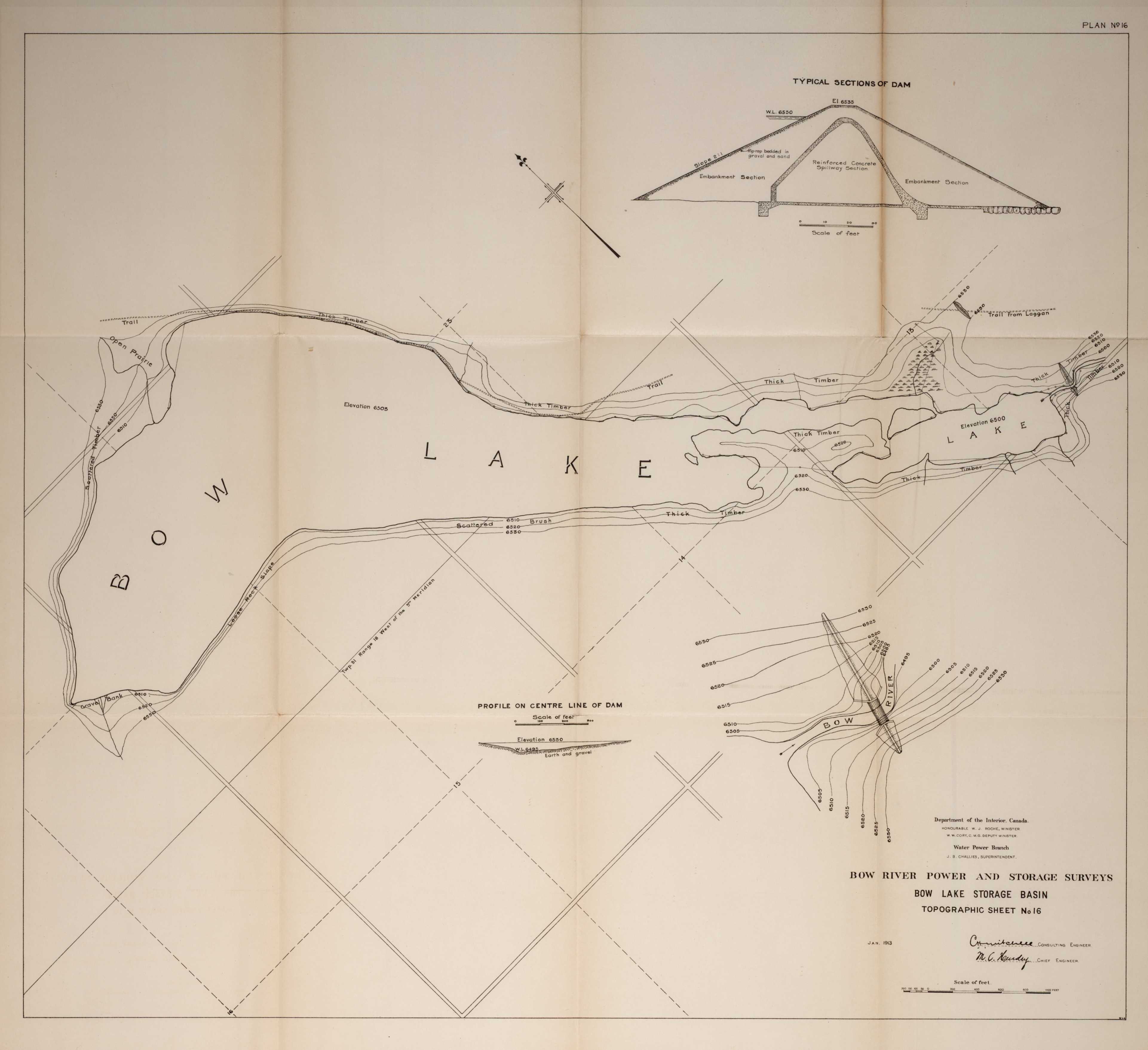
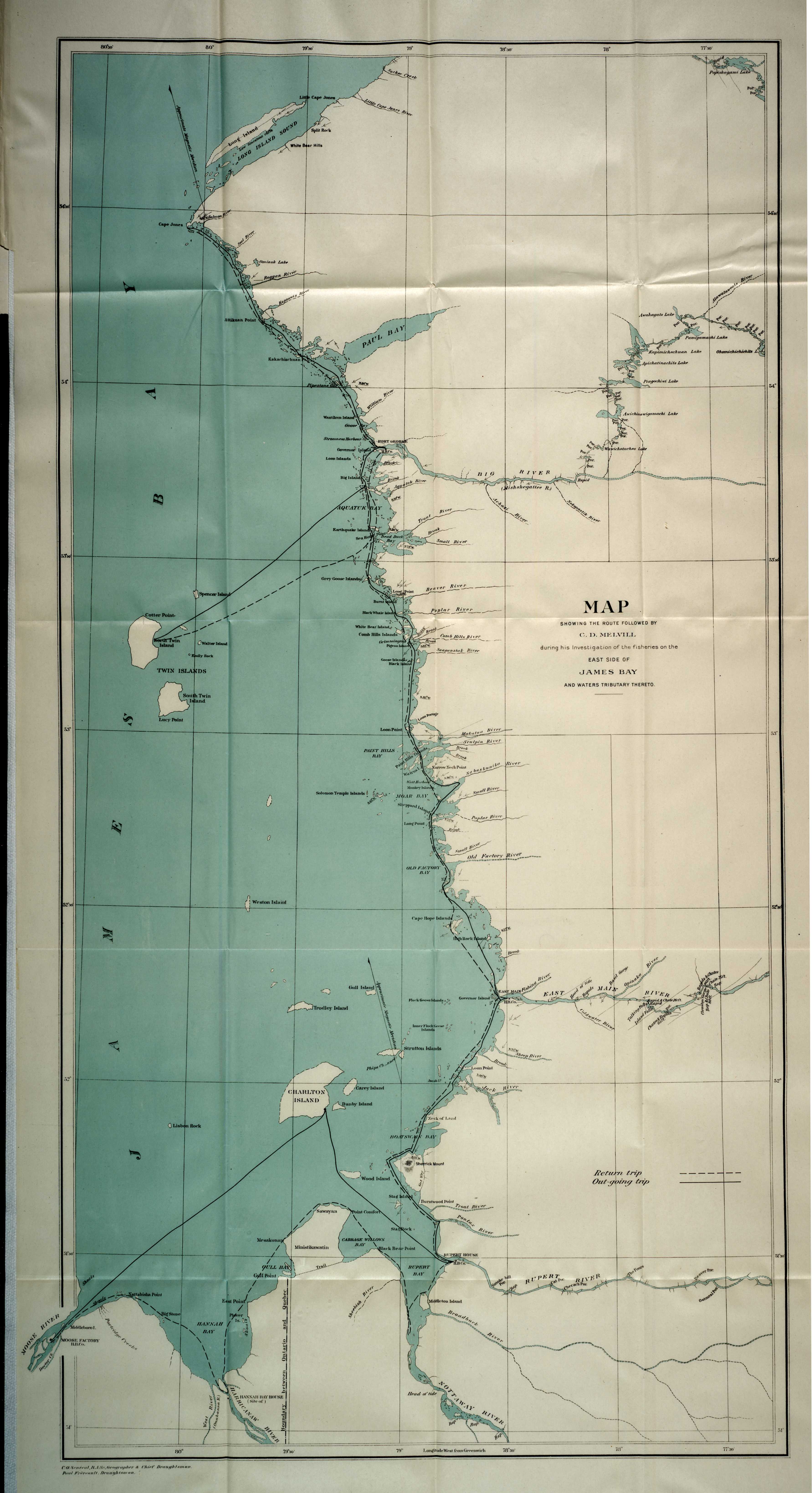
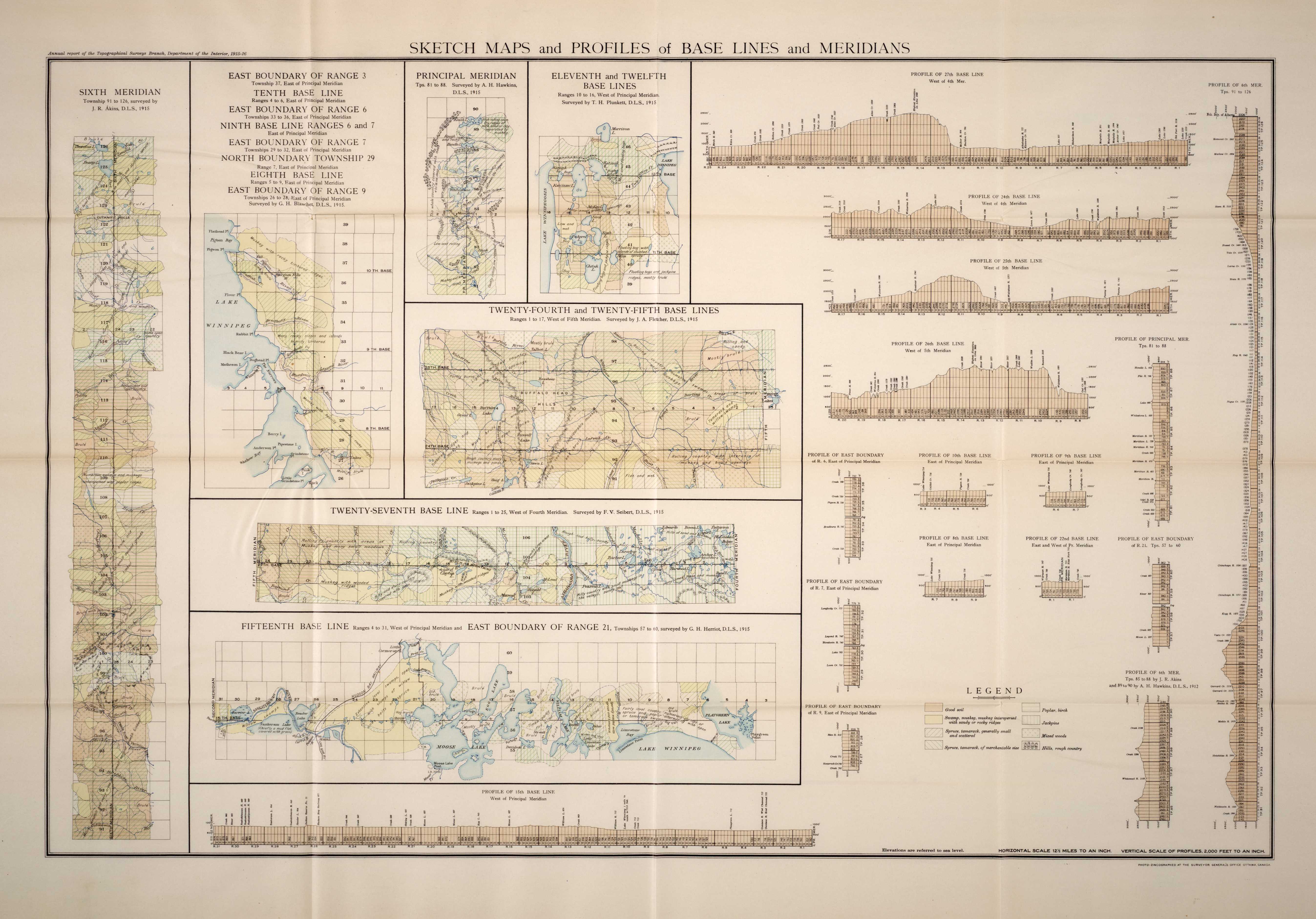
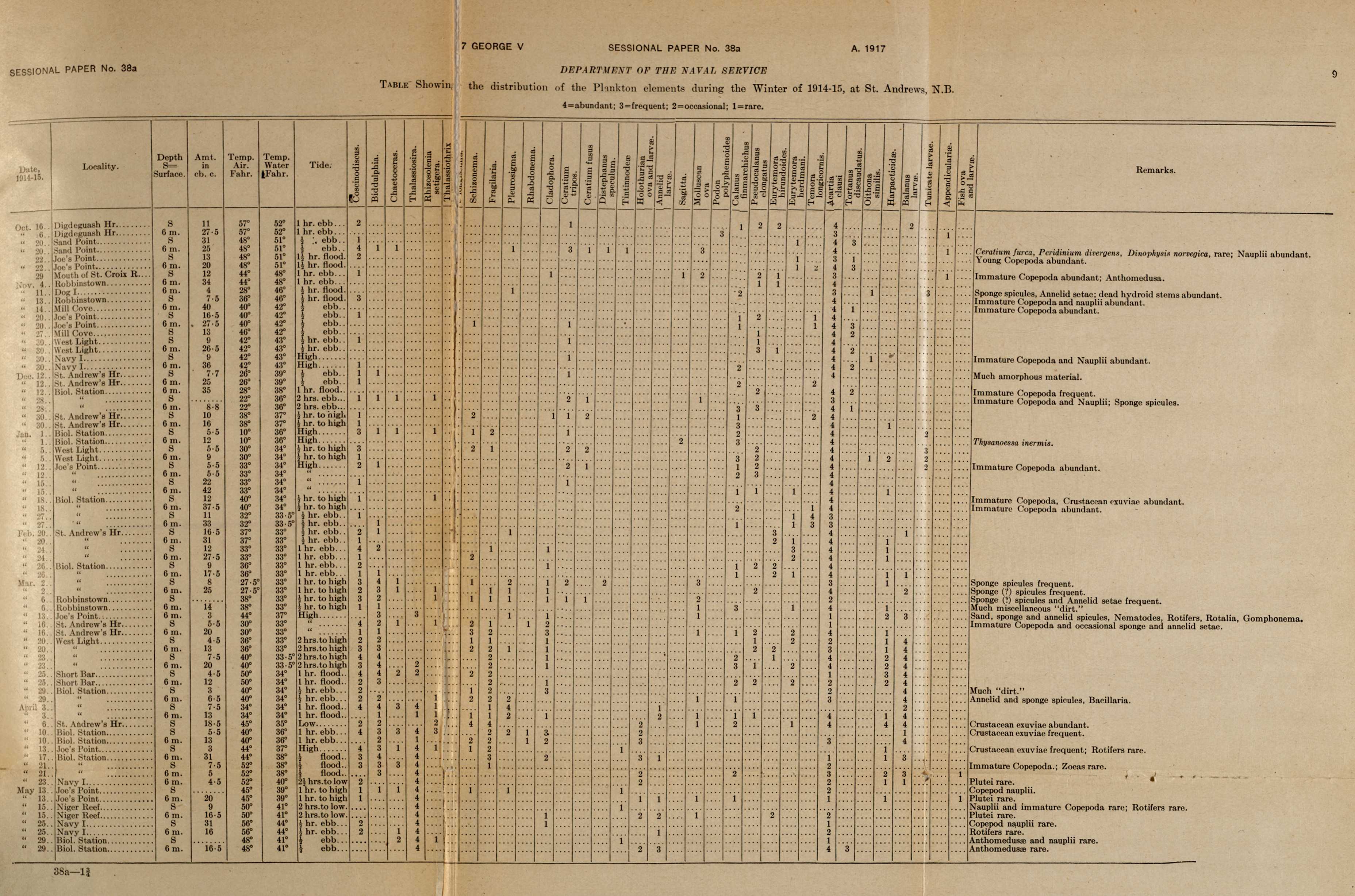