Map(s) of the Month: Bird’s-eye view maps

Bird’s‑eye view maps (also called panoramic maps, perspective maps, or aero views) are non‑photographic depictions of towns and cities drawn as if seen from an elevated oblique vantage point. They flourished in North America from the post‑Civil War decades through the early twentieth century as a distinct commercial and visual genre that combined detailed local surveying with lithographic reproduction.
Historical background and cultural role
Perspective city views have antecedents in European Renaissance city‑plans, but the North American bird’s‑eye tradition became distinctive in the nineteenth century: artists worked from ground surveys and hilltop vantage points to produce high‑oblique perspectives that emphasized street patterns, individual buildings, and industrial features. Several forces explain why the form flourished in the nineteenth century. First, technological change: improvements in lithography and chromolithography made it feasible to reproduce large, colored prints at a price that local boosters could afford. Second, urban and industrial growth created demand: rapidly expanding towns, railroads, ports, factories, and new civic institutions wanted visual statements of progress to attract investors, settlers, and customers. Third, a commercial market and itinerant artists developed. Mapmakers canvassed towns, displayed sketches, sold subscriptions, and then produced finished prints, so the production model itself encouraged proliferation. Finally, the prints served a rhetorical purpose: they promoted a particular image of modernity. Artists “aimed to depict communities in a positive light,” often emphasizing mills, rail lines, and public buildings while downplaying pollution, hazardous workplaces, or social problems (Shackel, 2024).

Bautzen, the main town in Upper Lusatia, as it stood on the day before the fire that broke out on April 22, 1709, (The parts of the town that were distroyed by the fire are emphasized by red evidently by parts of the copper plate being inked up with red ink with the help of a stencil and the others with black ink, thus making it possible to make two colour prints in one operation), Map & Data Library, University of Toronto
Although visually rich and often painstakingly accurate in plan and detail, bird’s‑eye views were promotional artifacts: they tended to minimize or omit social and environmental problems (pollution, hazardous workplaces, poverty) while foregrounding industry, transport, and civic architecture. Scholars have argued that these maps both record urban form and mask the harsher realities of industrial capitalism (Shackel, 2024). As Gerald Danzer points out, these maps "had to look accurate to be convincing, but not so honest as to reveal the problems and imperfections of their subjects" (Danzer, 1990). Chambers of commerce, real‑estate interests, local businesses, and civic leaders commissioned these views as booster material: the prints advertised a town’s commercial promise, civic institutions, and built amenities to prospective investors and settlers. Publishers and itinerant artists canvassed towns, displayed preliminary sketches, and sold subscriptions before producing the final lithograph. The prints functioned as both decorative wall art and practical sales tools.

T. M. Fowler’s Miners’ Mills and Mill Creek ,1892, Library of Congress
For many towns the bird’s‑eye view is the most detailed nineteenth‑century visual record: street layouts, factory complexes, rail lines, docks, and individual public buildings are often labeled or rendered with recognizable detail, making these maps invaluable for reconstructing historical urban form. These views captured the rapid urban and industrial expansion of the Gilded Age - smokestacks, railroads, harbors, and dense built fabric - thus shaping contemporary and later perceptions of progress and modernity. At the same time, the genre’s selective emphasis reveals the ideological work of representation in an era of minimal regulation and intense capital accumulation. T. M. Fowler’s Miners’ Mills and Mill Creek (1892) shows how a panoramic map can record industrial layout (breakers, rail lines, culm banks) while presenting a tidy, ordered townscape that masks the environmental and human costs of mining.
Cartographic qualities and techniques
Fieldwork and composition
Artists typically walked every street and sketched buildings on site, then assembled those sketches into a perspective grid in the studio. The resulting composition simulates a viewpoint several thousand feet above the city at an oblique angle; street patterns remain legible while buildings are drawn in two‑point perspective so facades and side elevations are visible. This labor‑intensive method produced maps that were not strictly to scale but were highly informative about relative positions and building forms.

Constantinople. استانبولل منظره عموميه سى [General View of Istanbul], created by John Hoffmann in 1896, David Rumsey Map Collection.
Two‑point perspective and selective emphasis
Mapmakers used perspective grids and selective vanishing points so that foreground and background buildings could be rendered with comparable visual weight; wealthier districts and major commercial buildings were drawn with greater resolution, while poorer neighborhoods received simpler treatment. This selective detailing both increased market appeal and encoded social hierarchies into the image.

Bird's eye view of Chatham, Ontario. [N.p., between 1870 and 1880, 1870], Library of Congress
Lithography and reproduction.
After the manuscript composition, the image was transferred to lithographic plates (zinc or aluminum) and printed in runs typically between a few dozen and a few hundred copies. Chromolithography allowed colored editions and decorative insets (building vignettes, advertising panels), which enhanced the print’s appeal as a framed object.
Annotation and indexing
Many panoramic prints included numbered keys or marginal vignettes identifying important buildings (courthouses, schools, factories). These keys convert the image into a quasi‑map: viewers can locate named sites within the pictorial field, which increases the print’s documentary utility.
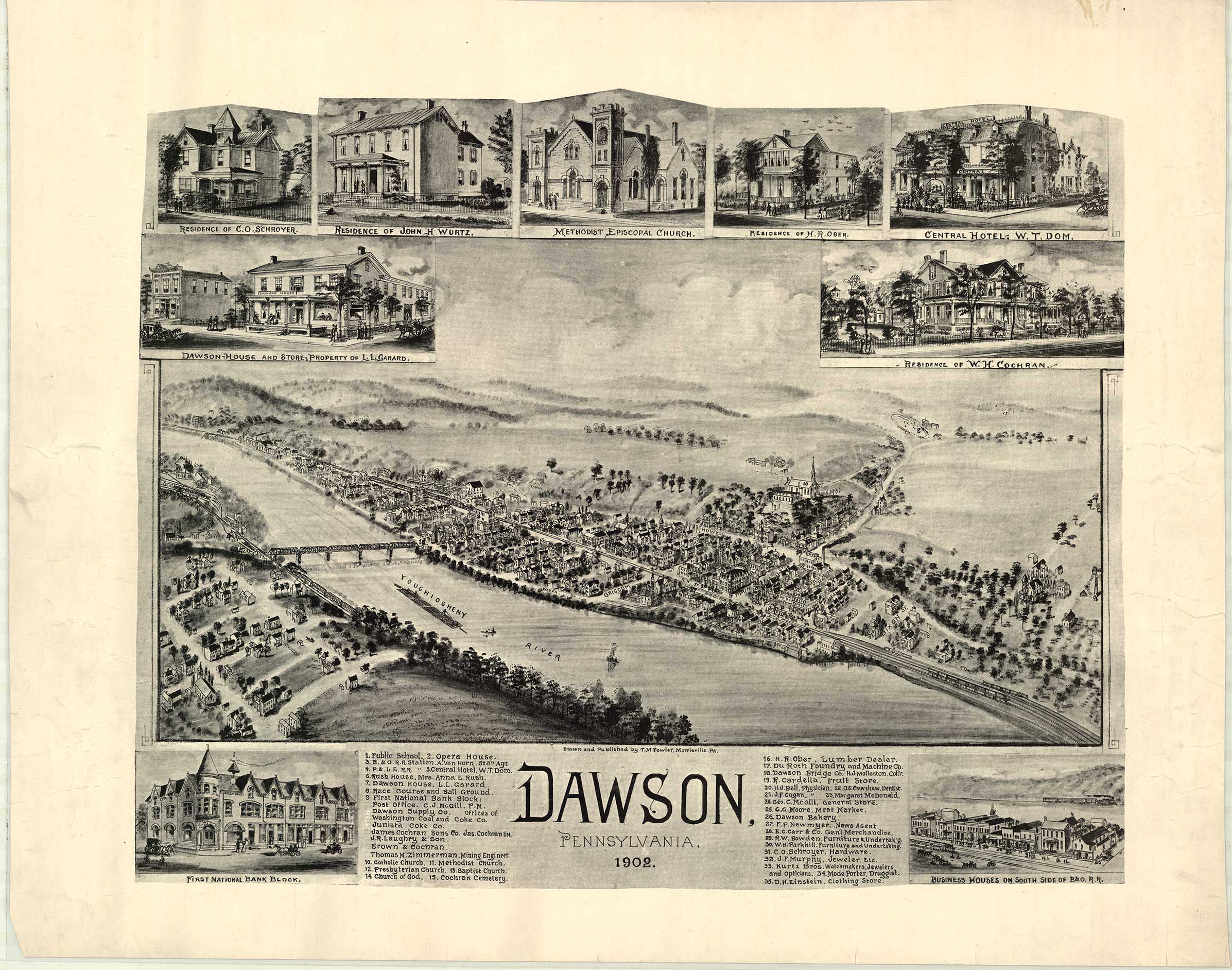
Dawson, Fayette County, Pennsylvania, 1902. Drawn and Published by T. M. Fowler, Morrisville, Pennsylvania (Shows: schools, opera house, hotels, race course and ball ground, railroad, churches. Inset: bank, private residences, store, business houses), Pennsylvania State Archives
P. A. Gross’s 1876 bird’s‑eye view of Toronto
Peter Alfred (P. A.) Gross’s 1876 Bird’s‑Eye View of Toronto is a landmark example of painstaking field survey and monumental composition. Gross reportedly walked every street and sketched some 14,000 buildings; the finished lithograph measured roughly five feet by three feet and was lithographed by Copp, Clark & Co. The accompanying guidebook (Illustrated Toronto, 1877) provided a keyed index to major buildings and institutions.
Gross’s view adopts a high oblique vantage (the map is described as “as if seen from a point 5,000 feet above the southeastern part of the island”), rendering the harbor, rail lines, institutional complexes, and the varied densities of urban fabric with exceptional granularity. The map shows features later lost (early Union Station, Grand Opera House) and buried waterways (Garrison Creek), making it an indispensable resource for Toronto urban history.

Peter Alfred Gross's Birds-Eye View of Toronto, 1876, Map & Data Library, University of Toronto
The Toronto view functioned as civic self‑representation: it celebrated industrial and commercial growth while offering residents a visual inventory of the city’s assets. Contemporary and later readers have used Gross’s map to trace demolition, infill, and the disappearance of nineteenth‑century topography, so the print is both a booster artifact and a primary historical source.
How bird’s‑eye views inform contemporary research
Today, nineteenth-century bird’s-eye view maps are valuable sources for historical and spatial research. Because these panoramic maps often depict individual buildings, street patterns, industrial sites, and transportation networks in considerable detail, researchers use them to reconstruct past urban landscapes and understand how cities developed over time. When combined with other historical materials, such as fire insurance plans, city directories, photographs, and census records, bird’s-eye views help historians, geographers, and urban planners identify former land uses, locate lost buildings or neighbourhoods, and trace patterns of industrial growth and infrastructure development. Increasingly, these maps are also being digitized and georeferenced in GIS, allowing scholars to compare nineteenth-century urban form with present-day spatial data and better understand long-term changes in the built environment.
Resources
Danzer, Gerald. "Bird's-Eye Views of Towns and Cities," in From Sea Charts to Satellite Images: Interpreting North American History Through Maps, ed. David Buisseret (Chicago: University of Chicago Press, 1990), 143–64.
Evans, Robert. "A bird’s-eye view of modernity : the synoptic view in nineteenth-century cityscapes" PhD diss., Carleton University, 2011
Shackel, Paul A. “The Unchecked Capitalism Behind The Bird’s-Eye View.” Pennsylvania History 91, no. 1 (2024): 26–46. https://doi.org/10.5325/pennhistory.91.1.0026.